TopoQuest Logo
Do you find TopoQuest useful?
Help keep TopoQuest running and adding new maps/features by donating!
Bitcoin:  19c7KJd3qBynnjoSw5npx9KScwjBe4ifkT
Litecoin:  LXs6TkuXGGXo1vDsWCkWVdjQX94eUKd6ui
Home View Maps Find Maps Find Places Resources & Links


Bass Lake, Indiana Topographic Map

USGS Map Title: Bass Lake, IN
USGS Map MRC: 41086B5
DRG (GeoTIFF) Download: o41086b5.tif


Neighboring USGS Topographic Map Quads:


  Knox West, IN  
41086C6
 

  Knox East, IN  
41086C5
 

  Donaldson, IN  
41086C4
 

  Denham, IN  
41086B6
 

  Bass Lake, IN  
41086B5
 

  Culver, IN  
41086B4
 

  Ripley, IN  
41086A6
 

  Winamac, IN  
41086A5
 

  Kewanna, IN  
41086A4


Map MRC Location:

N42°
W87°
N42°
W86°
H8 H7 H6 H5 H4 H3 H2 H1
G8 G7 G6 G5 G4 G3 G2 G1
F8 F7 F6 F5 F4 F3 F2 F1
E8 E7 E6 E5 E4 E3 E2 E1
D8 D7 D6 D5 D4 D3 D2 D1
C8 C7 C6 C5 C4 C3 C2 C1
B8 B7 B6 B5 B4 B3 B2 B1
A8 A7 A6 A5 A4 A3 A2 A1
N41°
W87°
N41°
W86°

Bass Lake, IN USGS 1:24K Topographic Map Preview:
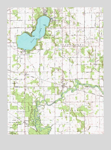
Bass Lake, IN USGS Topographic Map
Click on map above to begin viewing in our Map Viewer.

This topographic map contains these locations and features:
Feature Name Type Latitude Longitude GNIS ID View Map
Bartee DitchCanalN41.1937°W86.5931°430539View Map
Bass LakeLakeN41.2232°W86.5907°430561View Map
Bass LakePopulated PlaceN41.2073°W86.6020°430563View Map
Bass Lake - California Township Fire Department Station 1BuildingN41.1977°W86.6026°2626527View Map
Bass Lake - California Township Fire StationBuildingN41.1977°W86.6026°2701376View Map
Bass Lake Census Designated PlaceCensusN41.2304°W86.5845°2393329View Map
Bass Lake ChurchChurchN41.2445°W86.5672°430564View Map
Bass Lake State BeachBeachN41.2209°W86.5800°430565View Map
Bass Lake State Fish HatcheryLocaleN41.2389°W86.5670°452284View Map
Bass StationPopulated PlaceN41.1853°W86.6022°430566View Map
BeardstownPopulated PlaceN41.1381°W86.6025°430653View Map
Bennett Strip Airport (historical)AirportN41.1750°W86.5472°449295View Map
Brown ArmCanalN41.2373°W86.5478°431593View Map
Bube DitchCanalN41.1364°W86.5547°431706View Map
Casper ArmCanalN41.1998°W86.5136°432213View Map
Casper DitchCanalN41.1920°W86.5108°432214View Map
Castleman DitchCanalN41.2162°W86.5681°432232View Map
Cedar PointCliffN41.2220°W86.5931°432289View Map
Chapman ArmCanalN41.2334°W86.5439°432411View Map
Chapman BranchStreamN41.2162°W86.5039°432412View Map
Colman DitchCanalN41.2248°W86.6133°432806View Map
Cranberry PointCliffN41.2312°W86.5745°433085View Map
Fell DitchCanalN41.1831°W86.6233°434436View Map
Griner DitchCanalN41.1420°W86.5645°435511View Map
Gull PointCliffN41.2189°W86.5850°435555View Map
House DitchCanalN41.2178°W86.5217°436524View Map
James DitchCanalN41.2003°W86.5483°436924View Map
Keller DitchCanalN41.1531°W86.5253°437210View Map
Marks DitchCanalN41.2375°W86.6114°438633View Map
McGaffey DitchCanalN41.2495°W86.5158°438869View Map
Melody Drive-InLocaleN41.2000°W86.6039°2634481View Map
Milner ArmCanalN41.2273°W86.5272°439252View Map
North Bend CemeteryCemeteryN41.2120°W86.5367°440214View Map
OraPopulated PlaceN41.1739°W86.5531°440673View Map
Ora ArmCanalN41.1806°W86.5683°440674View Map
Ora CemeteryCemeteryN41.1803°W86.5531°440675View Map
Pigeon Roost HillSummitN41.1745°W86.6161°441125View Map
Scheuer DitchCanalN41.1514°W86.5378°443069View Map
Scoville ArmCanalN41.1998°W86.6083°443173View Map
Stadden DitchCanalN41.1284°W86.5211°444043View Map
Taylor DitchCanalN41.1664°W86.5947°444596View Map
Township of North BendCivilN41.2153°W86.5247°453679View Map
Township of TippecanoeCivilN41.1281°W86.5253°453897View Map
Van de Mark AirportAirportN41.2473°W86.5040°2676889View Map
Vergin ArmCanalN41.2392°W86.5395°445247View Map
Weyand DitchCanalN41.1550°W86.6114°445873View Map
Wheeler AirportAirportN41.1896°W86.6026°449228View Map
WinonaPopulated PlaceN41.2362°W86.5695°446187View Map
Wolfram ArmCanalN41.1875°W86.5092°446266View Map

Note: Coordinates in the location and feature list above are referenced to NAD83 datum.


Copyright (C) 2008-2025 Ryan Niemi / Sunset Dynamics ... All Rights Reserved