TopoQuest Logo
Do you find TopoQuest useful?
Help keep TopoQuest running and adding new maps/features by donating!
Bitcoin:  19c7KJd3qBynnjoSw5npx9KScwjBe4ifkT
Litecoin:  LXs6TkuXGGXo1vDsWCkWVdjQX94eUKd6ui
Home View Maps Find Maps Find Places Resources & Links


Bland, Virginia Topographic Map

USGS Map Title: Bland, VA
USGS Map MRC: 37081A1
DRG (GeoTIFF) Download: o37081a1.tif


Neighboring USGS Topographic Map Quads:


  Bastian, VA  
37081B2
 

  Rocky Gap, VA  
37081B1
 

  Mechanicsburg, VA  
37080B8
 

  Big Bend, VA  
37081A2
 

  Bland, VA  
37081A1
 

  Long Spur, VA  
37080A8
 

  Crockett, VA  
36081H2
 

  Wytheville, VA  
36081H1
 

  Max Meadows, VA  
36080H8


Map MRC Location:

N38°
W82°
N38°
W81°
H8 H7 H6 H5 H4 H3 H2 H1
G8 G7 G6 G5 G4 G3 G2 G1
F8 F7 F6 F5 F4 F3 F2 F1
E8 E7 E6 E5 E4 E3 E2 E1
D8 D7 D6 D5 D4 D3 D2 D1
C8 C7 C6 C5 C4 C3 C2 C1
B8 B7 B6 B5 B4 B3 B2 B1
A8 A7 A6 A5 A4 A3 A2 A1
N37°
W82°
N37°
W81°

Bland, VA USGS 1:24K Topographic Map Preview:
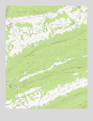
Bland, VA USGS Topographic Map
Click on map above to begin viewing in our Map Viewer.

This topographic map contains these locations and features:
Feature Name Type Latitude Longitude GNIS ID View Map
BlandPopulated PlaceN37.1021°W81.1162°1498536View Map
Bland Census Designated PlaceCensusN37.1001°W81.1160°2629018View Map
Bland County CourthouseBuildingN37.1001°W81.1151°1494614View Map
Bland County Sheriff's OfficeBuildingN37.1000°W81.1154°2767019View Map
Bland County Volunteer Fire DepartmentBuildingN37.0992°W81.1147°2075542View Map
Bland County Volunteer Rescue SquadBuildingN37.1021°W81.1193°2075541View Map
Bland Elementary SchoolSchoolN37.1036°W81.1142°2498439View Map
Bland High SchoolSchoolN37.1031°W81.1140°2075548View Map
Bland Post OfficePost OfficeN37.1003°W81.1161°2766339View Map
Bob King BranchStreamN37.0557°W81.0448°1494615View Map
CarnotPopulated PlaceN37.0418°W81.0962°1492716View Map
Central ChurchChurchN37.1187°W81.0079°1482430View Map
Church BranchStreamN37.0462°W81.0670°1494619View Map
Crab Orchard CreekStreamN37.0926°W81.1034°1482784View Map
Creed BranchStreamN37.0421°W81.0806°1494622View Map
Crockett CemeteryCemeteryN37.0157°W81.0548°1482841View Map
District 2CivilN37.1113°W81.0532°1952417View Map
Helveys Mill CreekStreamN37.1187°W81.0087°1484024View Map
Interchange 47CrossingN37.0312°W81.1193°1494633View Map
Little Creek School (historical)SchoolN37.0465°W81.0659°1494641View Map
Little Walker MountainSummitN37.0393°W81.0556°1493556View Map
Mount View ChurchChurchN37.0240°W81.0784°1485652View Map
Mountain View CemeteryCemeteryN37.0237°W81.0781°1501347View Map
Newberry Chapel (historical)ChurchN37.0787°W81.1243°1494648View Map
Newberrys Mill (historical)LocaleN37.0973°W81.0854°1494649View Map
Point PleasantPopulated PlaceN37.1243°W81.0168°1486310View Map
Polly BranchStreamN37.0501°W81.0562°1494650View Map
Poplar Spring BranchStreamN37.0385°W81.0895°1494651View Map
Saint Lukes CemeteryCemeteryN37.0073°W81.0990°1501361View Map
Saint Lukes ChurchChurchN37.0076°W81.0990°1486861View Map
Seddon District (historical)CivilN37.1035°W81.1140°1927492View Map
Strader ChurchChurchN37.0471°W81.0648°1487650View Map
Sunnyside School (historical)SchoolN37.0271°W81.0370°1501373View Map
Surrat BranchStreamN37.0446°W81.0743°1494666View Map
Temple Hill CemeteryCemeteryN37.1082°W81.1193°1487809View Map
The Brick ChurchChurchN37.0262°W81.0373°1487818View Map
The Brick Church CemeteryCemeteryN37.0268°W81.0376°1501374View Map
The FlatwoodsAreaN37.0668°W81.0345°1494628View Map
Town CreekStreamN37.1001°W81.1243°1487967View Map
Town RidgeRidgeN37.1035°W81.0995°1494667View Map
Turkey GapGapN37.0648°W81.0868°1488021View Map
Walker Creek Church (historical)ChurchN37.0951°W81.0726°1494668View Map
Walker Creek School (historical)SchoolN37.0940°W81.0743°1494669View Map
Waterfall BranchStreamN37.0571°W81.0340°1494671View Map

Note: Coordinates in the location and feature list above are referenced to NAD83 datum.


Copyright (C) 2008-2024 Ryan Niemi / Sunset Dynamics ... All Rights Reserved