TopoQuest Logo
Do you find TopoQuest useful?
Help keep TopoQuest running and adding new maps/features by donating!
Bitcoin:  19c7KJd3qBynnjoSw5npx9KScwjBe4ifkT
Litecoin:  LXs6TkuXGGXo1vDsWCkWVdjQX94eUKd6ui
Home View Maps Find Maps Find Places Resources & Links


Little Cypress, Kentucky Topographic Map

USGS Map Title: Little Cypress, KY
USGS Map MRC: 37088A4
DRG (GeoTIFF) Download: o37088a4.tif


Neighboring USGS Topographic Map Quads:


  Paducah NE, IL  
37088B5
 

  Smithland, KY  
37088B4
 

  Burna, KY  
37088B3
 

  Paducah East, KY  
37088A5
 

  Little Cypress, KY  
37088A4
 

  Calvert City, KY  
37088A3
 

  Symsonia, KY  
36088H5
 

  Elva, KY  
36088H4
 

  Briensburg, KY  
36088H3


Map MRC Location:

N38°
W89°
N38°
W88°
H8 H7 H6 H5 H4 H3 H2 H1
G8 G7 G6 G5 G4 G3 G2 G1
F8 F7 F6 F5 F4 F3 F2 F1
E8 E7 E6 E5 E4 E3 E2 E1
D8 D7 D6 D5 D4 D3 D2 D1
C8 C7 C6 C5 C4 C3 C2 C1
B8 B7 B6 B5 B4 B3 B2 B1
A8 A7 A6 A5 A4 A3 A2 A1
N37°
W89°
N37°
W88°

Little Cypress, KY USGS 1:24K Topographic Map Preview:
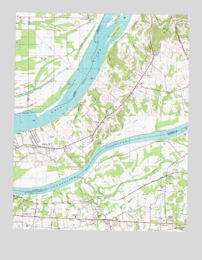
Little Cypress, KY USGS Topographic Map
Click on map above to begin viewing in our Map Viewer.

This topographic map contains these locations and features:
Feature Name Type Latitude Longitude GNIS ID View Map
AltonaPopulated PlaceN37.0523°W88.3961°507390View Map
Angle CreekStreamN37.0139°W88.4228°485958View Map
Angle CreekPopulated PlaceN37.0037°W88.3931°2743707View Map
Avery LakeLakeN37.0804°W88.4863°403759View Map
Barrett BranchStreamN37.0109°W88.4309°486435View Map
Beaverdam LakeLakeN37.0704°W88.4923°404069View Map
Beaverdam SloughGutN37.0434°W88.4884°486632View Map
Bellamy CemeteryCemeteryN37.0728°W88.4536°486800View Map
Burgess PondLakeN37.1096°W88.4502°405218View Map
Buzzard BranchStreamN37.0140°W88.4757°2743711View Map
Buzzard CreekStreamN37.0201°W88.4873°488532View Map
Caney CreekStreamN37.0806°W88.4478°488829View Map
Chestnut Hill ChurchChurchN37.0476°W88.4839°489449View Map
Clear LakeReservoirN37.0979°W88.4796°406226View Map
Cloud CrossingPopulated PlaceN37.0328°W88.3884°507718View Map
Cottonwood BarBarN37.0845°W88.4600°406628View Map
Crowell LandingPopulated PlaceN37.0553°W88.4953°507789View Map
Cypress CreekStreamN37.0303°W88.4520°490528View Map
Davis CreekStreamN37.1081°W88.4314°490660View Map
Drake BranchStreamN37.0592°W88.4814°491089View Map
Echo SpringSpringN37.1169°W88.3917°491547View Map
Echo Spring BranchStreamN37.1237°W88.3881°491548View Map
Fellowship ChurchChurchN37.0899°W88.4037°2632191View Map
Goodlow SloughStreamN37.0734°W88.4550°492981View Map
Hodges CreekStreamN37.0359°W88.4503°494337View Map
Howard CemeteryCemeteryN37.0042°W88.3934°494657View Map
Hurley CemeteryCemeteryN37.0653°W88.4339°494798View Map
Kincaid MoundsSummitN37.0817°W88.4928°411478View Map
LedbetterPopulated PlaceN37.0476°W88.4770°508437View Map
Ledbetter Census Designated PlaceCensusN37.0520°W88.4964°2403225View Map
Ledbetter Elementary SchoolSchoolN37.0627°W88.4362°2632195View Map
Ledbetter Fire DistrictBuildingN37.0479°W88.4725°2636564View Map
Ledbetter Fire District Station 2BuildingN37.0820°W88.3807°2637385View Map
Lee CreekStreamN37.0578°W88.3975°496165View Map
Leeper CemeteryCemeteryN37.0800°W88.3898°496176View Map
Leonard CemeteryCemeteryN37.0086°W88.4393°496289View Map
Little CypressPopulated PlaceN37.0167°W88.4462°508477View Map
Little Cypress CemeteryCemeteryN37.0181°W88.4466°2775757View Map
Little Cypress CreekStreamN37.0298°W88.4509°496700View Map
Little White Oak CreekStreamN37.0220°W88.4692°496895View Map
Mud CreekStreamN37.0487°W88.4356°498979View Map
New LibertyPopulated PlaceN37.1220°W88.4478°414440View Map
New Liberty CemeteryCemeteryN37.1209°W88.4470°1820656View Map
Oak Grove CemeteryCemeteryN37.0620°W88.4386°499658View Map
Ohio Valley Baptist ChurchChurchN37.0467°W88.4637°499780View Map
Possum TrotPopulated PlaceN37.0056°W88.4306°501168View Map
Possum Trot - Sharpe Fire Department Station 2BuildingN37.0071°W88.4338°2636784View Map
Robertson CemeteryCemeteryN37.0850°W88.4106°502072View Map
Sand Hill CemeteryCemeteryN37.0500°W88.4389°502909View Map
Saunders RidgeRidgeN37.0428°W88.4284°2743733View Map
Siloam ChurchChurchN37.1220°W88.4964°418499View Map
Thompson ChapelChurchN37.0901°W88.4036°505201View Map
Threlkeld CreekStreamN37.1031°W88.4348°505257View Map
Towhead IslandIslandN37.1151°W88.4275°505373View Map
Upper Hodge LandingPopulated PlaceN37.0348°W88.4531°509266View Map
Vaughn ChapelChurchN37.0076°W88.4264°505994View Map
White Oak CreekStreamN37.0228°W88.4709°506618View Map
Yancy CreekStreamN37.0203°W88.4959°507191View Map

Note: Coordinates in the location and feature list above are referenced to NAD83 datum.


Copyright (C) 2008-2025 Ryan Niemi / Sunset Dynamics ... All Rights Reserved