TopoQuest Logo
Do you find TopoQuest useful?
Help keep TopoQuest running and adding new maps/features by donating!
Bitcoin:  19c7KJd3qBynnjoSw5npx9KScwjBe4ifkT
Litecoin:  LXs6TkuXGGXo1vDsWCkWVdjQX94eUKd6ui
Home View Maps Find Maps Find Places Resources & Links


Burna, Kentucky Topographic Map

USGS Map Title: Burna, KY
USGS Map MRC: 37088B3
DRG (GeoTIFF) Download: o37088b3.tif


Neighboring USGS Topographic Map Quads:


  Golconda, IL  
37088C4
 

  Lola, KY  
37088C3
 

  Salem, KY  
37088C2
 

  Smithland, KY  
37088B4
 

  Burna, KY  
37088B3
 

  Dycusburg, KY  
37088B2
 

  Little Cypress, KY  
37088A4
 

  Calvert City, KY  
37088A3
 

  Grand Rivers, KY  
37088A2


Map MRC Location:

N38°
W89°
N38°
W88°
H8 H7 H6 H5 H4 H3 H2 H1
G8 G7 G6 G5 G4 G3 G2 G1
F8 F7 F6 F5 F4 F3 F2 F1
E8 E7 E6 E5 E4 E3 E2 E1
D8 D7 D6 D5 D4 D3 D2 D1
C8 C7 C6 C5 C4 C3 C2 C1
B8 B7 B6 B5 B4 B3 B2 B1
A8 A7 A6 A5 A4 A3 A2 A1
N37°
W89°
N37°
W88°

Burna, KY USGS 1:24K Topographic Map Preview:
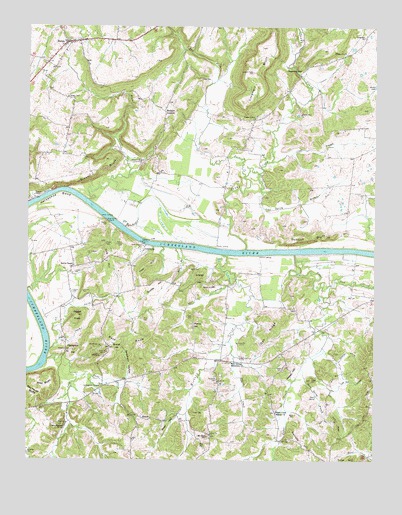
Burna, KY USGS Topographic Map
Click on map above to begin viewing in our Map Viewer.

This topographic map contains these locations and features:
Feature Name Type Latitude Longitude GNIS ID View Map
Anderson CemeteryCemeteryN37.1270°W88.3748°485934View Map
Atwood MinesMineN37.1751°W88.3075°486131View Map
Bald KnobSummitN37.1603°W88.3428°486268View Map
Barnes Farm AirportAirportN37.2316°W88.3177°517343View Map
Barricks HillSummitN37.1301°W88.2759°486442View Map
Beachdale SchoolSchoolN37.2376°W88.2767°486503View Map
Bissell BluffCliffN37.2081°W88.3475°487349View Map
Bissell CreekStreamN37.2001°W88.3528°487350View Map
BurnaPopulated PlaceN37.2456°W88.3606°488441View Map
Burna Census Designated PlaceCensusN37.2455°W88.3589°2629581View Map
Burna Community Fire DepartmentBuildingN37.2395°W88.3680°2636946View Map
Cedar Grove ChurchChurchN37.2239°W88.2923°489203View Map
Clear BranchStreamN37.2112°W88.2867°489602View Map
Cook Spring BranchStreamN37.2081°W88.2914°490010View Map
Deason Cochran CemeteryCemeteryN37.1873°W88.3403°490743View Map
Dobson BluffCliffN37.1889°W88.2734°490939View Map
Doom CemeteryCemeteryN37.1484°W88.2725°491008View Map
Doom SpringSpringN37.1430°W88.2709°491010View Map
Doom Spring BranchStreamN37.1517°W88.2764°491011View Map
Dry ForkStreamN37.2067°W88.2961°491187View Map
Dunlap CemeteryCemeteryN37.1939°W88.3748°491316View Map
Dunlap HillSummitN37.1753°W88.3289°491317View Map
Dunn CreekStreamN37.1492°W88.3567°491327View Map
Durham CemeteryCemeteryN37.1737°W88.3550°491344View Map
Ferguson CemeteryCemeteryN37.1350°W88.3636°492030View Map
Ferguson CreekStreamN37.1537°W88.3678°492034View Map
Franklin QuarryMineN37.2014°W88.3731°492456View Map
Frozen KnobSummitN37.1664°W88.3567°492585View Map
Grand Lakes Fire District 3BuildingN37.1591°W88.2777°2636278View Map
Grassham HollowValleyN37.1481°W88.3389°493137View Map
Gravel HillSummitN37.1578°W88.3445°493178View Map
Green-Johnson CemeteryCemeteryN37.1867°W88.3331°493305View Map
Hampton CemeteryCemeteryN37.1564°W88.3600°493654View Map
Hampton HillSummitN37.1567°W88.3586°493658View Map
Harp RidgeRidgeN37.1342°W88.2631°493778View Map
Harris HillSummitN37.1631°W88.3148°493809View Map
Haw HillSummitN37.1806°W88.3323°493876View Map
Hazel BranchStreamN37.1762°W88.2986°493944View Map
HeaterPopulated PlaceN37.1370°W88.3303°508213View Map
Heater CemeteryCemeteryN37.1389°W88.3153°493979View Map
Hickory CreekStreamN37.1845°W88.3039°494122View Map
Horseshoe BendBendN37.1995°W88.3639°494607View Map
Hudson MineMineN37.2248°W88.2764°494727View Map
Jewel HillSummitN37.1359°W88.3245°495258View Map
Kibbler HillSummitN37.1776°W88.3125°495715View Map
Klondike MineMineN37.2109°W88.3336°495827View Map
Kolb QuarryMineN37.1551°W88.3506°495871View Map
Lee-Goldwell CemeteryCemeteryN37.1848°W88.3534°496173View Map
Leeper CemeteryCemeteryN37.1512°W88.2825°496177View Map
Leeper HillSummitN37.1512°W88.2814°496178View Map
Lemen CemeteryCemeteryN37.1931°W88.3466°496282View Map
Lemen LandingPopulated PlaceN37.1948°W88.3478°508442View Map
Lick CreekStreamN37.1756°W88.2656°496479View Map
Livingston ChapelChurchN37.1459°W88.3484°496911View Map
Livingston CountyCivilN37.2097°W88.3538°516916View Map
Lockett CemeteryCemeteryN37.1792°W88.3578°496930View Map
Lockhart BluffCliffN37.2403°W88.2864°496932View Map
Lovelace ChurchChurchN37.2473°W88.2542°497217View Map
Lovelace MineMineN37.2428°W88.2611°497218View Map
Low Gap HollowValleyN37.1456°W88.2652°497242View Map
Lower Ferguson SpringSpringN37.1346°W88.3613°497278View Map
Martin CemeteryCemeteryN37.1378°W88.2781°497603View Map
Mint SpringsSpringN37.1543°W88.2983°498428View Map
Mint Springs Missionary ChurchChurchN37.1531°W88.3014°498429View Map
Mitchell LandingPopulated PlaceN37.1842°W88.2886°508619View Map
Mount Zion SchoolSchoolN37.1317°W88.3100°498957View Map
Moxley LandingPopulated PlaceN37.1862°W88.3059°508655View Map
Mullikin JunctionPopulated PlaceN37.2259°W88.3253°508659View Map
Oak RidgeRidgeN37.1609°W88.2881°499718View Map
Peck CemeteryCemeteryN37.2350°W88.3117°500339View Map
Phillips CemeteryCemeteryN37.2298°W88.3603°500532View Map
Polecat HollowValleyN37.1535°W88.2626°501003View Map
Robertson CemeteryCemeteryN37.1484°W88.3064°502074View Map
Rocked SpringSpringN37.1577°W88.3481°502161View Map
Rocky BranchStreamN37.1859°W88.3209°502227View Map
Ross CemeteryCemeteryN37.1292°W88.3125°502362View Map
Ross CemeteryCemeteryN37.1659°W88.3331°502363View Map
Rudd QuarryMineN37.1939°W88.3461°502454View Map
Sandy CreekStreamN37.1862°W88.2956°502979View Map
Scotts ChapelChurchN37.1809°W88.3584°503109View Map
Smith CreekStreamN37.1564°W88.3667°503779View Map
Snglin CreekStreamN37.1559°W88.3014°503852View Map
Steep HollowValleyN37.1596°W88.3634°504319View Map
Sugar CreekStreamN37.1845°W88.2784°504655View Map
Sugar Creek Mission ChurchChurchN37.1389°W88.2853°504661View Map
Taylor CemeteryCemeteryN37.1664°W88.3153°504999View Map
Tracey CemeteryCemeteryN37.1737°W88.3586°505455View Map
Vick HillSummitN37.1820°W88.3467°506036View Map
Vicks BluffsCliffN37.1473°W88.3689°506040View Map
VicksburgPopulated PlaceN37.1853°W88.3328°509286View Map
Wolfe CemeteryCemeteryN37.1798°W88.3159°507032View Map

Note: Coordinates in the location and feature list above are referenced to NAD83 datum.


Copyright (C) 2008-2024 Ryan Niemi / Sunset Dynamics ... All Rights Reserved