TopoQuest Logo
Do you find TopoQuest useful?
Help keep TopoQuest running and adding new maps/features by donating!
Bitcoin:  19c7KJd3qBynnjoSw5npx9KScwjBe4ifkT
Litecoin:  LXs6TkuXGGXo1vDsWCkWVdjQX94eUKd6ui
Home View Maps Find Maps Find Places Resources & Links


Little Honey Creek, Oregon Topographic Map

USGS Map Title: Little Honey Creek, OR
USGS Map MRC: 42120D2
DRG (GeoTIFF) Download: o42120d2.tif


Neighboring USGS Topographic Map Quads:


  Coglan Buttes SE, OR  
42120E3
 

  Lake Abert South, OR  
42120E2
 

  Cooper Draw, OR  
42120E1
 

  Valley Falls, OR  
42120D3
 

  Little Honey Creek, OR  
42120D2
 

  Drake Peak NE, OR  
42120D1
 

  Crooked Creek Valley, OR  
42120C3
 

  Crook Peak, OR  
42120C2
 

  Drake Peak, OR  
42120C1


Map MRC Location:

N43°
W121°
N43°
W120°
H8 H7 H6 H5 H4 H3 H2 H1
G8 G7 G6 G5 G4 G3 G2 G1
F8 F7 F6 F5 F4 F3 F2 F1
E8 E7 E6 E5 E4 E3 E2 E1
D8 D7 D6 D5 D4 D3 D2 D1
C8 C7 C6 C5 C4 C3 C2 C1
B8 B7 B6 B5 B4 B3 B2 B1
A8 A7 A6 A5 A4 A3 A2 A1
N42°
W121°
N42°
W120°

Little Honey Creek, OR USGS 1:24K Topographic Map Preview:
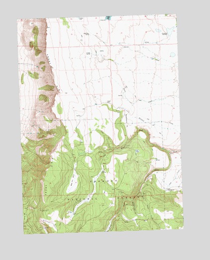
Little Honey Creek, OR USGS Topographic Map
Click on map above to begin viewing in our Map Viewer.

This topographic map contains these locations and features:
Feature Name Type Latitude Longitude GNIS ID View Map
Abert Rim ViewpointParkN42.4304°W120.2177°1131105View Map
Abert SpringSpringN42.3846°W120.2206°1131103View Map
Blue SpringSpringN42.4093°W120.1884°1117866View Map
Camp Warner (historical)MilitaryN42.3983°W120.1364°1120893View Map
Can SpringSpringN42.3807°W120.1690°1118552View Map
Can Spring Recreation SiteLocaleN42.3807°W120.1688°1952919View Map
Chandler CabinLocaleN42.4496°W120.1822°1118814View Map
First Swale CreekStreamN42.3979°W120.1597°1120751View Map
Fish Creek Waterhole Number Forty-fourReservoirN42.4941°W120.1484°1158715View Map
Fitzgerald DamDamN42.4921°W120.1282°1133538View Map
Fitzgerald ReservoirReservoirN42.4900°W120.1315°1120794View Map
Little Honey CreekStreamN42.4199°W120.1355°1123206View Map
O'Hallihan SpringSpringN42.4895°W120.1947°1124883View Map
Pine SpringSpringN42.4721°W120.2308°1163970View Map
Priday LakeLakeN42.5000°W120.2028°1125664View Map
Priday SpringSpringN42.4787°W120.1944°1125666View Map
Second Swale CreekStreamN42.3932°W120.1663°1126721View Map
Swale TrailheadLocaleN42.3780°W120.1463°2548778View Map
Vee LakeLakeN42.4213°W120.1591°1128518View Map
Vee Lake Boat AccessLocaleN42.4218°W120.1617°2700206View Map
Vee Lake TrailheadLocaleN42.4222°W120.1595°2548780View Map
Vee SpringsSpringN42.4164°W120.1466°1128519View Map
Washing Machine FlatFlatN42.4388°W120.1683°1128693View Map
White Pine MarshSwampN42.4070°W120.2097°1128986View Map

Note: Coordinates in the location and feature list above are referenced to NAD83 datum.


Copyright (C) 2008-2025 Ryan Niemi / Sunset Dynamics ... All Rights Reserved