TopoQuest Logo
Do you find TopoQuest useful?
Help keep TopoQuest running and adding new maps/features by donating!
Bitcoin:  19c7KJd3qBynnjoSw5npx9KScwjBe4ifkT
Litecoin:  LXs6TkuXGGXo1vDsWCkWVdjQX94eUKd6ui
Home View Maps Find Maps Find Places Resources & Links


Valley Falls, Oregon Topographic Map

USGS Map Title: Valley Falls, OR
USGS Map MRC: 42120D3
DRG (GeoTIFF) Download: o42120d3.tif


Neighboring USGS Topographic Map Quads:


  Tucker Hill, OR  
42120E4
 

  Coglan Buttes SE, OR  
42120E3
 

  Lake Abert South, OR  
42120E2
 

  Clover Flat, OR  
42120D4
 

  Valley Falls, OR  
42120D3
 

  Little Honey Creek, OR  
42120D2
 

  Big Baldy, OR  
42120C4
 

  Crooked Creek Valley, OR  
42120C3
 

  Crook Peak, OR  
42120C2


Map MRC Location:

N43°
W121°
N43°
W120°
H8 H7 H6 H5 H4 H3 H2 H1
G8 G7 G6 G5 G4 G3 G2 G1
F8 F7 F6 F5 F4 F3 F2 F1
E8 E7 E6 E5 E4 E3 E2 E1
D8 D7 D6 D5 D4 D3 D2 D1
C8 C7 C6 C5 C4 C3 C2 C1
B8 B7 B6 B5 B4 B3 B2 B1
A8 A7 A6 A5 A4 A3 A2 A1
N42°
W121°
N42°
W120°

Valley Falls, OR USGS 1:24K Topographic Map Preview:
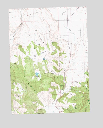
Valley Falls, OR USGS Topographic Map
Click on map above to begin viewing in our Map Viewer.

This topographic map contains these locations and features:
Feature Name Type Latitude Longitude GNIS ID View Map
Bobs LakeLakeN42.4393°W120.3220°1117893View Map
Boggy LakeSwampN42.3936°W120.2631°1117901View Map
Bowersox LakeLakeN42.4462°W120.3263°1117994View Map
Bull MeadowFlatN42.4179°W120.3399°1118286View Map
Campbell MillLocaleN42.4054°W120.3583°1167391View Map
Chandler State ParkParkN42.4071°W120.2897°1118818View Map
Clover CreekStreamN42.4071°W120.2888°1119030View Map
Coyote CreekStreamN42.4813°W120.3558°1119455View Map
Coyote FlatFlatN42.4432°W120.3361°1119464View Map
Coyote Flat ReservoirReservoirN42.4652°W120.3516°1131008View Map
Crooked Creek ValleyValleyN42.3854°W120.3072°1119569View Map
Dicks CreekStreamN42.3838°W120.3097°1119937View Map
Dicks RanchLocaleN42.3796°W120.3225°1167389View Map
Dicks SpringSpringN42.4075°W120.3433°1119938View Map
Grouse FlatFlatN42.3857°W120.2508°1121462View Map
High Line DitchCanalN42.4277°W120.2552°1131007View Map
Hill SpringSpringN42.3769°W120.3546°1121835View Map
Indian SpringSpringN42.4736°W120.3314°1122244View Map
Indian Spring RidgeRidgeN42.4618°W120.3250°1122249View Map
Loveless CreekStreamN42.3765°W120.3091°1123540View Map
Loveless HomesteadLocaleN42.3799°W120.2758°1123541View Map
Mill LakeLakeN42.4200°W120.3328°1167390View Map
Moss CreekStreamN42.3985°W120.2919°1124392View Map
Moss MeadowFlatN42.3963°W120.2794°1124396View Map
O'Leary RanchLocaleN42.4402°W120.3408°1167393View Map
Passage RanchLocaleN42.4365°W120.2805°1167387View Map
Pete LakeReservoirN42.4483°W120.3060°1125315View Map
Pine CreekStreamN42.4640°W120.3691°1125391View Map
Reynolds ReservoirReservoirN42.3802°W120.3000°1131006View Map
Schmidt RanchLocaleN42.4352°W120.3705°1167392View Map
Simms RanchLocaleN42.4452°W120.2527°1126985View Map
Soda SpringsSpringN42.4097°W120.2714°1127192View Map
Valley FallsPopulated PlaceN42.4840°W120.2819°1128496View Map
Valley Falls Post Office (historical)Post OfficeN42.4840°W120.2819°1166091View Map
Wilson LakeLakeN42.4002°W120.2713°1129201View Map
Wilson SpringSpringN42.4035°W120.2799°1129207View Map
Woodchopper SpringSpringN42.4220°W120.3065°1129302View Map
Wright RanchLocaleN42.3796°W120.3000°1639099View Map

Note: Coordinates in the location and feature list above are referenced to NAD83 datum.


Copyright (C) 2008-2025 Ryan Niemi / Sunset Dynamics ... All Rights Reserved