TopoQuest Logo
Do you find TopoQuest useful?
Help keep TopoQuest running and adding new maps/features by donating!
Bitcoin:  19c7KJd3qBynnjoSw5npx9KScwjBe4ifkT
Litecoin:  LXs6TkuXGGXo1vDsWCkWVdjQX94eUKd6ui
Home View Maps Find Maps Find Places Resources & Links


Little York, Indiana Topographic Map

USGS Map Title: Little York, IN
USGS Map MRC: 38085F8
DRG (GeoTIFF) Download: o38085f8.tif


Neighboring USGS Topographic Map Quads:


  Vallonia, IN  
38086G1
 

  Tampico, IN  
38085G8
 

  Crothersville, IN  
38085G7
 

  Kossuth, IN  
38086F1
 

  Little York, IN  
38085F8
 

  Scottsburg, IN  
38085F7
 

  Salem, IN  
38086E1
 

  South Boston, IN  
38085E8
 

  Henryville, IN  
38085E7


Map MRC Location:

N39°
W86°
N39°
W85°
H8 H7 H6 H5 H4 H3 H2 H1
G8 G7 G6 G5 G4 G3 G2 G1
F8 F7 F6 F5 F4 F3 F2 F1
E8 E7 E6 E5 E4 E3 E2 E1
D8 D7 D6 D5 D4 D3 D2 D1
C8 C7 C6 C5 C4 C3 C2 C1
B8 B7 B6 B5 B4 B3 B2 B1
A8 A7 A6 A5 A4 A3 A2 A1
N38°
W86°
N38°
W85°

Little York, IN USGS 1:24K Topographic Map Preview:
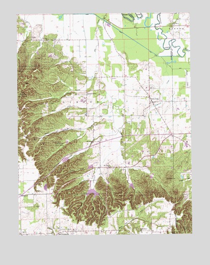
Little York, IN USGS Topographic Map
Click on map above to begin viewing in our Map Viewer.

This topographic map contains these locations and features:
Feature Name Type Latitude Longitude GNIS ID View Map
Bane HollowValleyN38.6861°W85.9524°430472View Map
Cammie Thomas DitchCanalN38.7181°W85.8825°432005View Map
Dowling HollowValleyN38.6561°W85.9536°433668View Map
Elk CreekStreamN38.7476°W85.9397°434075View Map
Elk Creek Fish and Game AreaParkN38.6501°W85.9472°446877View Map
Elk Creek Public Fishing AreaParkN38.6459°W85.9500°447667View Map
Elk Creek Structure Number 3DamN38.6631°W85.9466°447251View Map
Elk Creek Structure Number 7DamN38.6551°W85.9200°447072View Map
Elk Creek Structure Number 8DamN38.6584°W85.9050°447282View Map
Frank Garrett HollowValleyN38.6494°W85.9488°434756View Map
GeorgetownPopulated PlaceN38.6484°W85.9983°435026View Map
Gibson Township Little York Volunteer Fire DepartmentBuildingN38.7038°W85.9059°2626273View Map
GooseportPopulated PlaceN38.7101°W85.9408°452182View Map
Herron HollowValleyN38.6995°W85.9593°436063View Map
Little YorkPopulated PlaceN38.7028°W85.9050°449687View Map
Little York AirportAirportN38.6962°W85.9196°2717329View Map
McKnight HollowValleyN38.6483°W85.9440°438912View Map
Monroe HollowValleyN38.6588°W85.9406°439345View Map
New PhiladelphiaPopulated PlaceN38.6264°W85.9700°440097View Map
Nowing HollowValleyN38.6479°W85.9512°440363View Map
Pumpkin CenterPopulated PlaceN38.7042°W85.9505°441643View Map
Ridlen CemeteryCemeteryN38.6797°W85.9879°442005View Map
Rutherford HollowValleyN38.6833°W85.9388°442426View Map
Shantaky HollowValleyN38.6626°W85.9496°443287View Map
Smith HollowValleyN38.6479°W85.9447°443696View Map
Town of Little YorkCivilN38.6993°W85.9046°2396719View Map
Township of GibsonCivilN38.7024°W85.9541°453329View Map
Vic Swaim HillSummitN38.6567°W85.8902°449537View Map
Weddell CreekStreamN38.7184°W85.9328°445628View Map

Note: Coordinates in the location and feature list above are referenced to NAD83 datum.


Copyright (C) 2008-2024 Ryan Niemi / Sunset Dynamics ... All Rights Reserved