TopoQuest Logo
Do you find TopoQuest useful?
Help keep TopoQuest running and adding new maps/features by donating!
Bitcoin:  19c7KJd3qBynnjoSw5npx9KScwjBe4ifkT
Litecoin:  LXs6TkuXGGXo1vDsWCkWVdjQX94eUKd6ui
Home View Maps Find Maps Find Places Resources & Links


Crothersville, Indiana Topographic Map

USGS Map Title: Crothersville, IN
USGS Map MRC: 38085G7
DRG (GeoTIFF) Download: o38085g7.tif


Neighboring USGS Topographic Map Quads:


  Seymour, IN  
38085H8
 

  Chestnut Ridge, IN  
38085H7
 

  Hayden, IN  
38085H6
 

  Tampico, IN  
38085G8
 

  Crothersville, IN  
38085G7
 

  Deputy, IN  
38085G6
 

  Little York, IN  
38085F8
 

  Scottsburg, IN  
38085F7
 

  Blocher, IN  
38085F6


Map MRC Location:

N39°
W86°
N39°
W85°
H8 H7 H6 H5 H4 H3 H2 H1
G8 G7 G6 G5 G4 G3 G2 G1
F8 F7 F6 F5 F4 F3 F2 F1
E8 E7 E6 E5 E4 E3 E2 E1
D8 D7 D6 D5 D4 D3 D2 D1
C8 C7 C6 C5 C4 C3 C2 C1
B8 B7 B6 B5 B4 B3 B2 B1
A8 A7 A6 A5 A4 A3 A2 A1
N38°
W86°
N38°
W85°

Crothersville, IN USGS 1:24K Topographic Map Preview:
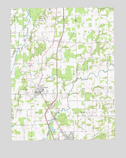
Crothersville, IN USGS Topographic Map
Click on map above to begin viewing in our Map Viewer.

This topographic map contains these locations and features:
Feature Name Type Latitude Longitude GNIS ID View Map
AustinPopulated PlaceN38.7584°W85.8080°430350View Map
Bedel CemeteryCemeteryN38.8653°W85.8375°430696View Map
Bedel DitchCanalN38.8556°W85.8372°430697View Map
Bethany ChurchChurchN38.7717°W85.8608°430865View Map
Blau DitchCanalN38.8095°W85.8427°431180View Map
Campbell CemeteryCemeteryN38.7830°W85.7565°432076View Map
Cana ChurchChurchN38.8442°W85.7739°432091View Map
Cana CreekStreamN38.8134°W85.7952°432092View Map
Cana Post Office (historical)Post OfficeN38.8409°W85.7594°453022View Map
Coryell CemeteryCemeteryN38.8422°W85.7919°433006View Map
CrothersvillePopulated PlaceN38.8006°W85.8416°433195View Map
Crothersville - Vernon Township Volunteer Fire DepartmentBuildingN38.7940°W85.8381°2626043View Map
Crothersville CemeteryCemeteryN38.7943°W85.8528°433196View Map
Crothersville Police DepartmentBuildingN38.7941°W85.8355°2758220View Map
Dens Ford DitchCanalN38.7712°W85.8502°433481View Map
East ArmCanalN38.8301°W85.8533°433864View Map
Gorrell CemeteryCemeteryN38.8030°W85.8142°435222View Map
Grassy CemeteryCemeteryN38.8225°W85.8318°435342View Map
Hall Sherman DitchCanalN38.7914°W85.8189°435618View Map
Harrod CemeteryCemeteryN38.7794°W85.7824°435808View Map
LangoonsPopulated PlaceN38.8370°W85.8572°452193View Map
Marion ChurchChurchN38.8626°W85.7616°438614View Map
McDonald DitchCanalN38.8656°W85.8464°438853View Map
Nehrt DitchCanalN38.7964°W85.8527°439986View Map
New Harmony ChurchChurchN38.7798°W85.7905°440054View Map
Quick CreekStreamN38.8039°W85.7858°441695View Map
RetreatPopulated PlaceN38.8245°W85.8533°441917View Map
Retreat DitchCanalN38.8262°W85.8666°441918View Map
Rider DitchCanalN38.8189°W85.8744°441988View Map
Town of CrothersvilleCivilN38.7946°W85.8398°2396669View Map
Township of JenningsCivilN38.7578°W85.7810°453509View Map
Township of VernonCivilN38.8140°W85.8418°453956View Map
UniontownPopulated PlaceN38.8459°W85.8258°445138View Map
Wesley ChapelChurchN38.7892°W85.7641°445692View Map
White Oak BranchStreamN38.7917°W85.8055°445949View Map

Note: Coordinates in the location and feature list above are referenced to NAD83 datum.


Copyright (C) 2008-2025 Ryan Niemi / Sunset Dynamics ... All Rights Reserved