TopoQuest Logo
Do you find TopoQuest useful?
Help keep TopoQuest running and adding new maps/features by donating!
Bitcoin:  19c7KJd3qBynnjoSw5npx9KScwjBe4ifkT
Litecoin:  LXs6TkuXGGXo1vDsWCkWVdjQX94eUKd6ui
Home View Maps Find Maps Find Places Resources & Links


Bates City, Missouri Topographic Map

USGS Map Title: Bates City, MO
USGS Map MRC: 39094A1
DRG (GeoTIFF) Download: o39094a1.tif


Neighboring USGS Topographic Map Quads:


  Buckner, MO  
39094B2
 

  Camden, MO  
39094B1
 

  Lexington West, MO  
39093B8
 

  Oak Grove, MO  
39094A2
 

  Bates City, MO  
39094A1
 

  Odessa North, MO  
39093A8
 

  Tarsney Lakes, MO  
38094H2
 

  Chapel Hill, MO  
38094H1
 

  Odessa South, MO  
38093H8


Map MRC Location:

N40°
W95°
N40°
W94°
H8 H7 H6 H5 H4 H3 H2 H1
G8 G7 G6 G5 G4 G3 G2 G1
F8 F7 F6 F5 F4 F3 F2 F1
E8 E7 E6 E5 E4 E3 E2 E1
D8 D7 D6 D5 D4 D3 D2 D1
C8 C7 C6 C5 C4 C3 C2 C1
B8 B7 B6 B5 B4 B3 B2 B1
A8 A7 A6 A5 A4 A3 A2 A1
N39°
W95°
N39°
W94°

Bates City, MO USGS 1:24K Topographic Map Preview:
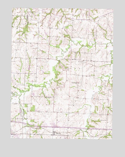
Bates City, MO USGS Topographic Map
Click on map above to begin viewing in our Map Viewer.

This topographic map contains these locations and features:
Feature Name Type Latitude Longitude GNIS ID View Map
Anderson CemeteryCemeteryN39.1209°W94.1012°713283View Map
Arnold CemeteryCemeteryN39.1178°W94.0434°2702399View Map
Bates CityPopulated PlaceN39.0061°W94.0724°713727View Map
Bates City CemeteryCemeteryN39.0064°W94.0556°713728View Map
Bates City Police DepartmentBuildingN39.0075°W94.0725°2752400View Map
Bates City Post OfficePost OfficeN39.0034°W94.0688°2783202View Map
Beckemeyer LakeReservoirN39.1164°W94.0775°761889View Map
Beckemeyer Lake DamDamN39.1183°W94.0769°761888View Map
Campbell CemeteryCemeteryN39.0474°W94.0038°715303View Map
City of Bates CityCivilN39.0047°W94.0661°2394079View Map
Dam C-23 DamDamN39.1233°W94.0236°760657View Map
Fairview School (historical)SchoolN39.0745°W94.0374°717811View Map
Ford Lake DamDamN39.0283°W94.0636°761886View Map
Foster College School (historical)SchoolN39.0539°W94.0433°718118View Map
Happy Hollow School (historical)SchoolN39.0397°W94.0830°719072View Map
Harris School (historical)SchoolN39.1146°W94.0307°747137View Map
Harry S Truman Regional AirportAirportN39.0176°W94.0881°758580View Map
Holiday LakeReservoirN39.0424°W94.0976°762694View Map
Horseshoe CreekStreamN39.0414°W94.1138°719862View Map
Ish School (historical)SchoolN39.1064°W94.0783°720177View Map
Kolkmeyer Lake DamDamN39.1050°W94.0252°762688View Map
Lafayette County Lake C-23ReservoirN39.1241°W94.0242°760658View Map
Lafayette County Lake J-21ReservoirN39.0687°W94.1029°760662View Map
Lafayette County Lake K-21ReservoirN39.0639°W94.0861°760642View Map
Little Horseshoe CreekStreamN39.0322°W94.1136°721250View Map
Meter Investments Lake DamDamN39.0017°W94.0569°761885View Map
O'Korn Lake DamDamN39.1033°W94.0602°762691View Map
Oak Grove Elementary SchoolSchoolN39.0037°W94.1237°2545329View Map
Oak Grove High SchoolSchoolN39.0024°W94.1208°2545450View Map
Owl CreekStreamN39.0439°W94.0166°723925View Map
Pleasant Grove School (historical)SchoolN39.0183°W94.0074°724505View Map
Pleasant Prairie CemeteryCemeteryN39.0867°W94.0924°724575View Map
Pleasant Prairie Church (historical)ChurchN39.0858°W94.0924°747138View Map
Pleasant Prairie School (historical)SchoolN39.0764°W94.0897°747136View Map
Potter Lake DamDamN39.1033°W94.0019°762689View Map
Seminary CreekStreamN39.0447°W94.1136°726198View Map
Sni Valley Fire Protection District Station 2BuildingN39.0067°W94.0713°2620484View Map
Township of ClayCivilN39.0836°W94.0198°766870View Map
Tucker BranchStreamN39.0414°W94.1224°727824View Map
Twentes LakeReservoirN39.1150°W94.0855°760656View Map
Varner DamDamN39.0433°W94.0986°762693View Map
Wellington-Napoleon Watershed Structure A-21a DamDamN39.1233°W94.0102°762800View Map
Wellington-Napoleon Watershed Structure C-21 DamDamN39.1217°W94.0302°760659View Map
Wellington-Napoleon Watershed Structure F-21 DamDamN39.1167°W94.0836°760655View Map
Wellington-Napoleon Watershed Structure H-21 DamDamN39.1200°W94.0986°761887View Map
Wellington-Napoleon Watershed Structure J-21 DamDamN39.0650°W94.1036°760661View Map
Wellington-Napoleon Watershed Structure K-21 DamDamN39.0633°W94.0852°760641View Map
Wellington-Napoleon Watershed Structure N-21 DamDamN39.0950°W94.0852°762690View Map
Wellington-Napoleon Watershed Structure N-22 DamDamN39.0983°W94.0819°762692View Map

Note: Coordinates in the location and feature list above are referenced to NAD83 datum.


Copyright (C) 2008-2025 Ryan Niemi / Sunset Dynamics ... All Rights Reserved