TopoQuest Logo
Do you find TopoQuest useful?
Help keep TopoQuest running and adding new maps/features by donating!
Bitcoin:  19c7KJd3qBynnjoSw5npx9KScwjBe4ifkT
Litecoin:  LXs6TkuXGGXo1vDsWCkWVdjQX94eUKd6ui
Home View Maps Find Maps Find Places Resources & Links


Buckner, Missouri Topographic Map

USGS Map Title: Buckner, MO
USGS Map MRC: 39094B2
DRG (GeoTIFF) Download: o39094b2.tif


Neighboring USGS Topographic Map Quads:


  Kearney, MO  
39094C3
 

  Excelsior Springs, MO  
39094C2
 

  Rayville, MO  
39094C1
 

  Missouri City, MO  
39094B3
 

  Buckner, MO  
39094B2
 

  Camden, MO  
39094B1
 

  Blue Springs, MO  
39094A3
 

  Oak Grove, MO  
39094A2
 

  Bates City, MO  
39094A1


Map MRC Location:

N40°
W95°
N40°
W94°
H8 H7 H6 H5 H4 H3 H2 H1
G8 G7 G6 G5 G4 G3 G2 G1
F8 F7 F6 F5 F4 F3 F2 F1
E8 E7 E6 E5 E4 E3 E2 E1
D8 D7 D6 D5 D4 D3 D2 D1
C8 C7 C6 C5 C4 C3 C2 C1
B8 B7 B6 B5 B4 B3 B2 B1
A8 A7 A6 A5 A4 A3 A2 A1
N39°
W95°
N39°
W94°

Buckner, MO USGS 1:24K Topographic Map Preview:
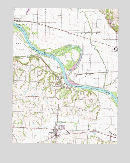
Buckner, MO USGS Topographic Map
Click on map above to begin viewing in our Map Viewer.

This topographic map contains these locations and features:
Feature Name Type Latitude Longitude GNIS ID View Map
Beasley CreekStreamN39.1897°W94.1908°2109408View Map
Blue MillLocaleN39.2061°W94.2233°734889View Map
BucknerPopulated PlaceN39.1325°W94.1986°735540View Map
Buckner Elementary SchoolSchoolN39.1371°W94.1963°2477803View Map
Buckner Hill CemeteryCemeteryN39.1253°W94.1997°714987View Map
Buckner Police DepartmentBuildingN39.1334°W94.1984°2752293View Map
Buckner Post OfficePost OfficeN39.1328°W94.1996°2477756View Map
City of BucknerCivilN39.1336°W94.1929°2393451View Map
City of LevasyCivilN39.1392°W94.1396°2395689View Map
City of OrrickCivilN39.2133°W94.1254°2396085View Map
ClevengerPopulated PlaceN39.2367°W94.2216°739632View Map
Clevenger SchoolSchoolN39.2433°W94.2213°715971View Map
Cogswell School (historical)SchoolN39.1575°W94.1402°734888View Map
Combs School (historical)SchoolN39.1389°W94.2491°734886View Map
Cooley LakeReservoirN39.2477°W94.2328°716232View Map
Cooley Lake BendBendN39.2228°W94.2342°2109185View Map
Cooleys (historical)Populated PlaceN39.2456°W94.2288°740167View Map
Dillen CemeteryCemeteryN39.2433°W94.1977°716899View Map
Egypt BottomBendN39.1978°W94.1608°730091View Map
Egypt School (historical)SchoolN39.1895°W94.1602°747115View Map
Excelsior Springs JunctionPopulated PlaceN39.2378°W94.2405°740841View Map
Fire PrairieAreaN39.1442°W94.1733°734890View Map
Fire Prairie LakeLakeN39.1420°W94.1749°734891View Map
Fishing RiverStreamN39.1753°W94.1408°717956View Map
Fishing River BendBendN39.1717°W94.1328°2109407View Map
Fort Osage (historical)MilitaryN39.1875°W94.1931°754185View Map
Fort Osage Fire Protection District HeadquartersBuildingN39.1379°W94.1912°2621253View Map
Fort Osage Historic SiteParkN39.1881°W94.1919°1940212View Map
Hayes ParkParkN39.1822°W94.1963°719259View Map
Jackass BendBendN39.2014°W94.1969°2109187View Map
Lawnwood School (historical)SchoolN39.1975°W94.2436°734884View Map
LevasyPopulated PlaceN39.1356°W94.1330°720926View Map
Levasy Post OfficePost OfficeN39.1348°W94.1333°2782914View Map
Little Blue BendBendN39.2081°W94.2175°2109186View Map
Little Blue RiverStreamN39.2078°W94.2186°721159View Map
Orrick Elementary SchoolSchoolN39.2132°W94.1299°2545078View Map
Orrick Fire Protection DistrictBuildingN39.2193°W94.1280°2621571View Map
Orrick High SchoolSchoolN39.2138°W94.1300°2545273View Map
Prairie Dell School (historical)SchoolN39.1578°W94.2147°734885View Map
Reber School (historical)SchoolN39.1586°W94.1769°734887View Map
SibleyPopulated PlaceN39.1786°W94.1933°735854View Map
Sibley BendBendN39.1786°W94.1681°2109406View Map
Sibley Orchards Lake DamDamN39.1700°W94.1902°762607View Map
Sibley Post OfficePost OfficeN39.1774°W94.1997°2477779View Map
Six-MileCivilN39.1642°W94.2361°734467View Map
Springer Lake DamDamN39.1633°W94.2086°761709View Map
Township of Fort OsageCivilN39.1440°W94.2113°766801View Map
Township of OrrickCivilN39.2191°W94.1371°767273View Map
Union ChurchChurchN39.2008°W94.1577°727998View Map
Village of SibleyCivilN39.1759°W94.2009°2399818View Map

Note: Coordinates in the location and feature list above are referenced to NAD83 datum.


Copyright (C) 2008-2025 Ryan Niemi / Sunset Dynamics ... All Rights Reserved