TopoQuest Logo
Do you find TopoQuest useful?
Help keep TopoQuest running and adding new maps/features by donating!
Bitcoin:  19c7KJd3qBynnjoSw5npx9KScwjBe4ifkT
Litecoin:  LXs6TkuXGGXo1vDsWCkWVdjQX94eUKd6ui
Home View Maps Find Maps Find Places Resources & Links


Camden, Missouri Topographic Map

USGS Map Title: Camden, MO
USGS Map MRC: 39094B1
DRG (GeoTIFF) Download: o39094b1.tif


Neighboring USGS Topographic Map Quads:


  Excelsior Springs, MO  
39094C2
 

  Rayville, MO  
39094C1
 

  Richmond, MO  
39093C8
 

  Buckner, MO  
39094B2
 

  Camden, MO  
39094B1
 

  Lexington West, MO  
39093B8
 

  Oak Grove, MO  
39094A2
 

  Bates City, MO  
39094A1
 

  Odessa North, MO  
39093A8


Map MRC Location:

N40°
W95°
N40°
W94°
H8 H7 H6 H5 H4 H3 H2 H1
G8 G7 G6 G5 G4 G3 G2 G1
F8 F7 F6 F5 F4 F3 F2 F1
E8 E7 E6 E5 E4 E3 E2 E1
D8 D7 D6 D5 D4 D3 D2 D1
C8 C7 C6 C5 C4 C3 C2 C1
B8 B7 B6 B5 B4 B3 B2 B1
A8 A7 A6 A5 A4 A3 A2 A1
N39°
W95°
N39°
W94°

Camden, MO USGS 1:24K Topographic Map Preview:
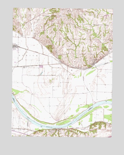
Camden, MO USGS Topographic Map
Click on map above to begin viewing in our Map Viewer.

This topographic map contains these locations and features:
Feature Name Type Latitude Longitude GNIS ID View Map
AlbanyPopulated PlaceN39.2233°W94.1133°730045View Map
Barsher CemeteryCemeteryN39.2261°W94.0852°713701View Map
Bates City Quad Number 2 DamDamN39.1267°W94.0302°761890View Map
Big Lake (historical)LakeN39.1770°W94.0902°737853View Map
Brady CreekStreamN39.1545°W94.0274°714620View Map
CamdenPopulated PlaceN39.1972°W94.0230°715228View Map
Camden BendBendN39.1592°W94.0114°2109446View Map
Camden JunctionPopulated PlaceN39.1917°W94.0388°740720View Map
City of CamdenCivilN39.2001°W94.0196°2393509View Map
City of FlemingCivilN39.1955°W94.0521°2394769View Map
City of NapoleonCivilN39.1294°W94.0857°2395149View Map
Cravens CemeteryCemeteryN39.2119°W94.0016°716469View Map
East Fork Rollins CreekStreamN39.2289°W94.1011°717300View Map
Egypt Bottom School (historical)SchoolN39.1761°W94.0133°747124View Map
Exchange MineMineN39.1392°W94.0094°747125View Map
Fire Prairie CreekStreamN39.1378°W94.0991°717930View Map
Fitch SchoolSchoolN39.2339°W94.0097°717963View Map
FlemingPopulated PlaceN39.1992°W94.0655°718010View Map
FloydPopulated PlaceN39.1925°W94.1108°730099View Map
Friendship ChurchChurchN39.2342°W94.0236°718243View Map
Hannah School (historical)SchoolN39.2422°W94.1041°747116View Map
Hicklin BranchStreamN39.1331°W94.0694°719419View Map
Lafayette A-21 LakeReservoirN39.1256°W94.0021°760424View Map
Lafayette County Lake C-21ReservoirN39.1251°W94.0298°760660View Map
Lewis CemeteryCemeteryN39.2386°W94.0938°720939View Map
Lillard SchoolSchoolN39.2425°W94.0808°721054View Map
Lorelei Subdivision Lake DamDamN39.1300°W94.0552°762685View Map
Missouri Valley School (historical)SchoolN39.1628°W94.0638°747117View Map
Napolean BendBendN39.1389°W94.0986°2109429View Map
NapoleonPopulated PlaceN39.1314°W94.0708°723115View Map
Napoleon Post OfficePost OfficeN39.1305°W94.0744°2782716View Map
New Hope ChurchChurchN39.2497°W94.0433°730166View Map
OrrickPopulated PlaceN39.2128°W94.1227°723850View Map
Orrick Police DepartmentBuildingN39.2130°W94.1246°2752143View Map
Orrick Post OfficePost OfficeN39.2128°W94.1234°2782682View Map
Panther CreekStreamN39.1920°W94.0613°723984View Map
Ralph LakeLakeN39.1866°W94.0885°725081View Map
Ray County Dam Number A-27DamN39.2450°W94.0069°760575View Map
Ray County Number A-27 LakeReservoirN39.2438°W94.0092°760576View Map
Rollins CreekStreamN39.1842°W94.0388°730200View Map
Saint Paul CemeteryCemeteryN39.1308°W94.0762°2702404View Map
Show-Me Planning RegionCivilN39.1253°W94.0005°739962View Map
Shumate BranchStreamN39.1261°W94.1099°726424View Map
Smith - Jackson CemeteryCemeteryN39.1947°W94.0535°2054691View Map
South Point CemeteryCemeteryN39.2233°W94.0980°726779View Map
South Point Church (historical)ChurchN39.2206°W94.0980°747118View Map
Tanner LakeReservoirN39.2412°W94.0366°761892View Map
Tanner Lake DamDamN39.2417°W94.0352°761891View Map
Township of CamdenCivilN39.2153°W94.0120°767268View Map
WaterlooPopulated PlaceN39.1331°W94.0344°728406View Map
Wellington-Naploeon Watershed Structure B-22 DamDamN39.1383°W94.0069°762787View Map
Wellington-Napoleon Watershed Structure B-23 DamDamN39.1383°W94.0152°762794View Map
Wellington-Napoleon Watershed Structure D-21a DamDamN39.1267°W94.0544°762686View Map
Wellington-Napoleon Watershed Structure D-21b DamDamN39.1317°W94.0536°762687View Map
West Fork Rollins CreekStreamN39.2289°W94.1008°730246View Map
White SchoolSchoolN39.2472°W94.0563°728769View Map

Note: Coordinates in the location and feature list above are referenced to NAD83 datum.


Copyright (C) 2008-2024 Ryan Niemi / Sunset Dynamics ... All Rights Reserved