TopoQuest Logo
Do you find TopoQuest useful?
Help keep TopoQuest running and adding new maps/features by donating!
Bitcoin:  19c7KJd3qBynnjoSw5npx9KScwjBe4ifkT
Litecoin:  LXs6TkuXGGXo1vDsWCkWVdjQX94eUKd6ui
Home View Maps Find Maps Find Places Resources & Links


Loango, Alabama Topographic Map

USGS Map Title: Loango, AL
USGS Map MRC: 31086C6
DRG (GeoTIFF) Download: o31086c6.tif


Neighboring USGS Topographic Map Quads:


  Old Town, AL  
31086D7
 

  Brooks, AL  
31086D6
 

  Red Level, AL  
31086D5
 

  Brooklyn, AL  
31086C7
 

  Loango, AL  
31086C6
 

  River Falls, AL  
31086C5
 

  Damascus, AL  
31086B7
 

  Dixie, AL  
31086B6
 

  Carolina, AL  
31086B5


Map MRC Location:

N32°
W87°
N32°
W86°
H8 H7 H6 H5 H4 H3 H2 H1
G8 G7 G6 G5 G4 G3 G2 G1
F8 F7 F6 F5 F4 F3 F2 F1
E8 E7 E6 E5 E4 E3 E2 E1
D8 D7 D6 D5 D4 D3 D2 D1
C8 C7 C6 C5 C4 C3 C2 C1
B8 B7 B6 B5 B4 B3 B2 B1
A8 A7 A6 A5 A4 A3 A2 A1
N31°
W87°
N31°
W86°

Loango, AL USGS 1:24K Topographic Map Preview:
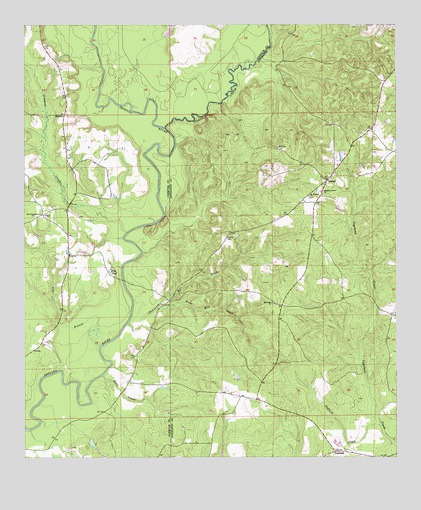
Loango, AL USGS Topographic Map
Click on map above to begin viewing in our Map Viewer.

This topographic map contains these locations and features:
Feature Name Type Latitude Longitude GNIS ID View Map
Bethesda Primitive Baptist ChurchChurchN31.2946°W86.6669°114102View Map
Chapman QuartersLocaleN31.2941°W86.6633°133378View Map
FairfieldPopulated PlaceN31.2518°W86.6455°118112View Map
Gafford CreekStreamN31.2591°W86.6297°118778View Map
Garwin CemeteryCemeteryN31.3141°W86.6833°164056View Map
Hart CreekStreamN31.2738°W86.7239°119824View Map
LoangoPopulated PlaceN31.3296°W86.6489°121936View Map
Loango Volunteer Fire DepartmentBuildingN31.3298°W86.6492°2691271View Map
MelrosePopulated PlaceN31.3491°W86.7369°156696View Map
Mitchell CemeteryCemeteryN31.3393°W86.6655°122893View Map
Mount Hored School (historical)SchoolN31.2799°W86.7114°133147View Map
Mount Pilgrim Baptist ChurchChurchN31.3257°W86.6550°123336View Map
New Providence ChurchChurchN31.3199°W86.7464°123896View Map
Pate PondReservoirN31.3042°W86.7211°124473View Map
PaulPopulated PlaceN31.3202°W86.7439°155189View Map
Paul ChurchChurchN31.3218°W86.7416°149655View Map
Paul Volunteer Fire DepartmentBuildingN31.3143°W86.7348°2691300View Map
Pigeon CreekStreamN31.3452°W86.7036°155196View Map
Pleasant Grove Baptist ChurchChurchN31.3271°W86.6500°124946View Map
Providence ChurchChurchN31.3202°W86.7322°133172View Map
Rile BranchStreamN31.2821°W86.7247°125635View Map
Robinson Mill CreekStreamN31.2885°W86.7155°125732View Map
Rose Mill CreekStreamN31.2929°W86.7061°125936View Map
Simmons CreekStreamN31.3149°W86.7164°155243View Map
Watson School (historical)SchoolN31.2835°W86.6639°133447View Map

Note: Coordinates in the location and feature list above are referenced to NAD83 datum.


Copyright (C) 2008-2025 Ryan Niemi / Sunset Dynamics ... All Rights Reserved