TopoQuest Logo
Do you find TopoQuest useful?
Help keep TopoQuest running and adding new maps/features by donating!
Bitcoin:  19c7KJd3qBynnjoSw5npx9KScwjBe4ifkT
Litecoin:  LXs6TkuXGGXo1vDsWCkWVdjQX94eUKd6ui
Home View Maps Find Maps Find Places Resources & Links


Brooks, Alabama Topographic Map

USGS Map Title: Brooks, AL
USGS Map MRC: 31086D6
DRG (GeoTIFF) Download: o31086d6.tif


Neighboring USGS Topographic Map Quads:


  Garland, AL  
31086E7
 

  McKenzie, AL  
31086E6
 

  Industry, AL  
31086E5
 

  Old Town, AL  
31086D7
 

  Brooks, AL  
31086D6
 

  Red Level, AL  
31086D5
 

  Brooklyn, AL  
31086C7
 

  Loango, AL  
31086C6
 

  River Falls, AL  
31086C5


Map MRC Location:

N32°
W87°
N32°
W86°
H8 H7 H6 H5 H4 H3 H2 H1
G8 G7 G6 G5 G4 G3 G2 G1
F8 F7 F6 F5 F4 F3 F2 F1
E8 E7 E6 E5 E4 E3 E2 E1
D8 D7 D6 D5 D4 D3 D2 D1
C8 C7 C6 C5 C4 C3 C2 C1
B8 B7 B6 B5 B4 B3 B2 B1
A8 A7 A6 A5 A4 A3 A2 A1
N31°
W87°
N31°
W86°

Brooks, AL USGS 1:24K Topographic Map Preview:
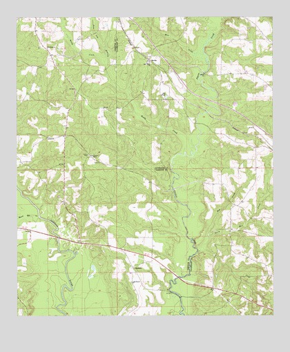
Brooks, AL USGS Topographic Map
Click on map above to begin viewing in our Map Viewer.

This topographic map contains these locations and features:
Feature Name Type Latitude Longitude GNIS ID View Map
Antioch ChurchChurchN31.4502°W86.7261°133083View Map
Antioch ChurchChurchN31.4502°W86.7347°113122View Map
Beat Volunteer Fire Department 8BuildingN31.4498°W86.7270°2691387View Map
Bold Sluice ShoalBarN31.4127°W86.6683°133370View Map
BrooksPopulated PlaceN31.4818°W86.6850°114960View Map
Brooks CemeteryCemeteryN31.4802°W86.6864°133372View Map
Brooks ChurchChurchN31.4804°W86.6861°163412View Map
Brooks Lookout TowerTowerN31.4424°W86.7152°133098View Map
CohassettPopulated PlaceN31.3949°W86.6933°156199View Map
Cohassett ChurchChurchN31.4016°W86.7077°133103View Map
Cohassett ChurchChurchN31.3960°W86.6947°133104View Map
Fergerson Lake DamDamN31.3785°W86.7166°129794View Map
Hog CreekStreamN31.4074°W86.6564°120187View Map
Lee PondReservoirN31.4669°W86.6768°152016View Map
Long Branch CemeteryCemeteryN31.3885°W86.6941°1805643View Map
Long Branch ChurchChurchN31.3891°W86.6939°121999View Map
Mancil Mill CreekStreamN31.4163°W86.7391°122247View Map
Mancill CemeteryCemeteryN31.3918°W86.6333°163418View Map
Mill CreekStreamN31.4849°W86.6586°122781View Map
Motts Bridge (historical)BridgeN31.4654°W86.6516°133419View Map
Nehoma ChurchChurchN31.4654°W86.6780°164159View Map
New Home ChurchChurchN31.4874°W86.7355°123767View Map
Pine Log BranchStreamN31.4816°W86.7075°124832View Map
Reedy CreekStreamN31.4438°W86.6683°164111View Map
Shreve DivisionCivilN31.4292°W86.7434°165719View Map
Terry Mill CreekStreamN31.4013°W86.6622°127774View Map
Terry School (historical)SchoolN31.4254°W86.6466°133443View Map

Note: Coordinates in the location and feature list above are referenced to NAD83 datum.


Copyright (C) 2008-2025 Ryan Niemi / Sunset Dynamics ... All Rights Reserved