TopoQuest Logo
Do you find TopoQuest useful?
Help keep TopoQuest running and adding new maps/features by donating!
Bitcoin:  19c7KJd3qBynnjoSw5npx9KScwjBe4ifkT
Litecoin:  LXs6TkuXGGXo1vDsWCkWVdjQX94eUKd6ui
Home View Maps Find Maps Find Places Resources & Links


Lockwoods Folly, North Carolina Topographic Map

USGS Map Title: Lockwoods Folly, NC
USGS Map MRC: 33078H2
DRG (GeoTIFF) Download: o33078h2.tif


Neighboring USGS Topographic Map Quads:


  Supply, NC  
34078A3
 

  Bolivia, NC  
34078A2
 

  Funston, NC  
34078A1
 

  Holden Beach, NC  
33078H3
 

  Lockwoods Folly, NC  
33078H2
 

  Southport, NC  
33078H1


Map MRC Location:

N34°
W79°
N34°
W78°
H8 H7 H6 H5 H4 H3 H2 H1
G8 G7 G6 G5 G4 G3 G2 G1
F8 F7 F6 F5 F4 F3 F2 F1
E8 E7 E6 E5 E4 E3 E2 E1
D8 D7 D6 D5 D4 D3 D2 D1
C8 C7 C6 C5 C4 C3 C2 C1
B8 B7 B6 B5 B4 B3 B2 B1
A8 A7 A6 A5 A4 A3 A2 A1
N33°
W79°
N33°
W78°

Lockwoods Folly, NC USGS 1:24K Topographic Map Preview:
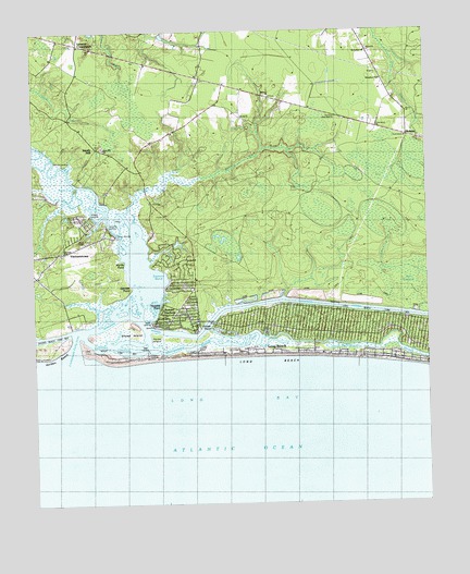
Lockwoods Folly, NC USGS Topographic Map
Click on map above to begin viewing in our Map Viewer.

This topographic map contains these locations and features:
Feature Name Type Latitude Longitude GNIS ID View Map
Ash SwampSwampN33.9371°W78.1273°980314View Map
Blue Water Point MarinaHarborN33.9160°W78.2140°2506034View Map
Dixon ChapelChurchN33.9443°W78.2331°984223View Map
Dixon LandingPopulated PlaceN33.9460°W78.2231°1019983View Map
Eastern BendBayN33.9346°W78.2094°984549View Map
Eastern ChannelChannelN33.9166°W78.2244°984551View Map
Galloway (historical)LocaleN33.9057°W78.2081°1018723View Map
Genoes PointCapeN33.9321°W78.2186°985620View Map
Gores LandingLocaleN33.9243°W78.2114°1020477View Map
Gospel ChurchChurchN33.9418°W78.2400°1004792View Map
Horse IslandIslandN33.9171°W78.2122°987098View Map
Howells PointCapeN33.9268°W78.2100°1027412View Map
Kingdom HallChurchN33.9871°W78.1386°1004794View Map
Lennon CrossroadsPopulated PlaceN33.9971°W78.2350°1006276View Map
Lockwoods CreekStreamN33.9291°W78.2086°988834View Map
Lockwoods Folly InletChannelN33.9135°W78.2344°988835View Map
Lockwoods Folly RiverStreamN33.9177°W78.2361°988836View Map
Long BeachBeachN33.9141°W78.1550°988885View Map
Mercer CutBendN33.9596°W78.2361°989732View Map
Mercer LandingPopulated PlaceN33.9652°W78.2403°1021412View Map
Mercers Mill PondStreamN33.9624°W78.2050°1004791View Map
MidwayPopulated PlaceN33.9721°W78.1280°1004793View Map
Midway ChurchChurchN33.9830°W78.1742°1004789View Map
Mill CreekStreamN33.9521°W78.2208°989901View Map
Montgomery SloughGutN33.9171°W78.1575°990155View Map
Mullet CreekStreamN33.9368°W78.2078°990786View Map
Myrtle PointCapeN33.9399°W78.2206°990834View Map
Oak IslandPopulated PlaceN33.9166°W78.1611°1848160View Map
Oak Island Fire and Rescue Station 1BuildingN33.9200°W78.1595°2638406View Map
Paris (historical)LocaleN33.9366°W78.1492°1018722View Map
Pinner PointCapeN33.9216°W78.1944°992407View Map
Robin Schusta ParkParkN33.9232°W78.1872°1004788View Map
Saint James ChurchChurchN33.9946°W78.1433°1004795View Map
Sandy HillPopulated PlaceN33.9693°W78.2289°1006363View Map
Sheep IslandIslandN33.9193°W78.2192°994612View Map
Spring CreekStreamN33.9266°W78.2294°1004790View Map
Sunset HarborLocaleN33.9213°W78.2069°1007070View Map
Sunset Harbor and Zion Hill Volunteer Fire DepartmentBuildingN33.9548°W78.2115°2638294View Map
Town of Oak IslandCivilN33.9616°W78.1455°2407020View Map
Town of VarnamtownCivilN33.9432°W78.2360°2406794View Map
Varnams LandingLocaleN33.9493°W78.2258°1004787View Map
VarnamtownPopulated PlaceN33.9357°W78.2486°1008273View Map
VarnumPopulated PlaceN33.9477°W78.2269°1005420View Map
Wildcat LandingLocaleN33.9507°W78.2306°1023244View Map
Zion Hill ChurchChurchN33.9688°W78.2267°1004796View Map

Note: Coordinates in the location and feature list above are referenced to NAD83 datum.


Copyright (C) 2008-2024 Ryan Niemi / Sunset Dynamics ... All Rights Reserved