TopoQuest Logo
Do you find TopoQuest useful?
Help keep TopoQuest running and adding new maps/features by donating!
Bitcoin:  19c7KJd3qBynnjoSw5npx9KScwjBe4ifkT
Litecoin:  LXs6TkuXGGXo1vDsWCkWVdjQX94eUKd6ui
Home View Maps Find Maps Find Places Resources & Links


Greeley, Missouri Topographic Map

USGS Map Title: Greeley, MO
USGS Map MRC: 37091E2
DRG (GeoTIFF) Download: o37091e2.tif


Neighboring USGS Topographic Map Quads:


  Howes Mill Spring, MO  
37091F3
 

  Viburnum West, MO  
37091F2
 

  Viburnum East, MO  
37091F1
 

  Stone Hill, MO  
37091E3
 

  Greeley, MO  
37091E2
 

  Oates, MO  
37091E1
 

  Loggers Lake, MO  
37091D3
 

  Bunker, MO  
37091D2
 

  Corridon, MO  
37091D1


Map MRC Location:

N38°
W92°
N38°
W91°
H8 H7 H6 H5 H4 H3 H2 H1
G8 G7 G6 G5 G4 G3 G2 G1
F8 F7 F6 F5 F4 F3 F2 F1
E8 E7 E6 E5 E4 E3 E2 E1
D8 D7 D6 D5 D4 D3 D2 D1
C8 C7 C6 C5 C4 C3 C2 C1
B8 B7 B6 B5 B4 B3 B2 B1
A8 A7 A6 A5 A4 A3 A2 A1
N37°
W92°
N37°
W91°

Greeley, MO USGS 1:24K Topographic Map Preview:
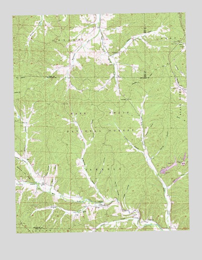
Greeley, MO USGS Topographic Map
Click on map above to begin viewing in our Map Viewer.

This topographic map contains these locations and features:
Feature Name Type Latitude Longitude GNIS ID View Map
Asher CreekStreamN37.6012°W91.1810°748619View Map
Barton CemeteryCemeteryN37.5820°W91.1307°748697View Map
Bills Creek SchoolSchoolN37.5328°W91.1465°747900View Map
Brushy Creek Mill Reservoir DamDamN37.5400°W91.1268°763816View Map
Brushy Creek MineMineN37.5381°W91.1287°753457View Map
Brushy Creek Mine Water Clarification DamDamN37.5284°W91.1368°764060View Map
Brushy Creek Mine Water LakeReservoirN37.5288°W91.1343°764061View Map
Brushy Creek Tailings DamDamN37.5350°W91.1435°764775View Map
Bucksnort ForkStreamN37.6159°W91.1874°749094View Map
BuickPopulated PlaceN37.6070°W91.1268°749103View Map
Buick Lookout TowerTowerN37.6081°W91.1285°755019View Map
Buick School (historical)SchoolN37.6075°W91.1340°736631View Map
Callahan CemeteryCemeteryN37.5095°W91.1657°749160View Map
Camden CemeteryCemeteryN37.5959°W91.1762°749165View Map
Crossville BranchStreamN37.5273°W91.2340°749540View Map
Crossville ChurchChurchN37.5281°W91.2310°754063View Map
Elm Spring SchoolSchoolN37.6067°W91.1837°747897View Map
GreeleyPopulated PlaceN37.5150°W91.1871°750131View Map
Greeley ChurchChurchN37.5117°W91.2018°750132View Map
Greeley School (historical)SchoolN37.5145°W91.1865°730433View Map
Henpeck CreekStreamN37.5178°W91.1971°750293View Map
Hodge HollowValleyN37.5125°W91.1690°750349View Map
Jones HollowValleyN37.5295°W91.2304°750543View Map
Lick CreekStreamN37.5239°W91.1424°750710View Map
Low GapGapN37.5756°W91.1685°750874View Map
McMurtrey CreekStreamN37.5167°W91.1865°751008View Map
McMurtrey SchoolSchoolN37.5639°W91.2068°747899View Map
Moore BranchStreamN37.5231°W91.2251°751147View Map
New Harmony ChurchChurchN37.6025°W91.1732°751282View Map
New Zion Church (historical)ChurchN37.5884°W91.1746°747898View Map
Number 48 LakeReservoirN37.5419°W91.1277°763817View Map
Parker BranchStreamN37.5398°W91.2410°751497View Map
Radford BranchStreamN37.5273°W91.2340°751791View Map
Radford CemeteryCemeteryN37.5634°W91.2451°751792View Map
Smalls CreekStreamN37.5070°W91.1615°752210View Map
Spring BranchStreamN37.5409°W91.1543°752295View Map
Spring HollowValleyN37.5175°W91.1757°752317View Map
Stricklin BranchStreamN37.5437°W91.1562°752397View Map
Sugar CreekStreamN37.5289°W91.2496°753975View Map
Tarpit HollowValleyN37.5275°W91.1924°752490View Map
Walnut HollowValleyN37.5534°W91.1565°752746View Map
Warren ValleyValleyN37.5492°W91.1979°752767View Map

Note: Coordinates in the location and feature list above are referenced to NAD83 datum.


Copyright (C) 2008-2025 Ryan Niemi / Sunset Dynamics ... All Rights Reserved