TopoQuest Logo
Do you find TopoQuest useful?
Help keep TopoQuest running and adding new maps/features by donating!
Bitcoin:  19c7KJd3qBynnjoSw5npx9KScwjBe4ifkT
Litecoin:  LXs6TkuXGGXo1vDsWCkWVdjQX94eUKd6ui
Home View Maps Find Maps Find Places Resources & Links


London Mills, Illinois Topographic Map

USGS Map Title: London Mills, IL
USGS Map MRC: 40090F3
DRG (GeoTIFF) Download: o40090f3.tif


Neighboring USGS Topographic Map Quads:


  Abingdon, IL  
40090G4
 

  DeLong, IL  
40090G3
 

  Maquon, IL  
40090G2
 

  Avon, IL  
40090F4
 

  London Mills, IL  
40090F3
 

  Fairview, IL  
40090F2
 

  Bushnell East, IL  
40090E4
 

  Blyton, IL  
40090E3
 

  Fiatt, IL  
40090E2


Map MRC Location:

N41°
W91°
N41°
W90°
H8 H7 H6 H5 H4 H3 H2 H1
G8 G7 G6 G5 G4 G3 G2 G1
F8 F7 F6 F5 F4 F3 F2 F1
E8 E7 E6 E5 E4 E3 E2 E1
D8 D7 D6 D5 D4 D3 D2 D1
C8 C7 C6 C5 C4 C3 C2 C1
B8 B7 B6 B5 B4 B3 B2 B1
A8 A7 A6 A5 A4 A3 A2 A1
N40°
W91°
N40°
W90°

London Mills, IL USGS 1:24K Topographic Map Preview:
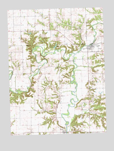
London Mills, IL USGS Topographic Map
Click on map above to begin viewing in our Map Viewer.

This topographic map contains these locations and features:
Feature Name Type Latitude Longitude GNIS ID View Map
Camp WildernessLocaleN40.7123°W90.3196°405511View Map
Cedar CreekStreamN40.7045°W90.2887°405736View Map
Coal CreekStreamN40.6323°W90.3012°406291View Map
Council Corner School (historical)SchoolN40.6270°W90.3482°1719444View Map
EllisvillePopulated PlaceN40.6267°W90.3051°407909View Map
Ellisville CemeteryCemeteryN40.6313°W90.3049°1773322View Map
Ellisville Post OfficePost OfficeN40.6267°W90.3052°2788376View Map
Ellisville StationLocaleN40.6487°W90.2810°407910View Map
Fair Mound School (historical)SchoolN40.7287°W90.2721°1719632View Map
Flake CemeteryCemeteryN40.6637°W90.3465°408427View Map
Flake School (historical)SchoolN40.6495°W90.3440°1719448View Map
Gooseneck School (historical)SchoolN40.7428°W90.3387°1719642View Map
Haney HillSummitN40.6603°W90.3290°409739View Map
Hazel Ridge School (historical)SchoolN40.6409°W90.2718°1719457View Map
Heartley CemeteryCemeteryN40.6856°W90.3251°410005View Map
Indian FordCrossingN40.6973°W90.2898°1802226View Map
Indian Ford Bridge (historical)BridgeN40.6973°W90.2898°425031View Map
Knox Company Conservation Club LakeReservoirN40.7262°W90.3463°1692103View Map
Knox Company Conservation Club Lake DamDamN40.7267°W90.3468°1692102View Map
Lake RobertsReservoirN40.7126°W90.3136°416761View Map
Lake Roberts DamDamN40.7103°W90.3146°1691207View Map
Landon CemeteryCemeteryN40.6631°W90.3068°411795View Map
Little Coal CreekStreamN40.6462°W90.2771°412305View Map
London MillsPopulated PlaceN40.7106°W90.2662°412531View Map
London Mills Bridge (historical)BridgeN40.7137°W90.2662°1802164View Map
London Mills Community Fire Protection DistrictBuildingN40.7088°W90.2658°2640694View Map
London Mills School (historical)SchoolN40.7128°W90.2671°1802230View Map
Mount Joy School (historical)SchoolN40.6559°W90.3137°1802233View Map
Oak Mound School (historical)SchoolN40.6700°W90.2687°1719478View Map
Pleasant Hill CemeteryCemeteryN40.6911°W90.3100°415823View Map
Pleasant Hill School (historical)SchoolN40.6848°W90.3093°1802237View Map
Pleasant Ridge (historical)Populated PlaceN40.6931°W90.3568°1802238View Map
Pleasant Ridge School (historical)SchoolN40.6928°W90.3562°1719485View Map
Pleasant Valley School (historical)SchoolN40.7356°W90.3679°1719685View Map
South Grove School (historical)SchoolN40.7289°W90.3101°1719696View Map
Swegle CreekStreamN40.6923°W90.2857°419482View Map
Township of EllisvilleCivilN40.6629°W90.3098°428958View Map
Township of Young HickoryCivilN40.6697°W90.2528°429973View Map
Troy (historical)Populated PlaceN40.6909°W90.3351°1802165View Map
Troy School (historical)SchoolN40.6792°W90.3376°1719509View Map
Village of EllisvilleCivilN40.6273°W90.3060°2398810View Map
Village of London MillsCivilN40.7106°W90.2661°2398469View Map

Note: Coordinates in the location and feature list above are referenced to NAD83 datum.


Copyright (C) 2008-2024 Ryan Niemi / Sunset Dynamics ... All Rights Reserved