TopoQuest Logo
Do you find TopoQuest useful?
Help keep TopoQuest running and adding new maps/features by donating!
Bitcoin:  19c7KJd3qBynnjoSw5npx9KScwjBe4ifkT
Litecoin:  LXs6TkuXGGXo1vDsWCkWVdjQX94eUKd6ui
Home View Maps Find Maps Find Places Resources & Links


Long Island, Illinois Topographic Map

USGS Map Title: Long Island, IL
USGS Map MRC: 40091A4
DRG (GeoTIFF) Download: o40091a4.tif


Neighboring USGS Topographic Map Quads:


  Canton, MO  
40091B5
 

  Lima, IL  
40091B4
 

  Tioga, IL  
40091B3
 

  La Grange, MO  
40091A5
 

  Long Island, IL  
40091A4
 

  Mendon, IL  
40091A3
 

  Maywood, MO  
39091H5
 

  Quincy West, IL  
39091H4
 

  Quincy East, IL  
39091H3


Map MRC Location:

N41°
W92°
N41°
W91°
H8 H7 H6 H5 H4 H3 H2 H1
G8 G7 G6 G5 G4 G3 G2 G1
F8 F7 F6 F5 F4 F3 F2 F1
E8 E7 E6 E5 E4 E3 E2 E1
D8 D7 D6 D5 D4 D3 D2 D1
C8 C7 C6 C5 C4 C3 C2 C1
B8 B7 B6 B5 B4 B3 B2 B1
A8 A7 A6 A5 A4 A3 A2 A1
N40°
W92°
N40°
W91°

Long Island, IL USGS 1:24K Topographic Map Preview:
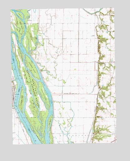
Long Island, IL USGS Topographic Map
Click on map above to begin viewing in our Map Viewer.

This topographic map contains these locations and features:
Feature Name Type Latitude Longitude GNIS ID View Map
Barns IslandIslandN40.1103°W91.4877°1720497View Map
Bear Creek Public Use AreaParkN40.1139°W91.4818°1720498View Map
Blickhan Landing AreaAirportN40.0083°W91.3786°427720View Map
Bowles School (historical)SchoolN40.0017°W91.3782°404740View Map
Campbell FarmsLocaleN40.0472°W91.3928°2568289View Map
Campbell QuarryMineN40.0509°W91.3952°1837318View Map
Canton ChuteChannelN40.0767°W91.4735°405561View Map
Chatton IslandIslandN40.1195°W91.4890°1720509View Map
Corner SloughGutN40.0884°W91.4704°406598View Map
Dillon IslandIslandN40.1095°W91.4940°407224View Map
Fairview School (historical)SchoolN40.1114°W91.4402°408218View Map
Flannigan IslandIslandN40.0439°W91.4615°408431View Map
Gentry School (historical)SchoolN40.0092°W91.4435°408946View Map
Great River National Wildlife RefugeParkN40.0466°W91.4775°2765321View Map
Harkness BranchGutN40.0142°W91.4429°409782View Map
Hughes School (historical)SchoolN40.0812°W91.3938°410663View Map
Indian Grave LakeLakeN40.0974°W91.4683°410855View Map
Indian Grave School (historical)SchoolN40.0856°W91.4577°410856View Map
Island Number 419IslandN40.0731°W91.4915°425050View Map
Jenkins CreekStreamN40.1095°W91.3949°411087View Map
La GrangePopulated PlaceN40.0428°W91.4977°735680View Map
La Grange IslandIslandN40.0423°W91.4888°411640View Map
La Grange Police DepartmentBuildingN40.0431°W91.4994°2752542View Map
La Grange Post OfficePost OfficeN40.0441°W91.4977°2783123View Map
LeSueur's PortLocaleN40.0578°W91.4957°732843View Map
Libby IslandIslandN40.0198°W91.4554°1720541View Map
Long IslandIslandN40.0539°W91.4757°412570View Map
Long Island LakeLakeN40.0421°W91.4737°2761578View Map
Long Island LakeIslandN40.0421°W91.4737°2747179View Map
Main DitchCanalN40.1095°W91.4527°412858View Map
Oyster BranchStreamN40.0245°W91.4918°723931View Map
Rock and Ursa Creek Diversion CanalCanalN40.0462°W91.4274°416788View Map
Rock CreekStreamN40.0456°W91.3974°416800View Map
Rock CreekPopulated PlaceN40.0459°W91.3996°423125View Map
Rock Creek School (historical)SchoolN40.0528°W91.3960°416810View Map
Ruddell School (historical)SchoolN40.1114°W91.3988°417026View Map
Schnelle Airport (historical)AirportN40.0987°W91.3974°427885View Map
Shandrew IslandIslandN40.0706°W91.4749°418278View Map
Smoots ChuteGutN40.0980°W91.4922°2761577View Map
Township of UrsaCivilN40.0771°W91.4168°429857View Map
Ursa CreekStreamN40.0762°W91.3960°420184View Map
Wyaconda RiverStreamN40.0598°W91.4957°735929View Map

Note: Coordinates in the location and feature list above are referenced to NAD83 datum.


Copyright (C) 2008-2024 Ryan Niemi / Sunset Dynamics ... All Rights Reserved