TopoQuest Logo
Do you find TopoQuest useful?
Help keep TopoQuest running and adding new maps/features by donating!
Bitcoin:  19c7KJd3qBynnjoSw5npx9KScwjBe4ifkT
Litecoin:  LXs6TkuXGGXo1vDsWCkWVdjQX94eUKd6ui
Home View Maps Find Maps Find Places Resources & Links


Mendon, Illinois Topographic Map

USGS Map Title: Mendon, IL
USGS Map MRC: 40091A3
DRG (GeoTIFF) Download: o40091a3.tif


Neighboring USGS Topographic Map Quads:


  Lima, IL  
40091B4
 

  Tioga, IL  
40091B3
 

  Loraine, IL  
40091B2
 

  Long Island, IL  
40091A4
 

  Mendon, IL  
40091A3
 

  Coatsburg, IL  
40091A2
 

  Quincy West, IL  
39091H4
 

  Quincy East, IL  
39091H3
 

  Columbus, IL  
39091H2


Map MRC Location:

N41°
W92°
N41°
W91°
H8 H7 H6 H5 H4 H3 H2 H1
G8 G7 G6 G5 G4 G3 G2 G1
F8 F7 F6 F5 F4 F3 F2 F1
E8 E7 E6 E5 E4 E3 E2 E1
D8 D7 D6 D5 D4 D3 D2 D1
C8 C7 C6 C5 C4 C3 C2 C1
B8 B7 B6 B5 B4 B3 B2 B1
A8 A7 A6 A5 A4 A3 A2 A1
N40°
W92°
N40°
W91°

Mendon, IL USGS 1:24K Topographic Map Preview:
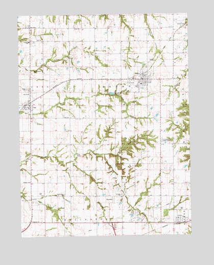
Mendon, IL USGS Topographic Map
Click on map above to begin viewing in our Map Viewer.

This topographic map contains these locations and features:
Feature Name Type Latitude Longitude GNIS ID View Map
Adams County Ambulance Emergency Medical ServicesBuildingN40.0879°W91.2846°2673979View Map
Adams County FairgroundParkN40.0537°W91.2696°1720494View Map
BloomfieldPopulated PlaceN40.0209°W91.3071°422477View Map
Booth CemeteryCemeteryN40.0248°W91.3613°404699View Map
Brick School (historical)SchoolN40.1173°W91.2793°404844View Map
Center School (historical)SchoolN40.0673°W91.3051°405815View Map
Cramm Landing Area (historical)AirportN40.1000°W91.2835°427529View Map
Denson CemeteryCemeteryN40.0839°W91.3701°407133View Map
Dry BranchStreamN40.0431°W91.3357°422218View Map
Elm Grove School (historical)SchoolN40.0412°W91.2715°407926View Map
First Congregational ChurchChurchN40.0898°W91.2835°1837321View Map
FowlerPopulated PlaceN40.0078°W91.2585°408606View Map
Fowler Post OfficePost OfficeN40.0071°W91.2591°1785280View Map
Franklin CemeteryCemeteryN40.1175°W91.3290°408661View Map
Franklin School (historical)SchoolN40.1184°W91.3254°408687View Map
Golden SchoolSchoolN40.0975°W91.3671°409123View Map
Greenfield Elementary SchoolSchoolN40.1100°W91.3674°1720528View Map
Jug LakeReservoirN40.0118°W91.2934°1692577View Map
Jug Lake DamDamN40.0134°W91.2951°1692576View Map
Keith CemeteryCemeteryN40.1111°W91.3579°411350View Map
MarcellinePopulated PlaceN40.1181°W91.3674°412985View Map
MendonPopulated PlaceN40.0884°W91.2838°413396View Map
Mendon Elementary SchoolSchoolN40.0853°W91.2849°1785311View Map
Mendon Post OfficePost OfficeN40.0879°W91.2839°2788749View Map
Mendon Volunteer Fire AssociationBuildingN40.0884°W91.2845°2640892View Map
Mount Pleasant School (historical)SchoolN40.0600°W91.3382°414066View Map
Moyer CemeteryCemeteryN40.0287°W91.2626°1984975View Map
New Providence CemeteryCemeteryN40.0934°W91.3663°414454View Map
Saint Edward ChurchChurchN40.0867°W91.2838°1837332View Map
Saint Joseph CemeteryCemeteryN40.0234°W91.3013°417431View Map
Sand BranchStreamN40.0464°W91.3129°417929View Map
Stahl CemeteryCemeteryN40.0153°W91.2587°419025View Map
Standard School (historical)SchoolN40.0137°W91.3440°419032View Map
Star School (historical)SchoolN40.0881°W91.3218°419050View Map
Stone Family CemeteryCemeteryN40.0675°W91.3426°419161View Map
Township of MendonCivilN40.0890°W91.2991°429353View Map
Union School (historical)SchoolN40.0381°W91.3685°420113View Map
Unity High SchoolSchoolN40.0887°W91.2907°1785361View Map
UrsaPopulated PlaceN40.0748°W91.3674°420183View Map
Ursa Christian ChurchChurchN40.0773°W91.3674°1983612View Map
Ursa Fire Protection DistrictBuildingN40.0739°W91.3664°2640265View Map
Ursa Post OfficePost OfficeN40.0753°W91.3670°2788348View Map
Village of MendonCivilN40.0894°W91.2858°2399313View Map
Village of UrsaCivilN40.0742°W91.3728°2400033View Map
Wesley Chapel CemeteryCemeteryN40.0239°W91.3435°420771View Map
Zion United Church of ChristChurchN40.0728°W91.3679°1983613View Map

Note: Coordinates in the location and feature list above are referenced to NAD83 datum.


Copyright (C) 2008-2025 Ryan Niemi / Sunset Dynamics ... All Rights Reserved