TopoQuest Logo
Do you find TopoQuest useful?
Help keep TopoQuest running and adding new maps/features by donating!
Bitcoin:  19c7KJd3qBynnjoSw5npx9KScwjBe4ifkT
Litecoin:  LXs6TkuXGGXo1vDsWCkWVdjQX94eUKd6ui
Home View Maps Find Maps Find Places Resources & Links


Canton, Missouri Topographic Map

USGS Map Title: Canton, MO
USGS Map MRC: 40091B5
DRG (GeoTIFF) Download: o40091b5.tif


Neighboring USGS Topographic Map Quads:


  Saint Patrick, MO  
40091C6
 

  Kahoka SE, MO  
40091C5
 

  Warsaw, IL  
40091C4
 

  Benjamin, MO  
40091B6
 

  Canton, MO  
40091B5
 

  Lima, IL  
40091B4
 

  Monticello, MO  
40091A6
 

  La Grange, MO  
40091A5
 

  Long Island, IL  
40091A4


Map MRC Location:

N41°
W92°
N41°
W91°
H8 H7 H6 H5 H4 H3 H2 H1
G8 G7 G6 G5 G4 G3 G2 G1
F8 F7 F6 F5 F4 F3 F2 F1
E8 E7 E6 E5 E4 E3 E2 E1
D8 D7 D6 D5 D4 D3 D2 D1
C8 C7 C6 C5 C4 C3 C2 C1
B8 B7 B6 B5 B4 B3 B2 B1
A8 A7 A6 A5 A4 A3 A2 A1
N40°
W92°
N40°
W91°

Canton, MO USGS 1:24K Topographic Map Preview:
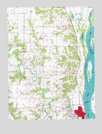
Canton, MO USGS Topographic Map
Click on map above to begin viewing in our Map Viewer.

This topographic map contains these locations and features:
Feature Name Type Latitude Longitude GNIS ID View Map
Artesian BranchStreamN40.1734°W91.5149°713408View Map
AugustaLocaleN40.2478°W91.5415°732808View Map
Augusta SchoolSchoolN40.2489°W91.5438°713483View Map
Baxter LakeReservoirN40.2255°W91.5402°760549View Map
Baxter Lake DamDamN40.2267°W91.5385°760548View Map
Baxter PondsLakeN40.2386°W91.5316°735500View Map
Bland SchoolSchoolN40.1706°W91.5279°714356View Map
Brownsville IslandIslandN40.1756°W91.5015°404990View Map
Bruns LakeReservoirN40.1767°W91.5402°760528View Map
Buck Doe Run Creek Watershed Dam Number 43DamN40.1517°W91.5402°762032View Map
Buck RunStreamN40.1403°W91.5157°735538View Map
Buck-Doe Run Creeks Watershed Lake Number 39ReservoirN40.1934°W91.5285°760526View Map
Buck-Doe Run Creeks Watershed Lake Number 39 DamDamN40.1934°W91.5285°760525View Map
Buck-Doe Run Creeks Watershed Number 5 DamDamN40.1934°W91.5435°760521View Map
Buck-Doe Run Creeks Watershed Structure Number 6 DamDamN40.1767°W91.5402°760527View Map
Buck-Doe Run Watershed Lake Number 25ReservoirN40.2281°W91.5444°760503View Map
Buck-Doe Run Watershed Structure Number 25 DamDamN40.2284°W91.5452°760502View Map
Buck-Doe Run Watershed Structure Number 27a DamDamN40.1767°W91.5568°762026View Map
Buck-Doe Run Watershed Structure Number 27b DamDamN40.1784°W91.5568°762742View Map
Buck-Doe Run Watershed Structure Number 3 DamDamN40.2467°W91.5635°760496View Map
Buck-Doe Run Watershed Structure Number 35 DamDamN40.2467°W91.5418°760500View Map
Buck-Doe Run Watershed Structure Number 38 DamDamN40.2167°W91.5368°760523View Map
Buck-Doe Run Watershed Structure Number 42 DamDamN40.1550°W91.5385°762029View Map
Buena Vista Church (historical)ChurchN40.2287°W91.5721°732809View Map
Buena Vista SchoolSchoolN40.2284°W91.5729°735542View Map
Canton FerryCrossingN40.1345°W91.5085°405563View Map
Canton FerryLocaleN40.1350°W91.5127°715371View Map
Canton Police DepartmentBuildingN40.1308°W91.5198°2752112View Map
Canton Post OfficePost OfficeN40.1304°W91.5204°2779477View Map
Canton R - V Fire Protection DistrictBuildingN40.1312°W91.5168°2621211View Map
Carnegy Mill (historical)LocaleN40.1420°W91.5996°732810View Map
City of CantonCivilN40.1295°W91.5267°2393734View Map
Clark LakeReservoirN40.1650°W91.5702°762028View Map
Clark Lake DamDamN40.1650°W91.5702°762027View Map
College HillSummitN40.1306°W91.5303°731994View Map
Crooked CreekStreamN40.1806°W91.5932°716514View Map
Culver Stockton CollegeSchoolN40.1306°W91.5304°735572View Map
Doe RunStreamN40.2279°W91.5215°735579View Map
Fair Oak SchoolSchoolN40.2292°W91.6238°735610View Map
Forest Grove CemeteryCemeteryN40.1352°W91.5358°718080View Map
Gregory CemeteryCemeteryN40.2184°W91.5282°718862View Map
Hardin CemeteryCemeteryN40.2128°W91.5443°719087View Map
Hardin SchoolSchoolN40.2167°W91.5299°719089View Map
Hardy Bar IslandIslandN40.2092°W91.5029°409779View Map
Hazel Grove SchoolSchoolN40.1400°W91.5849°719292View Map
Higbee LakeReservoirN40.2463°W91.5633°760497View Map
KQCA-FM (Canton)TowerN40.1259°W91.5285°759130View Map
LauraPopulated PlaceN40.2214°W91.6015°755596View Map
Lewis County Number 36 DamDamN40.2434°W91.5452°760499View Map
Lewis County Number 37 DamDamN40.2400°W91.5452°760498View Map
Lloyd Lake NorthReservoirN40.1550°W91.5385°762030View Map
Lloyd Lake SouthReservoirN40.1517°W91.5402°762033View Map
Lock and Dam 20DamN40.1442°W91.5099°412464View Map
Lock and Dam Number TwentyDamN40.1437°W91.5127°721373View Map
Long LakeReservoirN40.2167°W91.5368°760524View Map
Long PondLakeN40.2418°W91.5195°721554View Map
Marks LakeReservoirN40.2034°W91.5885°761812View Map
Marks Lake DamDamN40.2034°W91.5885°761811View Map
McCullough South DamReservoirN40.1942°W91.5456°760522View Map
Melrose SchoolSchoolN40.1745°W91.5638°722208View Map
MeyerPopulated PlaceN40.1478°W91.5035°413460View Map
Mount Moriah ChurchChurchN40.1720°W91.5996°735733View Map
O'Farre LakeLakeN40.2165°W91.5169°735756View Map
Oak Bluff CemeteryCemeteryN40.1295°W91.5358°732811View Map
Pleasant Grove SchoolSchoolN40.2006°W91.5990°724511View Map
Pool 20ReservoirN40.1477°W91.5102°2746782View Map
Prospect CemeteryCemeteryN40.1714°W91.6207°724950View Map
Round PondLakeN40.2417°W91.5258°725610View Map
SantuzzaPopulated PlaceN40.2059°W91.5343°755661View Map
Schlotter LakeReservoirN40.2476°W91.5433°760501View Map
Shiloh ChurchChurchN40.2350°W91.5332°726375View Map
The Adwell Corporation Airport (historical)AirportN40.1500°W91.5002°427537View Map
Township of CantonCivilN40.1745°W91.5602°766892View Map
TullyPopulated PlaceN40.1378°W91.5224°732812View Map
Tully IslandIslandN40.1812°W91.5071°419915View Map
Uhlmeyer LakeReservoirN40.1882°W91.6006°762741View Map
Uhlmeyer Lake DamDamN40.1884°W91.6002°762740View Map
White IslandIslandN40.1678°W91.5088°421044View Map
Willer LakeReservoirN40.2178°W91.5709°762739View Map
Willer Lake DamDamN40.2184°W91.5718°762738View Map
Willer Lake Section 20ReservoirN40.2434°W91.5918°762737View Map
Willer Lake Section 20 DamDamN40.2434°W91.5918°762736View Map
Willer Lake Section 32ReservoirN40.2154°W91.5768°762025View Map
Willer Lake Section 32 DamDamN40.2150°W91.5802°762024View Map
Zahn CemeteryCemeteryN40.1261°W91.5265°729218View Map

Note: Coordinates in the location and feature list above are referenced to NAD83 datum.


Copyright (C) 2008-2024 Ryan Niemi / Sunset Dynamics ... All Rights Reserved