TopoQuest Logo
Do you find TopoQuest useful?
Help keep TopoQuest running and adding new maps/features by donating!
Bitcoin:  19c7KJd3qBynnjoSw5npx9KScwjBe4ifkT
Litecoin:  LXs6TkuXGGXo1vDsWCkWVdjQX94eUKd6ui
Home View Maps Find Maps Find Places Resources & Links


Maywood, Missouri Topographic Map

USGS Map Title: Maywood, MO
USGS Map MRC: 39091H5
DRG (GeoTIFF) Download: o39091h5.tif


Neighboring USGS Topographic Map Quads:


  Monticello, MO  
40091A6
 

  La Grange, MO  
40091A5
 

  Long Island, IL  
40091A4
 

  Durham, MO  
39091H6
 

  Maywood, MO  
39091H5
 

  Quincy West, IL  
39091H4
 

  Philadelphia, MO  
39091G6
 

  Palmyra, MO  
39091G5
 

  Quincy SW, MO  
39091G4


Map MRC Location:

N40°
W92°
N40°
W91°
H8 H7 H6 H5 H4 H3 H2 H1
G8 G7 G6 G5 G4 G3 G2 G1
F8 F7 F6 F5 F4 F3 F2 F1
E8 E7 E6 E5 E4 E3 E2 E1
D8 D7 D6 D5 D4 D3 D2 D1
C8 C7 C6 C5 C4 C3 C2 C1
B8 B7 B6 B5 B4 B3 B2 B1
A8 A7 A6 A5 A4 A3 A2 A1
N39°
W92°
N39°
W91°

Maywood, MO USGS 1:24K Topographic Map Preview:
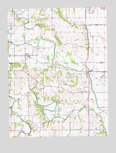
Maywood, MO USGS Topographic Map
Click on map above to begin viewing in our Map Viewer.

This topographic map contains these locations and features:
Feature Name Type Latitude Longitude GNIS ID View Map
Bethel BranchStreamN39.8934°W91.5610°732958View Map
Bimson DamDamN39.9350°W91.6018°762040View Map
C B Keller LakeReservoirN39.9161°W91.5447°761112View Map
Franklin SchoolSchoolN39.8817°W91.5368°735622View Map
Grassy CreekStreamN39.9112°W91.6149°735631View Map
Haerr Field (historical)AirportN39.9424°W91.5133°758965View Map
Hebron CemeteryCemeteryN39.9400°W91.6221°719331View Map
Hebron Church (historical)ChurchN39.9400°W91.6227°732933View Map
Hebron School (historical)SchoolN39.9392°W91.6215°732934View Map
Keller Lake DamDamN39.9150°W91.5452°761111View Map
Lavingon DamDamN39.9267°W91.6235°762039View Map
Liberty CemeteryCemeteryN39.9975°W91.5685°720964View Map
Liberty Church (historical)ChurchN39.9967°W91.5699°732836View Map
Liberty SchoolSchoolN39.9981°W91.5682°732837View Map
Maple LakeLakeN39.9521°W91.5635°732838View Map
MaywoodPopulated PlaceN39.9542°W91.6032°735714View Map
Maywood CemeteryCemeteryN39.9598°W91.5885°722020View Map
Maywood Post OfficePost OfficeN39.9544°W91.6001°2783151View Map
Middle Fabius RiverStreamN39.9717°W91.5815°722271View Map
North Fabius RiverStreamN39.8992°W91.5060°723446View Map
Oakview SchoolSchoolN39.8839°W91.5852°735762View Map
Olivet ChurchChurchN39.9184°W91.5332°723815View Map
R - 4 Fire Protection District Station 2 MaywoodBuildingN39.9540°W91.6040°2621322View Map
Scott School (historical)SchoolN39.9223°W91.6238°732931View Map
Shannon SchoolSchoolN39.9209°W91.5340°735849View Map
South Fabius RiverStreamN39.8992°W91.5060°726721View Map
Sudduth School (historical)SchoolN39.9234°W91.5902°732932View Map
Sunrise CemeteryCemeteryN39.9209°W91.6235°727319View Map
TaylorPopulated PlaceN39.9381°W91.5238°741313View Map
Taylor Post OfficePost OfficeN39.9379°W91.5246°2783132View Map
Township of FabiusCivilN39.8828°W91.5342°766999View Map
Troublesome CreekStreamN39.9048°W91.6213°735890View Map
Walnut Grove SchoolSchoolN39.9648°W91.5227°732839View Map

Note: Coordinates in the location and feature list above are referenced to NAD83 datum.


Copyright (C) 2008-2024 Ryan Niemi / Sunset Dynamics ... All Rights Reserved