TopoQuest Logo
Do you find TopoQuest useful?
Help keep TopoQuest running and adding new maps/features by donating!
Bitcoin:  19c7KJd3qBynnjoSw5npx9KScwjBe4ifkT
Litecoin:  LXs6TkuXGGXo1vDsWCkWVdjQX94eUKd6ui
Home View Maps Find Maps Find Places Resources & Links


Longview Heights, Texas Topographic Map

USGS Map Title: Longview Heights, TX
USGS Map MRC: 32094E6
DRG (GeoTIFF) Download: o32094e6.tif


Neighboring USGS Topographic Map Quads:


  Glenwood, TX  
32094F7
 

  Ashland, TX  
32094F6
 

  Harleton, TX  
32094F5
 

  White Oak, TX  
32094E7
 

  Longview Heights, TX  
32094E6
 

  Hallsville, TX  
32094E5
 

  Kilgore NE, TX  
32094D7
 

  Lakeport, TX  
32094D6
 

  Easton, TX  
32094D5


Map MRC Location:

N33°
W95°
N33°
W94°
H8 H7 H6 H5 H4 H3 H2 H1
G8 G7 G6 G5 G4 G3 G2 G1
F8 F7 F6 F5 F4 F3 F2 F1
E8 E7 E6 E5 E4 E3 E2 E1
D8 D7 D6 D5 D4 D3 D2 D1
C8 C7 C6 C5 C4 C3 C2 C1
B8 B7 B6 B5 B4 B3 B2 B1
A8 A7 A6 A5 A4 A3 A2 A1
N32°
W95°
N32°
W94°

Longview Heights, TX USGS 1:24K Topographic Map Preview:
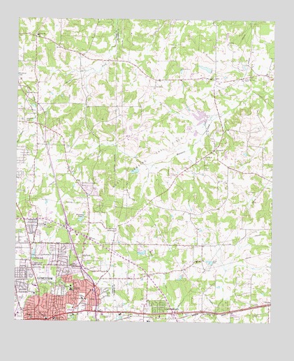
Longview Heights, TX USGS Topographic Map
Click on map above to begin viewing in our Map Viewer.

This topographic map contains these locations and features:
Feature Name Type Latitude Longitude GNIS ID View Map
Akin ParkParkN32.5238°W94.7352°2028869View Map
Alpine CemeteryCemeteryN32.5549°W94.7133°1329432View Map
Alpine ChurchChurchN32.5579°W94.7188°1329433View Map
Bramlette Elementary SchoolSchoolN32.5107°W94.7397°2005536View Map
Bramlette SchoolSchoolN32.5115°W94.7405°1331190View Map
Clement Lake Number 1ReservoirN32.5851°W94.6585°1861310View Map
Clements Dam Number 1DamN32.5851°W94.6585°1861309View Map
Clements Dam Number 4DamN32.5801°W94.6652°1861307View Map
Clements Lake Number 4ReservoirN32.5805°W94.6662°1861308View Map
Daniels SchoolSchoolN32.5007°W94.7347°1334037View Map
Doris McQueen Primary SchoolSchoolN32.5707°W94.7405°2005540View Map
East Side AirportAirportN32.5085°W94.7002°1387102View Map
First Assembly of God ChurchChurchN32.5332°W94.7285°2019657View Map
First United Pentecostal ChurchChurchN32.5165°W94.7091°2019543View Map
Forest Hill ChurchChurchN32.5965°W94.6830°1336024View Map
Forest Park Junior High SchoolSchoolN32.5135°W94.7227°1336036View Map
Forest Park Middle SchoolSchoolN32.5126°W94.7238°2005542View Map
Franklin LakeReservoirN32.6046°W94.6575°1861306View Map
Franklin Lake DamDamN32.6035°W94.6569°1861305View Map
Free Holiness ChurchChurchN32.5374°W94.7013°1336175View Map
Good Shepherd Medical CenterHospitalN32.5008°W94.7305°1336701View Map
Grace Hill CemeteryCemeteryN32.5010°W94.7477°1336772View Map
Growing Valley Baptist ChurchChurchN32.5038°W94.7397°2019553View Map
Guthrie ParkParkN32.5126°W94.7408°2028293View Map
Harleton Receiving StationLocaleN32.6010°W94.6410°1384389View Map
Hebron ChurchChurchN32.6007°W94.6544°1337555View Map
Hope CemeteryCemeteryN32.5029°W94.6333°1338046View Map
Ingram ParkParkN32.5149°W94.7241°2029158View Map
Johnston LakeReservoirN32.5281°W94.7411°1338824View Map
Judson Metro Volunteer Fire DepartmentBuildingN32.6110°W94.7473°2655574View Map
KFRO-AM (Longview)TowerN32.5021°W94.7035°1387862View Map
La Grones ChurchChurchN32.5707°W94.6524°1339323View Map
LansingPopulated PlaceN32.5079°W94.6263°1378560View Map
Lewis ChapelChurchN32.5396°W94.7391°1339847View Map
Lily Hill CemeteryCemeteryN32.5632°W94.6580°1339925View Map
Lily Hill ChurchChurchN32.5682°W94.6583°1339926View Map
Little LakeReservoirN32.5249°W94.6550°1340130View Map
Lobo StadiumParkN32.5460°W94.7422°2027775View Map
Locust Grove plantationLocaleN32.5407°W94.6827°2032075View Map
LongviewPopulated PlaceN32.5007°W94.7405°1374716View Map
Longview Fire Department / Emergency Medical Services Station 6BuildingN32.5207°W94.7421°2655688View Map
Longview Fire Department 2 - Hazmat WMD HeadQuartersBuildingN32.5098°W94.7099°2655693View Map
Longview HeightsPopulated PlaceN32.5060°W94.6797°1340542View Map
Longview Missionary Baptist ChurchChurchN32.5415°W94.7338°2019557View Map
Longview Police Department Beat 40BuildingN32.5059°W94.7299°2751454View Map
Longview Regional Medical CenterHospitalN32.5330°W94.7302°2015835View Map
Macedonia ChurchChurchN32.5251°W94.6622°1340801View Map
Mason Springs ChurchChurchN32.5038°W94.6538°1341053View Map
Memory Park CemeteryCemeteryN32.5049°W94.6858°1341358View Map
North Lansing Gas FieldOilfieldN32.5690°W94.6869°1342770View Map
North Side Baptist ChurchChurchN32.5065°W94.7252°2019567View Map
Northcutt SchoolSchoolN32.5015°W94.7422°1342855View Map
Northwood Baptist ChurchChurchN32.5549°W94.7177°2019568View Map
Nuggett Hill Historic DistrictLocaleN32.5024°W94.7291°2031955View Map
Oakland Heights ChurchChurchN32.5226°W94.7408°1343025View Map
Patterson ParkParkN32.5176°W94.7177°2029555View Map
Pleasant Hill SchoolSchoolN32.6182°W94.7405°1344226View Map
Ray CemeteryCemeteryN32.5321°W94.7424°1344846View Map
Saint Marys Catholic ChurchChurchN32.5326°W94.7380°2019582View Map
Select Specialty Hospital - LongviewHospitalN32.5022°W94.7309°2718955View Map
Seventh Day Adventist ChurchChurchN32.5424°W94.7394°2019546View Map
Summerfield ChurchChurchN32.5826°W94.7452°1348060View Map
Summerfield Methodist ChurchChurchN32.5715°W94.7269°2019538View Map
Teague ParkParkN32.5015°W94.7216°1348310View Map
Temple Emanu-elChurchN32.5232°W94.7230°1348350View Map
Unity Missionary Baptist ChurchChurchN32.5113°W94.7260°2019574View Map
Valley View BaptistchurchChurchN32.5110°W94.7147°2019575View Map
Valley View Elementary SchoolSchoolN32.5110°W94.7149°2005465View Map
Valley View SchoolSchoolN32.5093°W94.7172°1349182View Map
West Harrison Volunteer Fire Department Station 2BuildingN32.5345°W94.6739°2655286View Map
West Harrison Volunteer Fire Department Station 3BuildingN32.6001°W94.6646°2655388View Map
Whitehurst LakeReservoirN32.6026°W94.7499°1376766View Map
Williams LakeReservoirN32.5422°W94.7186°1864358View Map
Williams Lake DamDamN32.5418°W94.7185°1864357View Map
Williams LakesReservoirN32.5415°W94.7197°1350142View Map
Winterfield ChurchChurchN32.5274°W94.7172°1350433View Map

Note: Coordinates in the location and feature list above are referenced to NAD83 datum.


Copyright (C) 2008-2024 Ryan Niemi / Sunset Dynamics ... All Rights Reserved