TopoQuest Logo
Do you find TopoQuest useful?
Help keep TopoQuest running and adding new maps/features by donating!
Bitcoin:  19c7KJd3qBynnjoSw5npx9KScwjBe4ifkT
Litecoin:  LXs6TkuXGGXo1vDsWCkWVdjQX94eUKd6ui
Home View Maps Find Maps Find Places Resources & Links


Harleton, Texas Topographic Map

USGS Map Title: Harleton, TX
USGS Map MRC: 32094F5
DRG (GeoTIFF) Download: o32094f5.tif


Neighboring USGS Topographic Map Quads:


  Ore City, TX  
32094G6
 

  Lassater, TX  
32094G5
 

  Kellyville, TX  
32094G4
 

  Ashland, TX  
32094F6
 

  Harleton, TX  
32094F5
 

  Marshall NW, TX  
32094F4
 

  Longview Heights, TX  
32094E6
 

  Hallsville, TX  
32094E5
 

  Marshall West, TX  
32094E4


Map MRC Location:

N33°
W95°
N33°
W94°
H8 H7 H6 H5 H4 H3 H2 H1
G8 G7 G6 G5 G4 G3 G2 G1
F8 F7 F6 F5 F4 F3 F2 F1
E8 E7 E6 E5 E4 E3 E2 E1
D8 D7 D6 D5 D4 D3 D2 D1
C8 C7 C6 C5 C4 C3 C2 C1
B8 B7 B6 B5 B4 B3 B2 B1
A8 A7 A6 A5 A4 A3 A2 A1
N32°
W95°
N32°
W94°

Harleton, TX USGS 1:24K Topographic Map Preview:
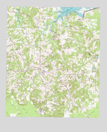
Harleton, TX USGS Topographic Map
Click on map above to begin viewing in our Map Viewer.

This topographic map contains these locations and features:
Feature Name Type Latitude Longitude GNIS ID View Map
Athey ChurchChurchN32.6510°W94.5394°1329818View Map
Bear Springs ChurchChurchN32.6454°W94.5094°1330251View Map
Brushy CreekStreamN32.7429°W94.5469°1331422View Map
Brushy Creek CampgroundLocaleN32.7429°W94.5360°1331440View Map
Center CemeteryCemeteryN32.6629°W94.5733°1332521View Map
Eagle Creek CemeteryCemeteryN32.6779°W94.6210°1334842View Map
Ferrells Bridge DamDamN32.7483°W94.5109°1335755View Map
HarletonPopulated PlaceN32.6765°W94.5746°1337353View Map
Harleton DivisionCivilN32.6626°W94.5209°1938824View Map
Harleton Post OfficePost OfficeN32.6751°W94.5724°2732169View Map
Harleton Volunteer Fire DepartmentBuildingN32.6751°W94.5712°2655534View Map
Hope Springs CemeteryCemeteryN32.6926°W94.5058°1338052View Map
Hope Springs LakeReservoirN32.6939°W94.5047°1338053View Map
JacksonPopulated PlaceN32.7363°W94.5813°1378488View Map
Jackson Community BuildingLocaleN32.7493°W94.5774°1338580View Map
Lake DeerwoodReservoirN32.7157°W94.5599°1861312View Map
Lake Deerwood Estates DamDamN32.7135°W94.5602°1861311View Map
Lakeside ParkParkN32.7493°W94.5199°2028996View Map
Liberty CemeteryCemeteryN32.7132°W94.5538°1339872View Map
Lodwick ChurchChurchN32.7371°W94.5758°1340322View Map
MacedoniaPopulated PlaceN32.7293°W94.5274°1378630View Map
Macedonia CemeteryCemeteryN32.7338°W94.5285°1340798View Map
Moccasin CreekStreamN32.6329°W94.5958°1341781View Map
Oak Grove ChurchChurchN32.6763°W94.5280°1342973View Map
Piney CemeteryCemeteryN32.6779°W94.5216°1344089View Map
Piney ChurchChurchN32.6757°W94.5210°1344090View Map
Pope CreekStreamN32.6349°W94.5885°1344360View Map
Smyrna ChurchChurchN32.7010°W94.6110°1347313View Map
West Abutment Recreational AreaParkN32.7354°W94.5246°1349671View Map
Whelan Gas FieldOilfieldN32.6876°W94.5980°1349911View Map

Note: Coordinates in the location and feature list above are referenced to NAD83 datum.


Copyright (C) 2008-2025 Ryan Niemi / Sunset Dynamics ... All Rights Reserved