TopoQuest Logo
Do you find TopoQuest useful?
Help keep TopoQuest running and adding new maps/features by donating!
Bitcoin:  19c7KJd3qBynnjoSw5npx9KScwjBe4ifkT
Litecoin:  LXs6TkuXGGXo1vDsWCkWVdjQX94eUKd6ui
Home View Maps Find Maps Find Places Resources & Links


Lost Creek Dam, Utah Topographic Map

USGS Map Title: Lost Creek Dam, UT
USGS Map MRC: 41111B4
DRG (GeoTIFF) Download: o41111b4.tif


Neighboring USGS Topographic Map Quads:


  Causey Dam, UT  
41111C5
 

  Horse Ridge, UT  
41111C4
 

  Peck Canyon, UT  
41111C3
 

  Bybee Knoll, UT  
41111B5
 

  Lost Creek Dam, UT  
41111B4
 

  Francis Canyon, UT  
41111B3
 

  Devils Slide, UT  
41111A5
 

  Henefer, UT  
41111A4
 

  Heiners Creek, UT  
41111A3


Map MRC Location:

N42°
W112°
N42°
W111°
H8 H7 H6 H5 H4 H3 H2 H1
G8 G7 G6 G5 G4 G3 G2 G1
F8 F7 F6 F5 F4 F3 F2 F1
E8 E7 E6 E5 E4 E3 E2 E1
D8 D7 D6 D5 D4 D3 D2 D1
C8 C7 C6 C5 C4 C3 C2 C1
B8 B7 B6 B5 B4 B3 B2 B1
A8 A7 A6 A5 A4 A3 A2 A1
N41°
W112°
N41°
W111°

Lost Creek Dam, UT USGS 1:24K Topographic Map Preview:
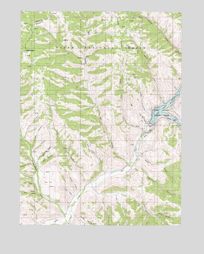
Lost Creek Dam, UT USGS Topographic Map
Click on map above to begin viewing in our Map Viewer.

This topographic map contains these locations and features:
Feature Name Type Latitude Longitude GNIS ID View Map
Belnap CreekStreamN41.1986°W111.3910°1438586View Map
Big FlatFlatN41.1499°W111.4788°1438667View Map
Buck CanyonValleyN41.1583°W111.4858°1439216View Map
Corral CanyonValleyN41.1749°W111.4966°1439962View Map
Coyote CanyonValleyN41.1311°W111.4588°1440109View Map
Deep CanyonValleyN41.1672°W111.4919°1440339View Map
Dirty HollowValleyN41.1494°W111.4894°1440475View Map
Francis CanyonValleyN41.1908°W111.3913°1441206View Map
Grassy CanyonValleyN41.1516°W111.4891°1441436View Map
Guilder PeakSummitN41.2269°W111.4968°1441521View Map
Guildersleeve CanyonValleyN41.1316°W111.4655°1441522View Map
Hell CanyonValleyN41.1605°W111.4166°1441672View Map
Little Deer HollowValleyN41.1855°W111.3996°1442698View Map
Little Trail CreekStreamN41.1797°W111.4038°1442787View Map
Lost Creek DamDamN41.1838°W111.3977°1442971View Map
Lost Creek ReservoirReservoirN41.1937°W111.3872°1442972View Map
Lost Creek State ParkParkN41.1858°W111.3819°1455378View Map
Mine HollowValleyN41.1316°W111.3980°1443505View Map
Paradise CanyonValleyN41.1597°W111.4135°1444183View Map
Red Cedar CanyonValleyN41.1549°W111.4355°1444783View Map
Road HollowValleyN41.1605°W111.4874°1445006View Map
Robinson MineMineN41.1319°W111.3880°1445025View Map
Rocky CanyonValleyN41.1494°W111.4477°1445111View Map
Soldier CanyonValleyN41.1444°W111.4560°1445765View Map
Spring CanyonValleyN41.1441°W111.4866°1445987View Map
Spring HollowValleyN41.1894°W111.3996°1446043View Map
Stokes CanyonValleyN41.1674°W111.4096°1446160View Map
Toone CanyonValleyN41.1466°W111.4455°1446653View Map
Turner CanyonValleyN41.1413°W111.4596°1446763View Map
Wasatch-Cache National ForestForestN41.2497°W111.4271°1454939View Map
Wheatgrass CanyonValleyN41.1622°W111.4913°1447207View Map
Wide CanyonValleyN41.1699°W111.4919°1447306View Map

Note: Coordinates in the location and feature list above are referenced to NAD83 datum.


Copyright (C) 2008-2025 Ryan Niemi / Sunset Dynamics ... All Rights Reserved