TopoQuest Logo
Do you find TopoQuest useful?
Help keep TopoQuest running and adding new maps/features by donating!
Bitcoin:  19c7KJd3qBynnjoSw5npx9KScwjBe4ifkT
Litecoin:  LXs6TkuXGGXo1vDsWCkWVdjQX94eUKd6ui
Home View Maps Find Maps Find Places Resources & Links


Loudonville, Ohio Topographic Map

USGS Map Title: Loudonville, OH
USGS Map MRC: 40082F2
DRG (GeoTIFF) Download: o40082f2.tif


Neighboring USGS Topographic Map Quads:


  Ashland South, OH  
40082G3
 

  Jeromesville, OH  
40082G2
 

  New Pittsburg, OH  
40082G1
 

  Perrysville, OH  
40082F3
 

  Loudonville, OH  
40082F2
 

  Shreve, OH  
40082F1
 

  Jelloway, OH  
40082E3
 

  Greer, OH  
40082E2
 

  Glenmont, OH  
40082E1


Map MRC Location:

N41°
W83°
N41°
W82°
H8 H7 H6 H5 H4 H3 H2 H1
G8 G7 G6 G5 G4 G3 G2 G1
F8 F7 F6 F5 F4 F3 F2 F1
E8 E7 E6 E5 E4 E3 E2 E1
D8 D7 D6 D5 D4 D3 D2 D1
C8 C7 C6 C5 C4 C3 C2 C1
B8 B7 B6 B5 B4 B3 B2 B1
A8 A7 A6 A5 A4 A3 A2 A1
N40°
W83°
N40°
W82°

Loudonville, OH USGS 1:24K Topographic Map Preview:
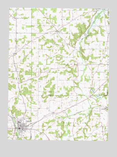
Loudonville, OH USGS Topographic Map
Click on map above to begin viewing in our Map Viewer.

This topographic map contains these locations and features:
Feature Name Type Latitude Longitude GNIS ID View Map
Bald KnobSummitN40.6545°W82.2390°1062578View Map
Big Run School (historical)SchoolN40.6676°W82.2340°1051112View Map
Blue Ridge School (historical)SchoolN40.6337°W82.1571°1056039View Map
Bonnett LakeLakeN40.6667°W82.1370°1038193View Map
Budd Elementary SchoolSchoolN40.6351°W82.2313°1051115View Map
County Line CemeteryCemeteryN40.7180°W82.2216°1039406View Map
Crab RunStreamN40.6559°W82.1454°1039431View Map
Emrick School (historical)SchoolN40.7106°W82.1696°1051120View Map
Kettering Hospital HeliportAirportN40.6445°W82.2288°1082804View Map
Lake ForkPopulated PlaceN40.7492°W82.1415°1064962View Map
Lakefork Post Office (historical)Post OfficeN40.7487°W82.1415°1958987View Map
LakevillePopulated PlaceN40.6562°W82.1271°1064965View Map
Lakeville Elementary SchoolSchoolN40.6570°W82.1265°1056059View Map
Lakeville Post OfficePost OfficeN40.6556°W82.1277°2013555View Map
LoudonvillePopulated PlaceN40.6353°W82.2332°1061446View Map
Loudonville CemeteryCemeteryN40.6309°W82.2324°1806350View Map
Loudonville Church of the NazareneChurchN40.6434°W82.2332°1051129View Map
Loudonville Fire DepartmentBuildingN40.6370°W82.2330°2550577View Map
Loudonville High SchoolSchoolN40.6387°W82.2429°1051130View Map
Loudonville Police DepartmentBuildingN40.6366°W82.2347°2732542View Map
Loudonville Post OfficePost OfficeN40.6362°W82.2332°1958904View Map
McKayPopulated PlaceN40.7059°W82.2429°1061494View Map
McKay CemeteryCemeteryN40.7042°W82.2457°1806353View Map
McKay Post Office (historical)Post OfficeN40.7056°W82.2429°1958925View Map
McMullen Elementary SchoolSchoolN40.6339°W82.2302°1051132View Map
McZenaPopulated PlaceN40.6973°W82.1374°1065729View Map
McZena Post Office (historical)Post OfficeN40.6973°W82.1374°1958926View Map
MohicanvillePopulated PlaceN40.7281°W82.1913°1065043View Map
Mohicanville CemeteryCemeteryN40.7267°W82.1838°1806356View Map
Mohicanville DamDamN40.7244°W82.1520°1043430View Map
Mohicanville ReservoirReservoirN40.7242°W82.1518°1077643View Map
Nesta AirportAirportN40.6377°W82.1787°1082803View Map
Old Sixteen CemeteryCemeteryN40.6951°W82.1646°1806362View Map
Pioneer CemeteryCemeteryN40.6966°W82.1524°1044488View Map
Plum RunStreamN40.6464°W82.1738°1044646View Map
Plum Run CemeteryCemeteryN40.6548°W82.2015°1044649View Map
Ridge School (historical)SchoolN40.7326°W82.1835°1051148View Map
Round LakeLakeN40.6721°W82.1446°1045222View Map
Saint Peters Catholic ChurchChurchN40.6364°W82.2307°1051153View Map
Saint Peters CemeteryCemeteryN40.6451°W82.2282°1045787View Map
Synagogue CemeteryCemeteryN40.7475°W82.2404°1806372View Map
Tea Hills Organic FarmLocaleN40.7022°W82.1769°2570572View Map
Township of LakeCivilN40.6971°W82.1739°1085707View Map
Township of WashingtonCivilN40.6317°W82.1635°1086340View Map
Village of LoudonvilleCivilN40.6342°W82.2328°2399190View Map

Note: Coordinates in the location and feature list above are referenced to NAD83 datum.


Copyright (C) 2008-2025 Ryan Niemi / Sunset Dynamics ... All Rights Reserved