TopoQuest Logo
Do you find TopoQuest useful?
Help keep TopoQuest running and adding new maps/features by donating!
Bitcoin:  19c7KJd3qBynnjoSw5npx9KScwjBe4ifkT
Litecoin:  LXs6TkuXGGXo1vDsWCkWVdjQX94eUKd6ui
Home View Maps Find Maps Find Places Resources & Links


Lowell, Ohio Topographic Map

USGS Map Title: Lowell, OH
USGS Map MRC: 39081E5
DRG (GeoTIFF) Download: o39081e5.tif


Neighboring USGS Topographic Map Quads:


  Reinersville, OH  
39081F6
 

  Caldwell South, OH  
39081F5
 

  Macksburg, OH  
39081F4
 

  Beverly, OH  
39081E6
 

  Lowell, OH  
39081E5
 

  Lower Salem, OH  
39081E4
 

  Watertown, OH  
39081D6
 

  Fleming, OH  
39081D5
 

  Marietta, OH  
39081D4


Map MRC Location:

N40°
W82°
N40°
W81°
H8 H7 H6 H5 H4 H3 H2 H1
G8 G7 G6 G5 G4 G3 G2 G1
F8 F7 F6 F5 F4 F3 F2 F1
E8 E7 E6 E5 E4 E3 E2 E1
D8 D7 D6 D5 D4 D3 D2 D1
C8 C7 C6 C5 C4 C3 C2 C1
B8 B7 B6 B5 B4 B3 B2 B1
A8 A7 A6 A5 A4 A3 A2 A1
N39°
W82°
N39°
W81°

Lowell, OH USGS 1:24K Topographic Map Preview:
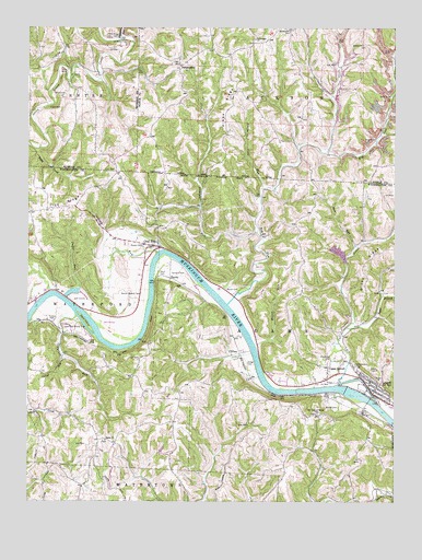
Lowell, OH USGS Topographic Map
Click on map above to begin viewing in our Map Viewer.

This topographic map contains these locations and features:
Feature Name Type Latitude Longitude GNIS ID View Map
Bear RunStreamN39.5676°W81.5126°1037726View Map
Big RunStreamN39.5523°W81.5557°1038025View Map
Big Run School (historical)SchoolN39.5995°W81.5210°1050996View Map
Boyd CemeteryCemeteryN39.6076°W81.6123°1038239View Map
Cat CreekStreamN39.5317°W81.5179°1066633View Map
Checkpoint Charlie Airport (historical)AirportN39.5562°W81.5678°1082811View Map
Clark CemeteryCemeteryN39.6040°W81.6138°1071006View Map
CliftonPopulated PlaceN39.5395°W81.5518°1062699View Map
Coal RunPopulated PlaceN39.5676°W81.5812°1060980View Map
Congress RunStreamN39.5490°W81.6085°1039307View Map
Culver RunStreamN39.5379°W81.6129°1039530View Map
Cushing RunStreamN39.5662°W81.5798°1070728View Map
Dana IslandIslandN39.5476°W81.6054°1039569View Map
Devol CemeteryCemeteryN39.5600°W81.5814°1039689View Map
Dodge CemeteryCemeteryN39.5365°W81.5496°1039728View Map
DungannonPopulated PlaceN39.6151°W81.5723°1064566View Map
East Salem School (historical)SchoolN39.5192°W81.5754°1050680View Map
EquityPopulated PlaceN39.5590°W81.5757°1062753View Map
Fair Play School (historical)SchoolN39.5515°W81.5593°1050682View Map
Federal BottomFlatN39.5501°W81.6157°1963900View Map
Glendale School (historical)SchoolN39.5076°W81.6187°1050676View Map
Greenlawn CemeteryCemeteryN39.5381°W81.5196°1041134View Map
Greenwood School (historical)SchoolN39.5176°W81.5496°1050681View Map
Haines CemeteryCemeteryN39.6203°W81.5110°1963678View Map
Haines ChurchChurchN39.6206°W81.5107°1041237View Map
Harr CemeteryCemeteryN39.5873°W81.5953°1041351View Map
Hibbs RidgeRidgeN39.6034°W81.5560°1041516View Map
Hog Hollow School (historical)SchoolN39.5956°W81.5601°1050994View Map
Lakeside Golf CourseLocaleN39.5534°W81.6073°1050679View Map
Lakeside Motel PondReservoirN39.5553°W81.6097°1077759View Map
Lakeside Motel Pond DamDamN39.5551°W81.6132°1077758View Map
Lakeside Resort Colony Airport (historical)AirportN39.5515°W81.6062°1082500View Map
Lewis CemeteryCemeteryN39.5351°W81.5078°1963913View Map
Little Cold RunStreamN39.5829°W81.5440°1042652View Map
LowellPopulated PlaceN39.5298°W81.5062°1065718View Map
Lowell - Adams Volunteer Fire Rescue DepartmentBuildingN39.5274°W81.5061°2549805View Map
Lowell Elementary SchoolSchoolN39.5315°W81.5082°1050683View Map
Lowell Station (historical)LocaleN39.5237°W81.5104°1067267View Map
Lowell Trailer ParkPopulated PlaceN39.5272°W81.5033°2576351View Map
Marsh CemeteryCemeteryN39.5561°W81.5571°1043010View Map
Mason CemeteryCemeteryN39.5250°W81.5185°1043044View Map
Mason CemeteryCemeteryN39.5676°W81.5851°1043045View Map
Mason RunStreamN39.5415°W81.5465°1043048View Map
Muskingum River Lock and Dam NumberReservoirN39.5301°W81.5165°1078825View Map
Muskingum River Lock and Dam Number ThreeDamN39.5295°W81.5165°1078824View Map
Newtonville School (historical)SchoolN39.5981°W81.6018°1051212View Map
Old German CemeteryCemeteryN39.5365°W81.5125°1044104View Map
Our Lady of Mercy CemeteryCemeteryN39.5231°W81.5265°1963928View Map
Our Lady of Mercy ChurchChurchN39.5234°W81.5254°1065224View Map
Powers CemeteryCemeteryN39.5476°W81.6165°1044737View Map
Reasoners RunStreamN39.6220°W81.5926°1044888View Map
Right Branch Cat CreekStreamN39.5459°W81.5154°1045019View Map
Round Bottom CemeteryCemeteryN39.5545°W81.5860°1045219View Map
Round Bottom Church (historical)ChurchN39.5551°W81.5865°1050678View Map
Salem Church CemeteryCemeteryN39.5162°W81.5990°1963935View Map
Sprague CemeteryCemeteryN39.5598°W81.5721°1046540View Map
Stong CreekStreamN39.5929°W81.6221°1046723View Map
Stony CreekStreamN39.5931°W81.6224°1065802View Map
Strahler PondReservoirN39.5137°W81.5791°1077757View Map
Strahler Pond DamDamN39.5134°W81.5798°1077756View Map
Straight RunStreamN39.5715°W81.5457°1046758View Map
Straight Run School (historical)SchoolN39.5712°W81.5565°1077546View Map
Sugar RunStreamN39.5565°W81.6071°1046824View Map
Tick RidgeRidgeN39.5762°W81.6243°1060547View Map
Townhouse SchoolSchoolN39.6240°W81.5351°1047109View Map
Township of AdamsCivilN39.5454°W81.5271°1087124View Map
Township of JacksonCivilN39.6235°W81.5303°1086745View Map
Upper LowellPopulated PlaceN39.5356°W81.5218°1047369View Map
Village of LowellCivilN39.5293°W81.5068°2399194View Map
Wall Street School (historical)SchoolN39.5337°W81.5896°1050677View Map
Williamson ChurchChurchN39.6220°W81.5465°1047938View Map

Note: Coordinates in the location and feature list above are referenced to NAD83 datum.


Copyright (C) 2008-2024 Ryan Niemi / Sunset Dynamics ... All Rights Reserved