TopoQuest Logo
Do you find TopoQuest useful?
Help keep TopoQuest running and adding new maps/features by donating!
Bitcoin:  19c7KJd3qBynnjoSw5npx9KScwjBe4ifkT
Litecoin:  LXs6TkuXGGXo1vDsWCkWVdjQX94eUKd6ui
Home View Maps Find Maps Find Places Resources & Links


Watertown, Ohio Topographic Map

USGS Map Title: Watertown, OH
USGS Map MRC: 39081D6
DRG (GeoTIFF) Download: o39081d6.tif


Neighboring USGS Topographic Map Quads:


  Stockport, OH  
39081E7
 

  Beverly, OH  
39081E6
 

  Lowell, OH  
39081E5
 

  Chesterhill, OH  
39081D7
 

  Watertown, OH  
39081D6
 

  Fleming, OH  
39081D5
 

  Cutler, OH  
39081C7
 

  Little Hocking, OH  
39081C6
 

  Parkersburg, WV  
39081C5


Map MRC Location:

N40°
W82°
N40°
W81°
H8 H7 H6 H5 H4 H3 H2 H1
G8 G7 G6 G5 G4 G3 G2 G1
F8 F7 F6 F5 F4 F3 F2 F1
E8 E7 E6 E5 E4 E3 E2 E1
D8 D7 D6 D5 D4 D3 D2 D1
C8 C7 C6 C5 C4 C3 C2 C1
B8 B7 B6 B5 B4 B3 B2 B1
A8 A7 A6 A5 A4 A3 A2 A1
N39°
W82°
N39°
W81°

Watertown, OH USGS 1:24K Topographic Map Preview:
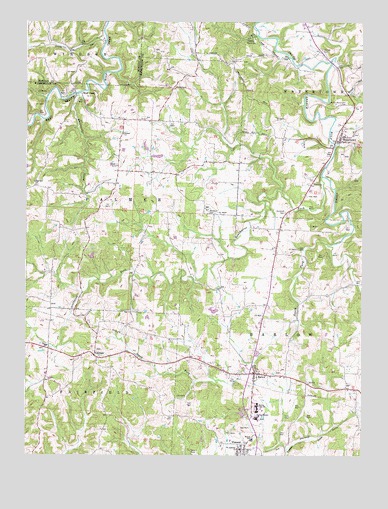
Watertown, OH USGS Topographic Map
Click on map above to begin viewing in our Map Viewer.

This topographic map contains these locations and features:
Feature Name Type Latitude Longitude GNIS ID View Map
BarlowPopulated PlaceN39.3987°W81.6649°1064380View Map
Barlow Central CemeteryCemeteryN39.3987°W81.6554°1963876View Map
Barlow Methodist ChurchChurchN39.3976°W81.6549°1963877View Map
Barlow Volunteer Fire DepartmentBuildingN39.3933°W81.6657°2549807View Map
Barlow-Vincent Elementary SchoolSchoolN39.3856°W81.6640°1081034View Map
Bell BridgeBridgeN39.4312°W81.6760°1050695View Map
Browns MillLocaleN39.4612°W81.7157°1065540View Map
Camp HervidaLocaleN39.4956°W81.6674°1038703View Map
Cody CemeteryCemeteryN39.3937°W81.7495°1075604View Map
Harra BridgeBridgeN39.4879°W81.6479°1050696View Map
LaymanPopulated PlaceN39.4034°W81.7243°1062847View Map
Layman CemeteryCemeteryN39.4051°W81.7240°1963912View Map
Lucas RunStreamN39.4942°W81.7212°1076315View Map
Murdock CemeteryCemeteryN39.4448°W81.6826°1043738View Map
North Watertown CemeteryCemeteryN39.4763°W81.6310°1043976View Map
Painter RunStreamN39.4648°W81.6349°1044281View Map
Palmer United Methodist ChurchChurchN39.4676°W81.7143°1044288View Map
Plumb RunStreamN39.4876°W81.6362°1044651View Map
Saint Ambrose ChurchChurchN39.3767°W81.6710°1045365View Map
South Fork South Branch Wolf CreekStreamN39.4356°W81.6371°1046470View Map
Southwest Fork South Branch Wolf CreekStreamN39.4551°W81.6401°1046511View Map
Stanley CemeteryCemeteryN39.4923°W81.6401°1046631View Map
Sterling AcresLocaleN39.4181°W81.7200°2706148View Map
Township of BarlowCivilN39.3986°W81.6435°1087126View Map
Township of FairfieldCivilN39.3799°W81.7411°1087131View Map
Township of PalmerCivilN39.4525°W81.7207°1087142View Map
VincentPopulated PlaceN39.3754°W81.6696°1065440View Map
Vincent United Methodist ChurchChurchN39.3770°W81.6699°1060590View Map
Wagner PondReservoirN39.4324°W81.7255°1079283View Map
Wagner PondReservoirN39.4452°W81.7044°1077761View Map
Wagner Pond DamDamN39.4317°W81.7249°1079282View Map
Wagner Pond DamDamN39.4451°W81.7049°1077760View Map
Warren Elementary SchoolSchoolN39.3795°W81.6657°1081988View Map
Warren High SchoolSchoolN39.3887°W81.6640°1047577View Map
WatertownPopulated PlaceN39.4659°W81.6332°1049298View Map
Watertown Elementary SchoolSchoolN39.4687°W81.6285°1050697View Map
Watertown Historic DistrictParkN39.4673°W81.6332°1071668View Map
Watertown Volunteer Fire DepartmentBuildingN39.4664°W81.6336°2549554View Map
Whitewater CreekStreamN39.4792°W81.7310°1047884View Map
Wolf CreekPopulated PlaceN39.4795°W81.7321°1063099View Map
Woodruff CemeteryCemeteryN39.4451°W81.6535°1048100View Map

Note: Coordinates in the location and feature list above are referenced to NAD83 datum.


Copyright (C) 2008-2025 Ryan Niemi / Sunset Dynamics ... All Rights Reserved