TopoQuest Logo
Do you find TopoQuest useful?
Help keep TopoQuest running and adding new maps/features by donating!
Bitcoin:  19c7KJd3qBynnjoSw5npx9KScwjBe4ifkT
Litecoin:  LXs6TkuXGGXo1vDsWCkWVdjQX94eUKd6ui
Home View Maps Find Maps Find Places Resources & Links


Lowell, Indiana Topographic Map

USGS Map Title: Lowell, IN
USGS Map MRC: 41087C4
DRG (GeoTIFF) Download: o41087c4.tif


Neighboring USGS Topographic Map Quads:


  Dyer, IN  
41087D5
 

  Saint John, IN  
41087D4
 

  Crown Point, IN  
41087D3
 

  Beecher East, IL  
41087C5
 

  Lowell, IN  
41087C4
 

  Leroy, IN  
41087C3
 

  Illiana Heights, IL  
41087B5
 

  Schneider, IN  
41087B4
 

  Shelby, IN  
41087B3


Map MRC Location:

N42°
W88°
N42°
W87°
H8 H7 H6 H5 H4 H3 H2 H1
G8 G7 G6 G5 G4 G3 G2 G1
F8 F7 F6 F5 F4 F3 F2 F1
E8 E7 E6 E5 E4 E3 E2 E1
D8 D7 D6 D5 D4 D3 D2 D1
C8 C7 C6 C5 C4 C3 C2 C1
B8 B7 B6 B5 B4 B3 B2 B1
A8 A7 A6 A5 A4 A3 A2 A1
N41°
W88°
N41°
W87°

Lowell, IN USGS 1:24K Topographic Map Preview:
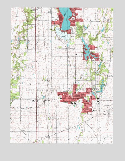
Lowell, IN USGS Topographic Map
Click on map above to begin viewing in our Map Viewer.

This topographic map contains these locations and features:
Feature Name Type Latitude Longitude GNIS ID View Map
Apostolic Fellowship ChurchChurchN41.3623°W87.4161°2040880View Map
BelshawPopulated PlaceN41.2564°W87.4534°430788View Map
Bethany ChapelChurchN41.2978°W87.4303°450208View Map
Bruce DitchCanalN41.2603°W87.4484°431651View Map
Buckley Homestead County ParkParkN41.2842°W87.3764°450213View Map
Cedar LakeLakeN41.3704°W87.4324°432279View Map
Cedar LakePopulated PlaceN41.3648°W87.4411°432282View Map
Cedar Lake Police DepartmentBuildingN41.3679°W87.4247°2758110View Map
Cedar Lake United Methodist ChurchChurchN41.3695°W87.4211°2040881View Map
Community Bible ChurchChurchN41.3723°W87.4709°452915View Map
CrestonPopulated PlaceN41.3378°W87.4314°433117View Map
Creston CemeteryCemeteryN41.3385°W87.4305°450211View Map
Dalecarlia Bible ChurchChurchN41.3267°W87.4011°2040873View Map
Evergreen ParkParkN41.2889°W87.4056°434267View Map
First Baptist ChurchChurchN41.3742°W87.4500°2040882View Map
First Baptist Church of LowellChurchN41.2967°W87.4223°2040874View Map
First Church of the NazareneChurchN41.2881°W87.3920°2040875View Map
First United Methodist ChurchChurchN41.2914°W87.4184°2040876View Map
Foss DitchCanalN41.3639°W87.3875°434695View Map
German Methodist Episcopal CemeteryCemeteryN41.3488°W87.4687°435041View Map
Hope Lutheran ChurchChurchN41.3631°W87.4436°436440View Map
Lake Bel-AireLakeN41.2949°W87.3982°450206View Map
Lake DalecarliaPopulated PlaceN41.3309°W87.3948°433293View Map
Lake DalecarliaReservoirN41.3267°W87.4048°433294View Map
Lake Dalecarlia Census Designated PlaceCensusN41.3370°W87.4037°2393077View Map
Lake Dalecarlia Dam EastDamN41.3267°W87.4045°448695View Map
Lake Dalecarlia Dam WestDamN41.3267°W87.4050°448696View Map
Lake Dalecarlia Volunteer Fire DepartmentBuildingN41.3269°W87.4012°2625656View Map
Lake Prairie CemeteryCemeteryN41.2893°W87.4689°452945View Map
Lake Prairie ChurchChurchN41.2825°W87.4873°437536View Map
Lake Prairie Elementary SchoolSchoolN41.2895°W87.4723°437537View Map
Lakeside Baptist ChurchChurchN41.3650°W87.4370°2040883View Map
Liberty ParkParkN41.2931°W87.4248°450209View Map
LowellPopulated PlaceN41.2914°W87.4206°438358View Map
Lowell Baptist SchoolSchoolN41.2967°W87.4220°2040012View Map
Lowell Commercial Historic DistrictParkN41.2917°W87.4206°2041367View Map
Lowell Fire DepartmentBuildingN41.2908°W87.4086°2625742View Map
Lowell Memorial CemeteryCemeteryN41.2914°W87.4075°450205View Map
Lowell Middle SchoolSchoolN41.2981°W87.4184°447438View Map
Lowell Police DepartmentBuildingN41.2908°W87.4082°2758455View Map
Lowell Post OfficePost OfficeN41.2920°W87.4264°2040810View Map
Lowell Public LibraryBuildingN41.2939°W87.4192°2040806View Map
Lowell Senior High SchoolSchoolN41.2875°W87.4264°447439View Map
Lowell Southern Baptist ChurchChurchN41.2925°W87.4203°2040877View Map
Maple Grove Greenhouse and NurseryBuildingN41.3208°W87.3792°2634518View Map
McConnel DitchCanalN41.3095°W87.4153°438808View Map
North HaydenPopulated PlaceN41.2900°W87.4584°440264View Map
Oak Hill Elementary SchoolSchoolN41.2867°W87.4245°440440View Map
Oakland School (historical)SchoolN41.2536°W87.4600°450309View Map
Onehundredthirtyseventh Avenue ParkParkN41.3686°W87.4231°2040903View Map
Pheasant Valley Country ClubLocaleN41.3667°W87.3834°450210View Map
Redwing LakeLakeN41.3003°W87.3898°441841View Map
Reservation ParkParkN41.2953°W87.4350°450207View Map
Saint Edwards CemeteryCemeteryN41.2967°W87.4028°442526View Map
Saint Edwards ChurchChurchN41.2878°W87.4306°2040878View Map
Saint Edwards SchoolSchoolN41.2878°W87.4314°442528View Map
South Lake County Community ServicesBuildingN41.3695°W87.4186°450212View Map
South Shore Country ClubLocaleN41.3514°W87.4273°452397View Map
Sutton's FieldAirportN41.3201°W87.4772°2676876View Map
Three Creeks Elementary SchoolSchoolN41.2803°W87.3986°450204View Map
Town of Cedar LakeCivilN41.3694°W87.4380°2396634View Map
Town of LowellCivilN41.2934°W87.4184°2396726View Map
Township of Cedar CreekCivilN41.2596°W87.3831°453171View Map
Township of West CreekCivilN41.2588°W87.4785°454048View Map
Tri - Creek Emergency Medical ServicesBuildingN41.2908°W87.4084°2719324View Map
Trinity Lutheran ChurchChurchN41.2898°W87.4350°2040879View Map
Wietbrock AirportAirportN41.2600°W87.4797°450327View Map
Wietbrock AirportAirportN41.2600°W87.4797°2677111View Map

Note: Coordinates in the location and feature list above are referenced to NAD83 datum.


Copyright (C) 2008-2024 Ryan Niemi / Sunset Dynamics ... All Rights Reserved