TopoQuest Logo
Do you find TopoQuest useful?
Help keep TopoQuest running and adding new maps/features by donating!
Bitcoin:  19c7KJd3qBynnjoSw5npx9KScwjBe4ifkT
Litecoin:  LXs6TkuXGGXo1vDsWCkWVdjQX94eUKd6ui
Home View Maps Find Maps Find Places Resources & Links


Schneider, Indiana Topographic Map

USGS Map Title: Schneider, IN
USGS Map MRC: 41087B4
DRG (GeoTIFF) Download: o41087b4.tif


Neighboring USGS Topographic Map Quads:


  Beecher East, IL  
41087C5
 

  Lowell, IN  
41087C4
 

  Leroy, IN  
41087C3
 

  Illiana Heights, IL  
41087B5
 

  Schneider, IN  
41087B4
 

  Shelby, IN  
41087B3
 

  Leesville, IL  
41087A5
 

  Enos, IN  
41087A4
 

  Fair Oaks, IN  
41087A3


Map MRC Location:

N42°
W88°
N42°
W87°
H8 H7 H6 H5 H4 H3 H2 H1
G8 G7 G6 G5 G4 G3 G2 G1
F8 F7 F6 F5 F4 F3 F2 F1
E8 E7 E6 E5 E4 E3 E2 E1
D8 D7 D6 D5 D4 D3 D2 D1
C8 C7 C6 C5 C4 C3 C2 C1
B8 B7 B6 B5 B4 B3 B2 B1
A8 A7 A6 A5 A4 A3 A2 A1
N41°
W88°
N41°
W87°

Schneider, IN USGS 1:24K Topographic Map Preview:
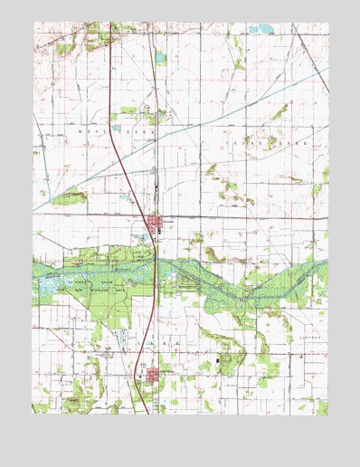
Schneider, IN USGS Topographic Map
Click on map above to begin viewing in our Map Viewer.

This topographic map contains these locations and features:
Feature Name Type Latitude Longitude GNIS ID View Map
Bailey DitchCanalN41.2314°W87.4820°430408View Map
Best DitchCanalN41.1264°W87.4995°430856View Map
Calvary Baptist ChurchChurchN41.1775°W87.4500°450017View Map
Cedar CreekStreamN41.2198°W87.4206°432268View Map
Fuller DitchCanalN41.1878°W87.4000°434893View Map
House of God ChurchChurchN41.1442°W87.4292°450018View Map
Lake Township Volunteer Fire DepartmentBuildingN41.1409°W87.4494°2626223View Map
Lake VillagePopulated PlaceN41.1375°W87.4486°437545View Map
Lake Village AirportAirportN41.1453°W87.4612°449242View Map
Lake Village CemeteryCemeteryN41.1440°W87.4688°437544View Map
Lake Village Census Designated PlaceCensusN41.1308°W87.4390°2393086View Map
Lake Village Elementary SchoolSchoolN41.1373°W87.4536°447323View Map
Lowell QuarryMineN41.2414°W87.4472°2566581View Map
Oakwood Mobile Home ParkPopulated PlaceN41.2486°W87.4661°2514864View Map
Saint Augusta ChurchChurchN41.1453°W87.4528°442489View Map
Sanders CemeteryCemeteryN41.2466°W87.4577°442996View Map
SchneiderPopulated PlaceN41.1870°W87.4484°443082View Map
Schneider Community HallBuildingN41.1814°W87.4484°450016View Map
Schneider Police DepartmentBuildingN41.1857°W87.4484°2758484View Map
Sumava ResortsPopulated PlaceN41.1664°W87.4392°444386View Map
Sumava Resorts Post Office (historical)Post OfficeN41.1664°W87.4392°2027053View Map
Town of SchneiderCivilN41.1929°W87.4462°2396908View Map
Township of LakeCivilN41.1275°W87.4593°453537View Map
Village Baptist ChurchChurchN41.1420°W87.4684°451857View Map
West CreekStreamN41.1928°W87.4939°445732View Map
West Creek Township Fire DepartmentBuildingN41.1857°W87.4487°2625517View Map
Williams DitchCanalN41.1742°W87.4328°452919View Map

Note: Coordinates in the location and feature list above are referenced to NAD83 datum.


Copyright (C) 2008-2025 Ryan Niemi / Sunset Dynamics ... All Rights Reserved