TopoQuest Logo
Do you find TopoQuest useful?
Help keep TopoQuest running and adding new maps/features by donating!
Bitcoin:  19c7KJd3qBynnjoSw5npx9KScwjBe4ifkT
Litecoin:  LXs6TkuXGGXo1vDsWCkWVdjQX94eUKd6ui
Home View Maps Find Maps Find Places Resources & Links


Grantville, Georgia Topographic Map

USGS Map Title: Grantville, GA
USGS Map MRC: 33084B7
DRG (GeoTIFF) Download: o33084b7.tif


Neighboring USGS Topographic Map Quads:


  Newnan SW, GA  
33084C8
 

  Newnan South, GA  
33084C7
 

  Sharpsburg, GA  
33084C6
 

  Hogansville, GA  
33084B8
 

  Grantville, GA  
33084B7
 

  Luthersville, GA  
33084B6
 

  Mountville, GA  
33084A8
 

  Odessadale, GA  
33084A7
 

  Greenville, GA  
33084A6


Map MRC Location:

N34°
W85°
N34°
W84°
H8 H7 H6 H5 H4 H3 H2 H1
G8 G7 G6 G5 G4 G3 G2 G1
F8 F7 F6 F5 F4 F3 F2 F1
E8 E7 E6 E5 E4 E3 E2 E1
D8 D7 D6 D5 D4 D3 D2 D1
C8 C7 C6 C5 C4 C3 C2 C1
B8 B7 B6 B5 B4 B3 B2 B1
A8 A7 A6 A5 A4 A3 A2 A1
N33°
W85°
N33°
W84°

Grantville, GA USGS 1:24K Topographic Map Preview:
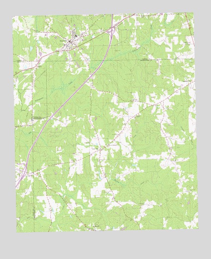
Grantville, GA USGS Topographic Map
Click on map above to begin viewing in our Map Viewer.

This topographic map contains these locations and features:
Feature Name Type Latitude Longitude GNIS ID View Map
Allen-Lee Memorial ChurchChurchN33.1746°W84.8110°354284View Map
Bradberry CemeteryCemeteryN33.2259°W84.7819°311699View Map
Braswell CemeteryCemeteryN33.2040°W84.7638°354841View Map
Brewer LakeReservoirN33.2313°W84.8623°339862View Map
Brewer Lake DamDamN33.2318°W84.8616°339861View Map
Burdette BridgeBridgeN33.1579°W84.8099°346841View Map
Campground CemeteryCemeteryN33.1404°W84.7869°312271View Map
City of GrantvilleCivilN33.2371°W84.8293°2403727View Map
Colley LakeReservoirN33.2495°W84.7852°312841View Map
Coweta County Fire Department Station 11BuildingN33.2392°W84.8438°2604388View Map
Crowley CemeteryCemeteryN33.1971°W84.7783°313189View Map
East Trammel BranchStreamN33.2332°W84.7708°348473View Map
Emmaus Progressive Baptist ChurchChurchN33.1576°W84.8663°355689View Map
Exit 6CrossingN33.1598°W84.8685°1673073View Map
Glanton Elementary SchoolSchoolN33.2339°W84.8275°2546276View Map
GrantvillePopulated PlaceN33.2348°W84.8358°356079View Map
Grantville Brown SchoolSchoolN33.2329°W84.8391°348497View Map
Grantville City CemeteryCemeteryN33.2362°W84.8288°348498View Map
Grantville High SchoolSchoolN33.2354°W84.8269°348499View Map
Grantville Historic DistrictParkN33.2343°W84.8347°348500View Map
Grantville Police DepartmentBuildingN33.2330°W84.8392°2733721View Map
Hilly LakeReservoirN33.2280°W84.8562°339854View Map
Hilly Lake DamDamN33.2285°W84.8566°339853View Map
Holly Springs Baptist ChurchChurchN33.2315°W84.7547°315571View Map
Holly Springs CemeteryCemeteryN33.2315°W84.7547°348509View Map
John C Meadows CemeteryCemeteryN33.2401°W84.8094°317991View Map
Lambert CemeteryCemeteryN33.2237°W84.8244°316594View Map
Lone OakPopulated PlaceN33.1718°W84.8160°317301View Map
Luthersville DivisionCivilN33.1555°W84.7770°1936380View Map
M K FieldAirportN33.1684°W84.8296°2717130View Map
Macedonia ChurchChurchN33.1998°W84.7935°317551View Map
Meriwether County Volunteer Fire Department Station 3BuildingN33.1720°W84.8134°2603963View Map
Possum Trot CemeteryCemeteryN33.1471°W84.7558°321082View Map
Prospect CemeteryCemeteryN33.1748°W84.8113°346910View Map
Providence CemeteryCemeteryN33.1801°W84.8030°321181View Map
Providence Primitive Baptist Church (historical)ChurchN33.1807°W84.8033°346911View Map
Saint MarksPopulated PlaceN33.1254°W84.8210°322170View Map
Saint Pauls CemeteryCemeteryN33.1662°W84.8338°322240View Map
Saint Pauls ChurchChurchN33.1760°W84.8233°322274View Map
Samuel Meadows CemeteryCemeteryN33.2499°W84.8182°317992View Map
Stevens CemeteryCemeteryN33.2287°W84.8049°323590View Map
Town of Lone OakCivilN33.1724°W84.8173°2406039View Map
Turkey CreekStreamN33.1548°W84.8105°324370View Map
Union CemeteryCemeteryN33.1262°W84.8260°346925View Map
Union ChurchChurchN33.1260°W84.8255°324527View Map
West Trammel BranchStreamN33.2323°W84.7744°348634View Map
Whitehead LakeReservoirN33.1262°W84.8017°340323View Map
Whitehead Lake DamDamN33.1251°W84.8033°340322View Map
Zion Hill ChurchChurchN33.1651°W84.7658°325697View Map

Note: Coordinates in the location and feature list above are referenced to NAD83 datum.


Copyright (C) 2008-2024 Ryan Niemi / Sunset Dynamics ... All Rights Reserved