TopoQuest Logo
Do you find TopoQuest useful?
Help keep TopoQuest running and adding new maps/features by donating!
Bitcoin:  19c7KJd3qBynnjoSw5npx9KScwjBe4ifkT
Litecoin:  LXs6TkuXGGXo1vDsWCkWVdjQX94eUKd6ui
Home View Maps Find Maps Find Places Resources & Links


Mackay Ranch, Montana Topographic Map

USGS Map Title: Mackay Ranch, MT
USGS Map MRC: 45109C5
DRG (GeoTIFF) Download: o45109c5.tif


Neighboring USGS Topographic Map Quads:


  Beehive, MT  
45109D6
 

  Fishtail, MT  
45109D5
 

  Roscoe NW, MT  
45109D4
 

  Emerald Lake, MT  
45109C6
 

  Mackay Ranch, MT  
45109C5
 

  Roscoe, MT  
45109C4
 

  Alpine, MT  
45109B6
 

  Sylvan Peak, MT  
45109B5
 

  Bare Mountain, MT  
45109B4


Map MRC Location:

N46°
W110°
N46°
W109°
H8 H7 H6 H5 H4 H3 H2 H1
G8 G7 G6 G5 G4 G3 G2 G1
F8 F7 F6 F5 F4 F3 F2 F1
E8 E7 E6 E5 E4 E3 E2 E1
D8 D7 D6 D5 D4 D3 D2 D1
C8 C7 C6 C5 C4 C3 C2 C1
B8 B7 B6 B5 B4 B3 B2 B1
A8 A7 A6 A5 A4 A3 A2 A1
N45°
W110°
N45°
W109°

Mackay Ranch, MT USGS 1:24K Topographic Map Preview:
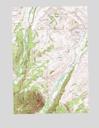
Mackay Ranch, MT USGS Topographic Map
Click on map above to begin viewing in our Map Viewer.

This topographic map contains these locations and features:
Feature Name Type Latitude Longitude GNIS ID View Map
05S17E27BCBA01 WellWellN45.3736°W109.6218°809168View Map
06S18E04AADA01 WellWellN45.3391°W109.5077°809005View Map
Antelope BasinBasinN45.3430°W109.5152°779057View Map
Antelope Basin DitchCanalN45.3399°W109.5260°779059View Map
Black ButteSummitN45.2672°W109.5902°779978View Map
Brown PlaceLocaleN45.3324°W109.5041°794842View Map
East Fork Fiddler CreekStreamN45.3741°W109.6066°782843View Map
George Place (historical)Populated PlaceN45.3591°W109.5168°783899View Map
John George DitchCanalN45.3416°W109.5154°785510View Map
Mackay RanchLocaleN45.3152°W109.5485°801116View Map
Mackay Ranch Airport (historical)AirportN45.3199°W109.5491°806513View Map
Middle Fork Fiddler CreekStreamN45.3730°W109.6093°787272View Map
Morris CreekStreamN45.3438°W109.5002°787702View Map
Oakley-Parker DitchCanalN45.3547°W109.5921°788374View Map
Peabody DitchCanalN45.3224°W109.5041°788719View Map
Reeves RanchLocaleN45.2880°W109.6238°789514View Map
Roscoe CemeteryCemeteryN45.3492°W109.5051°789771View Map
Stick-in-the Mud DamDamN45.3549°W109.5724°796563View Map
T O Bar RanchLocaleN45.2658°W109.5588°791841View Map
Top Hat RanchLocaleN45.3711°W109.5474°792280View Map

Note: Coordinates in the location and feature list above are referenced to NAD83 datum.


Copyright (C) 2008-2025 Ryan Niemi / Sunset Dynamics ... All Rights Reserved