TopoQuest Logo
Do you find TopoQuest useful?
Help keep TopoQuest running and adding new maps/features by donating!
Bitcoin:  19c7KJd3qBynnjoSw5npx9KScwjBe4ifkT
Litecoin:  LXs6TkuXGGXo1vDsWCkWVdjQX94eUKd6ui
Home View Maps Find Maps Find Places Resources & Links


Macon NE, Georgia Topographic Map

USGS Map Title: Macon NE, GA
USGS Map MRC: 32083H5
DRG (GeoTIFF) Download: o32083h5.tif


Neighboring USGS Topographic Map Quads:


  Dames Ferry, GA  
33083A6
 

  Gray, GA  
33083A5
 

  Haddock, GA  
33083A4
 

  Macon NW, GA  
32083H6
 

  Macon NE, GA  
32083H5
 

  James, GA  
32083H4
 

  Macon West, GA  
32083G6
 

  Macon East, GA  
32083G5
 

  Dry Branch, GA  
32083G4


Map MRC Location:

N33°
W84°
N33°
W83°
H8 H7 H6 H5 H4 H3 H2 H1
G8 G7 G6 G5 G4 G3 G2 G1
F8 F7 F6 F5 F4 F3 F2 F1
E8 E7 E6 E5 E4 E3 E2 E1
D8 D7 D6 D5 D4 D3 D2 D1
C8 C7 C6 C5 C4 C3 C2 C1
B8 B7 B6 B5 B4 B3 B2 B1
A8 A7 A6 A5 A4 A3 A2 A1
N32°
W84°
N32°
W83°

Macon NE, GA USGS 1:24K Topographic Map Preview:
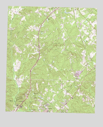
Macon NE, GA USGS Topographic Map
Click on map above to begin viewing in our Map Viewer.

This topographic map contains these locations and features:
Feature Name Type Latitude Longitude GNIS ID View Map
Anderson LakeReservoirN32.9849°W83.5693°310524View Map
Anderson Lake DamDamN32.9862°W83.5691°340507View Map
Bartlett BranchStreamN32.9451°W83.6182°310831View Map
Bateman LakeReservoirN32.9944°W83.5430°310851View Map
Bateman Lake DamDamN32.9946°W83.5457°340505View Map
Bonner CreekStreamN32.9557°W83.6149°327194View Map
Bowden HillsPopulated PlaceN32.8760°W83.5691°345334View Map
Brasswells LakeReservoirN32.9690°W83.5764°311735View Map
Brasswells Lake DamDamN32.9690°W83.5774°340511View Map
Bray BranchStreamN32.9935°W83.6116°327214View Map
Camp JoycliffLocaleN32.8924°W83.5843°354970View Map
Chapman CemeteryCemeteryN32.9090°W83.5491°312567View Map
Clifton Ridge Middle SchoolSchoolN32.8806°W83.5820°2545567View Map
ClintonPopulated PlaceN32.9987°W83.5554°355194View Map
CumsloPopulated PlaceN32.9474°W83.5166°331495View Map
Dames Ferry Elementary SchoolSchoolN32.9861°W83.6027°2545782View Map
Elam ChurchChurchN32.9732°W83.5099°355656View Map
Ethridge DamDamN32.9618°W83.5282°340515View Map
Ethridge LakeReservoirN32.9627°W83.5280°340516View Map
Feagin Hill CreekStreamN32.9524°W83.5641°314091View Map
Glawson CreekStreamN32.9812°W83.6191°327947View Map
Gray Elementary SchoolSchoolN32.9977°W83.5309°345353View Map
Gray Station Middle SchoolSchoolN32.9944°W83.5269°2545565View Map
Gray-Macon East DivisionCivilN32.9571°W83.5221°1936295View Map
Harris CemeteryCemeteryN32.9090°W83.5818°315183View Map
Henderson Stripling CemeteryCemeteryN32.8940°W83.5113°315325View Map
Jones AcresPopulated PlaceN32.8765°W83.5452°345366View Map
Jones CemeteryCemeteryN32.9415°W83.5579°316214View Map
Jones County Fire Department Station 1BuildingN32.8800°W83.5473°2604531View Map
Jones County Fire Department Station 8BuildingN32.9242°W83.5905°2604889View Map
Jones County High SchoolSchoolN32.9927°W83.5307°345368View Map
Joycliff EstatesPopulated PlaceN32.8785°W83.5727°345370View Map
Kings ViewPopulated PlaceN32.8840°W83.5666°345372View Map
Lake TonowandaReservoirN32.8965°W83.5866°316566View Map
Lake Tonowanda DamDamN32.8954°W83.5860°340519View Map
Litentie School (historical)SchoolN32.9510°W83.5438°345375View Map
Martin-Marietta DamDamN32.9335°W83.5016°340662View Map
Martin-Marietta LakeReservoirN32.9348°W83.5024°340663View Map
Mattie Wells Elementary SchoolSchoolN32.8928°W83.5318°317799View Map
McKay BranchStreamN32.9524°W83.6185°317933View Map
Middle Georgia Memorial GardensCemeteryN32.8797°W83.5666°318074View Map
Moore CemeteryCemeteryN32.9654°W83.5082°318436View Map
MortonPopulated PlaceN32.9782°W83.5257°326406View Map
Nelsons LakeReservoirN32.8928°W83.5762°319252View Map
Nelsons Lake DamDamN32.8935°W83.5793°340521View Map
Newberry DamDamN32.9768°W83.5766°340509View Map
Newberry LakeReservoirN32.9772°W83.5759°340510View Map
Old Clinton Historic DistrictParkN32.9993°W83.5568°345382View Map
PittsPopulated PlaceN32.9307°W83.5018°345385View Map
Pitts ChapelChurchN32.9285°W83.5005°320772View Map
Polands LakeReservoirN32.9611°W83.5160°320966View Map
Polands Lake DamDamN32.9621°W83.5166°340658View Map
PostellPopulated PlaceN32.9157°W83.5266°326477View Map
Rock CreekStreamN32.9032°W83.6071°321722View Map
Saint James ChurchChurchN32.9135°W83.5380°322089View Map
Saint Luke Church (historical)ChurchN32.9382°W83.5805°345392View Map
Saint Marks ChurchChurchN32.8957°W83.5980°322182View Map
Saint Pauls ChurchChurchN32.9971°W83.5516°334870View Map
Sand CreekStreamN32.9165°W83.6132°322410View Map
Sand Creek Church (historical)ChurchN32.9446°W83.5796°334871View Map
Smith DamDamN32.9001°W83.5866°340517View Map
Smith LakeReservoirN32.9013°W83.5874°340518View Map
Stiles CemeteryCemeteryN32.9040°W83.5224°323611View Map
Walker - Pitts CemeteryCemeteryN32.9859°W83.5324°345400View Map
Walker DamDamN32.9835°W83.5149°340513View Map
Walker LakeReservoirN32.9838°W83.5148°340514View Map
Washburn DamDamN32.9418°W83.5082°340660View Map
Washburn LakeReservoirN32.9421°W83.5084°340661View Map
WDEN-FM (Macon)TowerN32.8968°W83.5346°352727View Map
Wells Primary SchoolSchoolN32.8894°W83.5338°2545566View Map
Wincey CemeteryCemeteryN32.9007°W83.5671°345405View Map

Note: Coordinates in the location and feature list above are referenced to NAD83 datum.


Copyright (C) 2008-2024 Ryan Niemi / Sunset Dynamics ... All Rights Reserved