TopoQuest Logo
Do you find TopoQuest useful?
Help keep TopoQuest running and adding new maps/features by donating!
Bitcoin:  19c7KJd3qBynnjoSw5npx9KScwjBe4ifkT
Litecoin:  LXs6TkuXGGXo1vDsWCkWVdjQX94eUKd6ui
Home View Maps Find Maps Find Places Resources & Links


Macon NW, Georgia Topographic Map

USGS Map Title: Macon NW, GA
USGS Map MRC: 32083H6
DRG (GeoTIFF) Download: o32083h6.tif


Neighboring USGS Topographic Map Quads:


  East Juliette, GA  
33083A7
 

  Dames Ferry, GA  
33083A6
 

  Gray, GA  
33083A5
 

  Bolingbroke, GA  
32083H7
 

  Macon NW, GA  
32083H6
 

  Macon NE, GA  
32083H5
 

  Lizella, GA  
32083G7
 

  Macon West, GA  
32083G6
 

  Macon East, GA  
32083G5


Map MRC Location:

N33°
W84°
N33°
W83°
H8 H7 H6 H5 H4 H3 H2 H1
G8 G7 G6 G5 G4 G3 G2 G1
F8 F7 F6 F5 F4 F3 F2 F1
E8 E7 E6 E5 E4 E3 E2 E1
D8 D7 D6 D5 D4 D3 D2 D1
C8 C7 C6 C5 C4 C3 C2 C1
B8 B7 B6 B5 B4 B3 B2 B1
A8 A7 A6 A5 A4 A3 A2 A1
N32°
W84°
N32°
W83°

Macon NW, GA USGS 1:24K Topographic Map Preview:
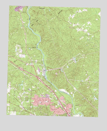
Macon NW, GA USGS Topographic Map
Click on map above to begin viewing in our Map Viewer.

This topographic map contains these locations and features:
Feature Name Type Latitude Longitude GNIS ID View Map
ArkwrightPopulated PlaceN32.9329°W83.7030°354388View Map
Beaverdam CreekStreamN32.9160°W83.6960°311000View Map
BillingwoodPopulated PlaceN32.8960°W83.7299°1672041View Map
Bowman ChurchChurchN32.8899°W83.7463°1672052View Map
Bureau of Alcohol Tobacco Firearms and Explosives Macon I Field OfficeBuildingN32.9006°W83.7030°2734065View Map
Buttlers CreekStreamN32.9812°W83.7205°354923View Map
Calvery ChurchChurchN32.9768°W83.6627°312184View Map
CastlegatePopulated PlaceN32.8829°W83.7382°1672065View Map
Charter Lake HospitalHospitalN32.9007°W83.6868°1672071View Map
Club LakeReservoirN32.9402°W83.6582°312767View Map
Club Lake DamDamN32.9376°W83.6568°340523View Map
Coulters LakeReservoirN32.8956°W83.6275°313017View Map
Coulters Lake DamDamN32.8954°W83.6263°340525View Map
Damascus CemeteryCemeteryN32.9415°W83.7449°313270View Map
Damascus Methodist Episcopal Church (historical)ChurchN32.9418°W83.7455°343038View Map
Eagle LakeReservoirN32.9318°W83.6676°313757View Map
Exit 55CrossingN32.9190°W83.7088°1672114View Map
Exit 55ACrossingN32.9029°W83.6868°1672115View Map
Exit 56CrossingN32.9282°W83.7316°1672116View Map
Forest LakeReservoirN32.8905°W83.7044°314269View Map
Forest LakePopulated PlaceN32.8757°W83.7021°1672126View Map
Frendship ChurchChurchN32.9532°W83.6521°314380View Map
Georgia Farm Bureau Shopping CenterLocaleN32.8849°W83.6735°1672131View Map
Glen CovePopulated PlaceN32.8862°W83.6899°1672135View Map
Glenwood ForestPopulated PlaceN32.8974°W83.7096°1672137View Map
Gorden CemeteryCemeteryN32.9735°W83.6468°314708View Map
Holton Ferry (historical)CrossingN32.9335°W83.7002°345360View Map
Howard School (historical)SchoolN32.8899°W83.7468°1672160View Map
Howell LakeReservoirN32.8987°W83.6304°340408View Map
Howell Lake DamDamN32.8985°W83.6299°340407View Map
Humphries CemeteryCemeteryN32.8979°W83.6427°315819View Map
Ingleside ChurchChurchN32.8854°W83.6763°334788View Map
Jones County Fire Department Station 6BuildingN32.9460°W83.6473°2604887View Map
Jones County Station 6BuildingN32.9801°W83.6633°2625436View Map
Kings ChapelChurchN32.8932°W83.6355°316446View Map
Lake Deer RunReservoirN32.9267°W83.6755°313425View Map
Lake Deer Run DamDamN32.9287°W83.6768°340405View Map
LokchapeePopulated PlaceN32.8835°W83.7027°1672197View Map
Lundies Chapel (historical)ChurchN32.9040°W83.7166°1672199View Map
Lundy ChapelChurchN32.9090°W83.7121°317490View Map
Macon - Bibb County Fire Department Station 103BuildingN32.9043°W83.7224°2604251View Map
Macon - Bibb County Fire Department Station 11BuildingN32.8873°W83.6747°2604246View Map
Macon Behavioral Health Treatment CenterBuildingN32.8933°W83.6806°2611017View Map
Macon QuarryMineN32.9936°W83.7394°2563630View Map
McKay CemeteryCemeteryN32.9607°W83.6341°317934View Map
McKibben LanePopulated PlaceN32.8937°W83.6957°1672218View Map
McKibben Lane SchoolSchoolN32.8915°W83.6941°317943View Map
Monroe County Fire Department Station 7BuildingN32.9928°W83.7318°2604807View Map
Mount Pleasant ChurchChurchN32.9685°W83.6410°318847View Map
New Piney Grove Church (historical)ChurchN32.8921°W83.6810°334789View Map
Northgate Village Shopping CenterLocaleN32.8887°W83.6771°1672240View Map
Northside ChurchChurchN32.9035°W83.7202°1672241View Map
Northwoods Shopping CenterLocaleN32.8985°W83.7018°1672244View Map
Park Memorial United Methodist ChurchChurchN32.9326°W83.7035°1672248View Map
Parker (historical)Populated PlaceN32.9562°W83.7116°343087View Map
Pine ForestPopulated PlaceN32.8871°W83.6646°1672252View Map
Piney Grove Church (historical)ChurchN32.9224°W83.7405°1672254View Map
Plentitude (historical)Populated PlaceN32.9685°W83.6416°345387View Map
Plentitude ChurchChurchN32.9682°W83.6402°320948View Map
Popes FerryLocaleN32.9937°W83.7316°321021View Map
Popes Ferry (historical)CrossingN32.9940°W83.7246°345388View Map
Pratts CreekStreamN32.9696°W83.7146°321126View Map
Rehabilitation Hospital Navicent HealthHospitalN32.8933°W83.6805°2610995View Map
River North Country ClubLocaleN32.9396°W83.6618°344330View Map
Riverside ParkPopulated PlaceN32.8960°W83.6749°1672264View Map
Riverside Shopping CenterLocaleN32.8760°W83.6666°1672265View Map
RiverviewPopulated PlaceN32.8787°W83.6613°1672266View Map
Rivoli (historical)Populated PlaceN32.8768°W83.7146°1672267View Map
Rivoli LakeReservoirN32.9132°W83.7294°340939View Map
Rivoli Lake DamDamN32.9118°W83.7299°340938View Map
Rivoli LakesReservoirN32.9100°W83.7295°321659View Map
Rosa Taylor SchoolSchoolN32.8762°W83.6780°321897View Map
Rum CreekStreamN32.9976°W83.7235°329544View Map
Sabbath CreekStreamN32.9026°W83.6752°322030View Map
Saint Marys Church (historical)ChurchN32.9343°W83.7057°334790View Map
Salem CemeteryCemeteryN32.9849°W83.6785°322332View Map
Sardis CemeteryCemeteryN32.9812°W83.6646°345393View Map
Sardis ChurchChurchN32.9812°W83.6646°322542View Map
Savage BranchStreamN32.8751°W83.6616°322586View Map
Springdale SchoolSchoolN32.9049°W83.7199°323453View Map
Stratford OaksPopulated PlaceN32.8885°W83.7110°1672299View Map
Summerfield School (historical)SchoolN32.9087°W83.7116°1672301View Map
Tattnal Square AcademySchoolN32.8918°W83.7213°323930View Map
ThornwoodPopulated PlaceN32.8810°W83.6735°1672313View Map
Three PointsPopulated PlaceN32.9712°W83.6402°345396View Map
Three Points School (historical)SchoolN32.9143°W83.6377°345397View Map
Tobler CreekStreamN32.9771°W83.7235°356594View Map
Toms FordCrossingN32.9774°W83.7230°1705039View Map
Toms ShoalsBarN32.9774°W83.7230°1705040View Map
Town CreekStreamN32.8962°W83.6605°324247View Map
WesleyanPopulated PlaceN32.8779°W83.7174°334791View Map
Wesleyan College Police DepartmentBuildingN32.8750°W83.7158°2733995View Map
Wesleyan EstatesPopulated PlaceN32.8940°W83.7227°1672340View Map
Wesleyan HillsPopulated PlaceN32.9179°W83.7224°1672341View Map
Wesleyan WoodsPopulated PlaceN32.8829°W83.7199°1672342View Map
Whitehouse PlantationPopulated PlaceN32.9001°W83.7238°1672353View Map
Wimbish HillsPopulated PlaceN32.8793°W83.6832°1672359View Map
Wimbish WoodPopulated PlaceN32.8826°W83.6874°1672360View Map
WMAZ-AM (Macon)TowerN32.8851°W83.7305°352480View Map
WoodcrestPopulated PlaceN32.9090°W83.7435°1672362View Map

Note: Coordinates in the location and feature list above are referenced to NAD83 datum.


Copyright (C) 2008-2024 Ryan Niemi / Sunset Dynamics ... All Rights Reserved