TopoQuest Logo
Do you find TopoQuest useful?
Help keep TopoQuest running and adding new maps/features by donating!
Bitcoin:  19c7KJd3qBynnjoSw5npx9KScwjBe4ifkT
Litecoin:  LXs6TkuXGGXo1vDsWCkWVdjQX94eUKd6ui
Home View Maps Find Maps Find Places Resources & Links


Madison East, Indiana Topographic Map

USGS Map Title: Madison East, IN
USGS Map MRC: 38085F3
DRG (GeoTIFF) Download: o38085f3.tif


Neighboring USGS Topographic Map Quads:


  Clifty Falls, IN  
38085G4
 

  Canaan, IN  
38085G3
 

  Bennington, IN  
38085G2
 

  Madison West, IN  
38085F4
 

  Madison East, IN  
38085F3
 

  Carrollton, KY  
38085F2
 

  Bethlehem, IN  
38085E4
 

  Bedford, KY  
38085E3
 

  Campbellsburg, KY  
38085E2


Map MRC Location:

N39°
W86°
N39°
W85°
H8 H7 H6 H5 H4 H3 H2 H1
G8 G7 G6 G5 G4 G3 G2 G1
F8 F7 F6 F5 F4 F3 F2 F1
E8 E7 E6 E5 E4 E3 E2 E1
D8 D7 D6 D5 D4 D3 D2 D1
C8 C7 C6 C5 C4 C3 C2 C1
B8 B7 B6 B5 B4 B3 B2 B1
A8 A7 A6 A5 A4 A3 A2 A1
N38°
W86°
N38°
W85°

Madison East, IN USGS 1:24K Topographic Map Preview:
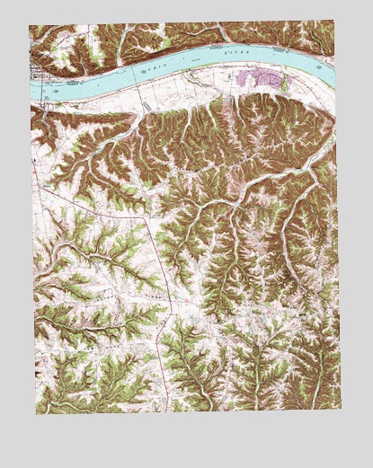
Madison East, IN USGS Topographic Map
Click on map above to begin viewing in our Map Viewer.

This topographic map contains these locations and features:
Feature Name Type Latitude Longitude GNIS ID View Map
Bee Camp CreekStreamN38.7428°W85.2933°430704View Map
Big Cedar CliffsCliffN38.7406°W85.3205°431020View Map
Brook HollowValleyN38.7413°W85.2690°431567View Map
Callis GrovePopulated PlaceN38.6446°W85.3252°2742518View Map
Callis Grove CampgroundLocaleN38.6434°W85.3275°488625View Map
Canip CreekStreamN38.7256°W85.3627°488879View Map
Cedar Cliffs ParkParkN38.7367°W85.3458°432264View Map
City of MiltonCivilN38.7123°W85.3741°2404268View Map
DeWeese CreekStreamN38.7359°W85.2702°490714View Map
Dugan HollowValleyN38.7439°W85.3740°433757View Map
Eagle HollowValleyN38.7360°W85.3383°433847View Map
Eagle Hollow CreekStreamN38.7359°W85.3386°446734View Map
East Prong Locust CreekStreamN38.7023°W85.2622°491499View Map
Fairview (historical)Populated PlaceN38.7032°W85.2938°2742152View Map
Fairview RidgeRidgeN38.7034°W85.2986°491930View Map
Fishers RidgeRidgeN38.6367°W85.2958°492123View Map
Hampton CreekStreamN38.7356°W85.3097°493657View Map
Hardscrabble HollowValleyN38.7484°W85.2975°435734View Map
Hopewell ChurchChurchN38.7023°W85.2638°494537View Map
Hopewell Methodist Episcopal Church South (historical)ChurchN38.7319°W85.2690°2565051View Map
Hunters BottomFlatN38.7322°W85.2849°2565052View Map
Hunters BottomFlatN38.7246°W85.3397°2742523View Map
Leeport RidgeRidgeN38.6617°W85.3358°496179View Map
LocustPopulated PlaceN38.7031°W85.2608°508485View Map
Locust Baptist Church (historical)ChurchN38.6987°W85.2581°2565026View Map
Locust Post Office (historical)Post OfficeN38.7014°W85.2613°2565028View Map
Locust School (historical)SchoolN38.7029°W85.2608°2565029View Map
Lonesome HollowValleyN38.7335°W85.3520°438242View Map
Madison BridgeBridgeN38.7292°W85.3702°446738View Map
MiltonPopulated PlaceN38.7237°W85.3694°498397View Map
Milton Volunteer Fire and Rescue Station 2BuildingN38.6566°W85.3183°2637406View Map
Moffett CemeteryCemeteryN38.7214°W85.3744°498469View Map
MonitorPopulated PlaceN38.6548°W85.2663°508625View Map
Monroe HollowValleyN38.7421°W85.2736°439344View Map
Mount Carmel ChurchChurchN38.6876°W85.3261°498713View Map
Mount Herman ChurchChurchN38.6570°W85.2563°498746View Map
Mount Tabor (historical)Populated PlaceN38.6529°W85.2996°2742526View Map
New Hope RidgeRidgeN38.6459°W85.3391°499362View Map
North Mount Tabor (historical)Populated PlaceN38.6743°W85.3027°2742527View Map
Panther RunStreamN38.6934°W85.2639°2565060View Map
Pilgrim Holiness ChurchChurchN38.7342°W85.3664°2740651View Map
Saint Johns United Church of ChristChurchN38.7367°W85.3742°2740516View Map
Saint Peters ChurchChurchN38.7356°W85.2944°502725View Map
School Number Nineteen (historical)SchoolN38.6994°W85.2585°2565067View Map
School Number Thirty-Three (historical)SchoolN38.7040°W85.2934°2565069View Map
Shirks HollowValleyN38.7369°W85.2549°443420View Map
South Mount Tabor (historical)Populated PlaceN38.6473°W85.2969°2742529View Map
Tiber CreekStreamN38.7261°W85.3682°505265View Map
Trimble County Emergency Medical ServicesBuildingN38.6574°W85.3182°2719136View Map
Union Grove ChurchChurchN38.6562°W85.2819°505799View Map
WCJC-FM (Madison)TowerN38.7426°W85.3616°448920View Map
West Prong Locust CreekStreamN38.7023°W85.2619°506473View Map
WORX-AM (Madison)TowerN38.7412°W85.3613°448469View Map
Wrights RidgeRidgeN38.6709°W85.2580°507171View Map
Wrights Ridge (historical)Populated PlaceN38.6754°W85.2566°2742168View Map

Note: Coordinates in the location and feature list above are referenced to NAD83 datum.


Copyright (C) 2008-2025 Ryan Niemi / Sunset Dynamics ... All Rights Reserved