TopoQuest Logo
Do you find TopoQuest useful?
Help keep TopoQuest running and adding new maps/features by donating!
Bitcoin:  19c7KJd3qBynnjoSw5npx9KScwjBe4ifkT
Litecoin:  LXs6TkuXGGXo1vDsWCkWVdjQX94eUKd6ui
Home View Maps Find Maps Find Places Resources & Links


Madison West, Indiana Topographic Map

USGS Map Title: Madison West, IN
USGS Map MRC: 38085F4
DRG (GeoTIFF) Download: o38085f4.tif


Neighboring USGS Topographic Map Quads:


  Volga, IN  
38085G5
 

  Clifty Falls, IN  
38085G4
 

  Canaan, IN  
38085G3
 

  Kent, IN  
38085F5
 

  Madison West, IN  
38085F4
 

  Madison East, IN  
38085F3
 

  New Washington, IN  
38085E5
 

  Bethlehem, IN  
38085E4
 

  Bedford, KY  
38085E3


Map MRC Location:

N39°
W86°
N39°
W85°
H8 H7 H6 H5 H4 H3 H2 H1
G8 G7 G6 G5 G4 G3 G2 G1
F8 F7 F6 F5 F4 F3 F2 F1
E8 E7 E6 E5 E4 E3 E2 E1
D8 D7 D6 D5 D4 D3 D2 D1
C8 C7 C6 C5 C4 C3 C2 C1
B8 B7 B6 B5 B4 B3 B2 B1
A8 A7 A6 A5 A4 A3 A2 A1
N38°
W86°
N38°
W85°

Madison West, IN USGS 1:24K Topographic Map Preview:
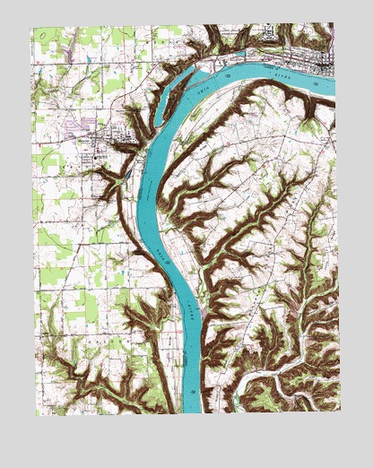
Madison West, IN USGS Topographic Map
Click on map above to begin viewing in our Map Viewer.

This topographic map contains these locations and features:
Feature Name Type Latitude Longitude GNIS ID View Map
Antioch GrangePopulated PlaceN38.7373°W85.4702°430218View Map
Big Clifty CreekStreamN38.7342°W85.4241°431023View Map
Broadway HollowValleyN38.7264°W85.3854°487940View Map
Butler FallsFallsN38.7034°W85.4736°431903View Map
Chain Mill CreekStreamN38.6931°W85.4572°432380View Map
Chain Mill FallsFallsN38.6945°W85.4719°432381View Map
Christ Episcopal ChurchChurchN38.7378°W85.3786°2740515View Map
Clifty Creek Power PlantLocaleN38.7373°W85.4150°452293View Map
Cooper CreekStreamN38.7131°W85.4416°490055View Map
Coopers BottomFlatN38.7218°W85.4298°2742519View Map
Crooked CreekStreamN38.7373°W85.4116°433161View Map
Crowe FallsFallsN38.7112°W85.4641°433204View Map
Deadman FallsFallsN38.7231°W85.4591°433389View Map
Delia Webster Historical MarkerParkN38.7102°W85.3798°2744787View Map
Devils BackboneRidgeN38.7273°W85.4402°433503View Map
Faith Covenant ChurchChurchN38.7375°W85.3781°2740514View Map
Farley CreekStreamN38.6592°W85.4405°434391View Map
First Baptist ChurchChurchN38.7381°W85.3853°2740519View Map
First Christian ChurchChurchN38.7375°W85.3853°2740518View Map
Fisher RidgeRidgeN38.6995°W85.4100°492121View Map
Fremont FallsFallsN38.6939°W85.4691°434826View Map
Furnace BranchStreamN38.6603°W85.3883°492627View Map
Gilmore CreekStreamN38.6834°W85.4480°492854View Map
Greenbriar CemeteryCemeteryN38.7237°W85.4891°435422View Map
HanoverPopulated PlaceN38.7142°W85.4736°435696View Map
Hanover BeachPopulated PlaceN38.7067°W85.4533°452049View Map
Hanover CemeteryCemeteryN38.7095°W85.4642°435697View Map
Hanover ChurchChurchN38.7181°W85.4700°435698View Map
Hanover CollegeSchoolN38.7123°W85.4608°449666View Map
Hanover Landing (historical)LocaleN38.7128°W85.4513°448375View Map
Hanover Police DepartmentBuildingN38.7141°W85.4670°2758097View Map
Hanover Volunteer Fire CompanyBuildingN38.7129°W85.4819°2625684View Map
Happy Valley CreekStreamN38.7089°W85.4525°435717View Map
Harts FallsFallsN38.6770°W85.4583°435836View Map
Harts Falls CreekStreamN38.6787°W85.4538°435837View Map
Horseshoe FallsFallsN38.7231°W85.4569°436494View Map
Hughes CreekStreamN38.6495°W85.3913°494749View Map
James F D Lanier MemorialParkN38.7351°W85.3861°447651View Map
Jefferson County SheriffBuildingN38.7359°W85.3759°2758479View Map
Joyce RidgeRidgeN38.6781°W85.3780°495537View Map
Lee BottomFlatN38.6451°W85.4444°437728View Map
Lee Bottom AirportAirportN38.6324°W85.4429°2676956View Map
Lee CreekStreamN38.6553°W85.4394°437733View Map
Liberty RidgeRidgeN38.7114°W85.4250°496388View Map
Little Crooked CreekStreamN38.7403°W85.4113°438035View Map
Little Grand Theatre (historical)BuildingN38.7367°W85.3797°2740510View Map
MadisonPopulated PlaceN38.7359°W85.3800°438468View Map
Madison - Jefferson County Public LibraryBuildingN38.7372°W85.3842°2740512View Map
Madison Country ClubLocaleN38.7401°W85.4075°452356View Map
Madison Juvenile Correctional FacilityBuildingN38.7479°W85.4019°2757193View Map
Madison Police DepartmentBuildingN38.7361°W85.3804°2758171View Map
Madison Presbyterian ChurchChurchN38.7353°W85.3831°2740513View Map
Madison State HospitalHospitalN38.7479°W85.4021°438472View Map
Madison Theatre (historical)BuildingN38.7367°W85.3817°2740511View Map
Madison Volunteer Fire Department - Western Fire Company 3BuildingN38.7382°W85.3916°2625554View Map
Madison Volunteer Fire Department Fairplay Fire Company 1BuildingN38.7365°W85.3754°2625845View Map
Madison Volunteer Fire Department Walnut Street Fire Company 4BuildingN38.7373°W85.3755°2625756View Map
Madison Volunteer Fire Department Washington Engine Fire Company 2BuildingN38.7377°W85.3805°2625550View Map
McIntire CemeteryCemeteryN38.7070°W85.4105°497885View Map
Milton ChurchChurchN38.7134°W85.3766°498398View Map
Milton DivisionCivilN38.6829°W85.3763°1937149View Map
Milton HillSummitN38.7208°W85.3794°2742524View Map
Milton Volunteer Fire and RescueBuildingN38.7184°W85.3810°2636441View Map
Moreland CreekStreamN38.6537°W85.4311°498578View Map
Mount Bryd ChurchChurchN38.7117°W85.3777°498691View Map
Mount ByrdSummitN38.7127°W85.3808°2742525View Map
New LondonLocaleN38.6523°W85.4411°452181View Map
New Prospect ChurchChurchN38.6514°W85.4602°440101View Map
Norfolk ChurchChurchN38.6320°W85.4183°499519View Map
Ohio TheatreBuildingN38.7367°W85.3797°2740509View Map
Old Bethel CemeteryCemeteryN38.6865°W85.4677°440535View Map
Page CreekStreamN38.7320°W85.4127°500111View Map
Pleasant Retreat RidgeRidgeN38.6803°W85.3966°500887View Map
Preston HollowValleyN38.6316°W85.4325°501304View Map
Pryors ForkStreamN38.6365°W85.4019°501406View Map
Rider LakeReservoirN38.7428°W85.4833°446739View Map
Rodgers RidgeRidgeN38.6337°W85.4241°502269View Map
SaludaPopulated PlaceN38.6506°W85.4850°446878View Map
Southwestern Elementary SchoolSchoolN38.7081°W85.4738°443896View Map
Southwestern High SchoolSchoolN38.7103°W85.4733°443894View Map
Spring CreekStreamN38.6626°W85.4336°504127View Map
Spring Creek BottomFlatN38.6633°W85.4338°2742532View Map
Springdale CemeteryCemeteryN38.7416°W85.3881°444003View Map
Town of HanoverCivilN38.7137°W85.4724°2396984View Map
Township of HanoverCivilN38.7047°W85.4922°453370View Map
Trinity United Methodist ChurchChurchN38.7375°W85.3836°2740517View Map
TroutPopulated PlaceN38.6387°W85.4088°509238View Map
Trout CemeteryCemeteryN38.6773°W85.4305°505519View Map
Trout RidgeRidgeN38.6759°W85.4306°2742533View Map
Zion CemeteryCemeteryN38.6282°W85.4895°446443View Map
Zoar ChurchChurchN38.7351°W85.4986°446493View Map

Note: Coordinates in the location and feature list above are referenced to NAD83 datum.


Copyright (C) 2008-2024 Ryan Niemi / Sunset Dynamics ... All Rights Reserved