TopoQuest Logo
Do you find TopoQuest useful?
Help keep TopoQuest running and adding new maps/features by donating!
Bitcoin:  19c7KJd3qBynnjoSw5npx9KScwjBe4ifkT
Litecoin:  LXs6TkuXGGXo1vDsWCkWVdjQX94eUKd6ui
Home View Maps Find Maps Find Places Resources & Links


Magdalena, New Mexico Topographic Map

USGS Map Title: Magdalena, NM
USGS Map MRC: 34107A2
DRG (GeoTIFF) Download: o34107a2.tif


Neighboring USGS Topographic Map Quads:


  Silver Hill, NM  
34107B3
 

  Granite Mountain, NM  
34107B2
 

  San Lorenzo Spring, NM  
34107B1
 

  Arroyo Landavaso, NM  
34107A3
 

  Magdalena, NM  
34107A2
 

  Water Canyon, NM  
34107A1
 

  Squaw Peak, NM  
33107H3
 

  South Baldy, NM  
33107H2
 

  Molino Peak, NM  
33107H1


Map MRC Location:

N35°
W108°
N35°
W107°
H8 H7 H6 H5 H4 H3 H2 H1
G8 G7 G6 G5 G4 G3 G2 G1
F8 F7 F6 F5 F4 F3 F2 F1
E8 E7 E6 E5 E4 E3 E2 E1
D8 D7 D6 D5 D4 D3 D2 D1
C8 C7 C6 C5 C4 C3 C2 C1
B8 B7 B6 B5 B4 B3 B2 B1
A8 A7 A6 A5 A4 A3 A2 A1
N34°
W108°
N34°
W107°

Magdalena, NM USGS 1:24K Topographic Map Preview:
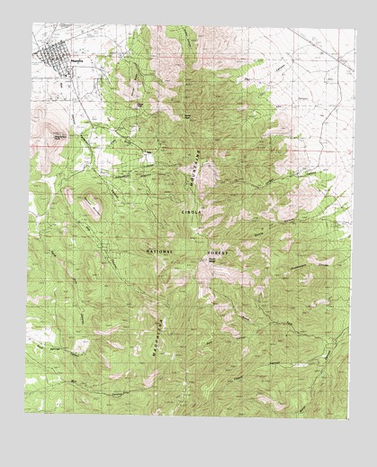
Magdalena, NM USGS Topographic Map
Click on map above to begin viewing in our Map Viewer.

This topographic map contains these locations and features:
Feature Name Type Latitude Longitude GNIS ID View Map
Agua Fria SpringSpringN34.0273°W107.2123°1989996View Map
Alamo Navajo SchoolSchoolN34.1167°W107.2439°934063View Map
Alamo School Pueblo Historic SiteLocaleN34.1167°W107.2439°934271View Map
AmbrosiaMineN34.1023°W107.1914°915737View Map
Ambrosia MineMineN34.1020°W107.1928°901667View Map
AnchorMineN34.1195°W107.1895°915738View Map
Anchor MineMineN34.1198°W107.1909°901666View Map
Aqua Fria SpringSpringN34.0270°W107.2120°937079View Map
Aragon House Historic SiteBuildingN34.1167°W107.2439°933533View Map
AT and SF RR DepotBuildingN34.1167°W107.2439°933350View Map
Baxter PeakSummitN34.0992°W107.2089°1989993View Map
Black Cloud and Mistletoe MineMineN34.0756°W107.1895°940010View Map
Black Cloud MineMineN34.0770°W107.1895°901670View Map
Buckeye MineMineN34.0178°W107.1350°904144View Map
Cabin SpringSpringN34.0386°W107.1641°914118View Map
CavalierMineN34.1056°W107.2409°917183View Map
Cavern and Grand Ledge MineMineN34.0640°W107.1903°940012View Map
Cavern TunnelMineN34.0640°W107.1881°901485View Map
Charles Ilfield Company Warehouse Historic SiteBuildingN34.1167°W107.2439°935164View Map
Chihuahua GulchValleyN34.0751°W107.2234°905092View Map
Cimarron TunnelMineN34.0915°W107.2000°901473View Map
Clemens Ranch House Historic SiteBuildingN34.0831°W107.2053°933787View Map
Community ChurchChurchN34.1167°W107.2439°920295View Map
ConnellyMineN34.0584°W107.1906°915730View Map
Connelly TunnelMineN34.0584°W107.1895°901487View Map
Contact ShaftMineN34.0842°W107.2034°902511View Map
Copper CanyonValleyN34.0198°W107.1334°905322View Map
Courtney RanchLocaleN34.1078°W107.1356°905442View Map
Crown MillBuildingN34.1167°W107.2439°935661View Map
Dark CanyonValleyN34.0298°W107.1584°905598View Map
Dobson House Historic SiteBuildingN34.1167°W107.2439°935176View Map
Earth TankReservoirN34.0556°W107.2325°914030View Map
Earth TankReservoirN34.1100°W107.1531°914045View Map
Elephant MountainSummitN34.0687°W107.2264°906113View Map
Elephant SpringSpringN34.0634°W107.2178°937097View Map
Ellis CabinLocaleN34.0420°W107.1800°914117View Map
Ellis CanyonValleyN34.1106°W107.1370°906136View Map
Enterprise TunnelMineN34.0695°W107.1886°901484View Map
Enterprise TunnelsMineN34.0698°W107.1895°916552View Map
First Baptist ChurchChurchN34.1167°W107.2439°921153View Map
Frenchies CabinLocaleN34.0087°W107.2014°906398View Map
Gallinas Spring Historic SiteLocaleN34.1167°W107.2439°933732View Map
Garcia Canyon SpringSpringN34.0648°W107.1481°902636View Map
Garcia Canyon SpringSpringN34.0581°W107.1637°914120View Map
Garcia Canyon WellWellN34.0640°W107.1364°914047View Map
GermanyMineN34.0862°W107.1964°915733View Map
Germany MinesMineN34.0851°W107.1936°901669View Map
Grand Ledge TunnelMineN34.0465°W107.1881°901486View Map
Grand Tower and Legal TenderMineN34.0895°W107.1964°915734View Map
Grand Tower ShaftMineN34.0903°W107.1964°901477View Map
Graphic and Martin TunnelsMineN34.0956°W107.2039°916553View Map
Graphic ShaftMineN34.0962°W107.2048°938816View Map
Graphic WaldoMineN34.0917°W107.2098°917184View Map
Greyhound TunnelMineN34.0920°W107.2039°901475View Map
Gutierrez House Historic SiteBuildingN34.1167°W107.2439°933413View Map
Hall Hotel Historic SiteBuildingN34.1167°W107.2439°933774View Map
HardscrabbleMineN34.1120°W107.1948°915752View Map
Hardscrabble CampLocaleN34.1126°W107.2117°902053View Map
Hardscrabble MineMineN34.1137°W107.1981°906841View Map
Hell CanyonValleyN34.1245°W107.1336°906906View Map
Hell Canyon SpringSpringN34.1041°W107.1821°1989994View Map
Hell Canyon TankReservoirN34.1072°W107.1619°913889View Map
Hermit MineMineN34.1117°W107.1984°915748View Map
Hilton House Historic SiteBuildingN34.1167°W107.2439°933751View Map
Hop CanyonValleyN34.1092°W107.2423°907078View Map
Hop Canyon Fire StationBuildingN34.0765°W107.2393°2658019View Map
Hop Canyon WellWellN34.0623°W107.2286°914031View Map
Ida Hill TunnelMineN34.0917°W107.2048°901476View Map
Iron MaskMineN34.0665°W107.2100°915749View Map
Iron Mask ShaftMineN34.0662°W107.2095°901672View Map
Juanita TunnelMineN34.0840°W107.1992°901481View Map
KellyPopulated PlaceN34.0831°W107.2053°907521View Map
Kelly GulchValleyN34.0923°W107.2339°907526View Map
Kelly MineMineN34.1167°W107.2439°935737View Map
Kelly Post Office (historical)Post OfficeN34.0831°W107.2053°938296View Map
Kelly TunnelMineN34.0867°W107.1995°901478View Map
Key MineMineN34.0978°W107.1903°901668View Map
Linchberg MineMineN34.0717°W107.1889°907967View Map
Linchburg MineMineN34.0692°W107.1948°939754View Map
Linchburg TunnelMineN34.0687°W107.1942°901483View Map
Little LoellaMineN34.0828°W107.1923°915747View Map
Little TankReservoirN34.1031°W107.1617°913890View Map
M 12 Water WellWellN34.1209°W107.2311°925875View Map
MagdalenaPopulated PlaceN34.1167°W107.2439°908353View Map
Magdalena Bank Building Historic SiteBuildingN34.1167°W107.2439°934467View Map
Magdalena City MarshalBuildingN34.1187°W107.2434°2722580View Map
Magdalena Elementary SchoolSchoolN34.1167°W107.2439°933899View Map
Magdalena Fault Historical MarkerParkN34.1167°W107.2439°932341View Map
Magdalena Fire and RescueBuildingN34.1168°W107.2450°2658098View Map
Magdalena High SchoolSchoolN34.1167°W107.2439°901372View Map
Magdalena Historic DistrictLocaleN34.1167°W107.2439°934445View Map
Magdalena Historical MarkerParkN34.1167°W107.2439°932389View Map
Magdalena House Historic SiteBuildingN34.1167°W107.2439°934451View Map
Magdalena Middle SchoolSchoolN34.1167°W107.2439°901373View Map
Magdalena MountainsRangeN34.0484°W107.1853°908355View Map
Magdalena Municipal Water ShedSpringN34.0376°W107.2034°914284View Map
Magdalena PeakSummitN34.0884°W107.2411°908356View Map
Magdalena Post OfficePost OfficeN34.1197°W107.2370°938220View Map
Magdalena Ranger StationLocaleN34.1167°W107.2406°913895View Map
Magdalena Stock Driveway Historic SiteTrailN34.1167°W107.2439°934300View Map
Magdalena Weather StationLocaleN34.1167°W107.2439°931852View Map
Manganese QueenMineN34.0253°W107.1278°916455View Map
Martin TunnelMineN34.0956°W107.2050°901467View Map
McDonald SpringSpringN34.0665°W107.2136°914032View Map
Mill CanyonSpringN34.0091°W107.2004°902647View Map
Mistletoe GulchValleyN34.0759°W107.2114°908806View Map
Mistletoe MineMineN34.0756°W107.1895°901671View Map
Mistletoe TunnelMineN34.0778°W107.1953°901482View Map
Mitchell TunnelMineN34.0917°W107.2020°901474View Map
Mockingbird MineMineN34.1062°W107.2070°915735View Map
Morning StarMineN34.0723°W107.2089°917177View Map
NittMineN34.0962°W107.2070°917178View Map
Nitt ShaftMineN34.0959°W107.2084°901641View Map
North BaldySummitN34.0503°W107.1811°909123View Map
North Fork Water CanyonValleyN34.0256°W107.1289°909159View Map
North PeakSummitN34.0962°W107.1906°909174View Map
Oak SpringSpringN34.1020°W107.1998°901423View Map
Papa RanchLocaleN34.0781°W107.1459°909475View Map
Paschal ShaftMineN34.0878°W107.2014°909488View Map
Patterson CanyonValleyN34.0890°W107.2317°909507View Map
Pony SpringSpringN34.0728°W107.2053°1989995View Map
Pony SpringSpringN34.0730°W107.2054°914121View Map
Quail TankReservoirN34.0972°W107.1378°914046View Map
RG 28100 Water WellWellN34.0737°W107.2389°925763View Map
RG 33524 Water WellWellN34.0667°W107.1359°925778View Map
RG 33603 Water WellWellN34.0473°W107.2200°925540View Map
RG 42197 Water WellWellN34.0648°W107.2339°925775View Map
RG 42224 Water WellWellN34.0162°W107.1478°925789View Map
Rock SpringsSpringN34.0206°W107.2239°914368View Map
Rowden TankReservoirN34.0030°W107.2372°913886View Map
S Strozzi RanchLocaleN34.0634°W107.1259°910488View Map
Salome StoreBuildingN34.1167°W107.2439°935985View Map
Salome Store WarehouseBuildingN34.1167°W107.2433°935963View Map
SampsonMineN34.0931°W107.1984°915742View Map
Shakespeare SpringSpringN34.0489°W107.1427°900265View Map
SleeperMineN34.0978°W107.1978°915744View Map
Sleeper TunnelMineN34.0978°W107.1992°901468View Map
Smith TunnelMineN34.0570°W107.2050°901488View Map
South JuanitaMineN34.0817°W107.1959°915741View Map
South Juanita ShaftMineN34.0815°W107.1956°902091View Map
SRF 14 Water WellWellN34.1120°W107.1356°925885View Map
SRF 2 Water WellWellN34.0667°W107.1359°925777View Map
StendelMineN34.0470°W107.2286°915736View Map
Stendel RidgeRidgeN34.1084°W107.2117°897536View Map
StonewallMineN34.0937°W107.1911°917179View Map
Stonewall TunnelMineN34.0601°W107.1909°901470View Map
Strozzi Su SpringSpringN34.0628°W107.1485°900264View Map
Taylor ShaftMineN34.0853°W107.2014°901479View Map
Tip Top MineMineN34.0934°W107.1928°940006View Map
Tip Top MountainSummitN34.0959°W107.1909°901469View Map
TIp Top SpringSpringN34.1081°W107.1634°913888View Map
Tip Top TunnelMineN34.0931°W107.1703°901472View Map
Traylor ShaftMineN34.0856°W107.2014°916545View Map
Tri Bullion MineMineN34.0851°W107.2014°901480View Map
Tri Bullon ShaftMineN34.0865°W107.2011°911811View Map
Unity TunnelMineN34.0551°W107.1964°916548View Map
Upper Garcia Canyon SpringSpringN34.0527°W107.1743°914119View Map
Village of MagdalenaCivilN34.1094°W107.2317°2413570View Map
Vindicator MineMineN34.1148°W107.2056°940008View Map
Vindicator ShaftMineN34.1153°W107.2067°901534View Map
Waldo ShaftMineN34.0920°W107.2070°901520View Map
Waldo TunnelMineN34.0928°W107.2095°912133View Map
Water Canyon CampgroundLocaleN34.0242°W107.1303°900186View Map
West Virginia MineMineN34.1148°W107.2056°940009View Map
West Virginia TunnelMineN34.0562°W107.1881°901522View Map
WoodlandMineN34.0651°W107.1867°917180View Map
Woodland MineMineN34.0648°W107.1859°901521View Map
Young AmericaMineN34.0687°W107.1900°915755View Map
Young America MineMineN34.0681°W107.1900°937142View Map
ZamoraLocaleN34.0203°W107.2264°913887View Map

Note: Coordinates in the location and feature list above are referenced to NAD83 datum.


Copyright (C) 2008-2025 Ryan Niemi / Sunset Dynamics ... All Rights Reserved