TopoQuest Logo
Do you find TopoQuest useful?
Help keep TopoQuest running and adding new maps/features by donating!
Bitcoin:  19c7KJd3qBynnjoSw5npx9KScwjBe4ifkT
Litecoin:  LXs6TkuXGGXo1vDsWCkWVdjQX94eUKd6ui
Home View Maps Find Maps Find Places Resources & Links


Molino Peak, New Mexico Topographic Map

USGS Map Title: Molino Peak, NM
USGS Map MRC: 33107H1
DRG (GeoTIFF) Download: o33107h1.tif


Neighboring USGS Topographic Map Quads:


  Magdalena, NM  
34107A2
 

  Water Canyon, NM  
34107A1
 

  Socorro, NM  
34106A8
 

  South Baldy, NM  
33107H2
 

  Molino Peak, NM  
33107H1
 

  Luis Lopez, NM  
33106H8
 

  Puertecito Gap, NM  
33107G2
 

  Cienega Ranch, NM  
33107G1
 

  Indian Well Wilderness, NM  
33106G8


Map MRC Location:

N34°
W108°
N34°
W107°
H8 H7 H6 H5 H4 H3 H2 H1
G8 G7 G6 G5 G4 G3 G2 G1
F8 F7 F6 F5 F4 F3 F2 F1
E8 E7 E6 E5 E4 E3 E2 E1
D8 D7 D6 D5 D4 D3 D2 D1
C8 C7 C6 C5 C4 C3 C2 C1
B8 B7 B6 B5 B4 B3 B2 B1
A8 A7 A6 A5 A4 A3 A2 A1
N33°
W108°
N33°
W107°

Molino Peak, NM USGS 1:24K Topographic Map Preview:
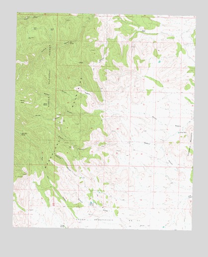
Molino Peak, NM USGS Topographic Map
Click on map above to begin viewing in our Map Viewer.

This topographic map contains these locations and features:
Feature Name Type Latitude Longitude GNIS ID View Map
10046 Water WellWellN33.8770°W107.0367°925506View Map
B and R GroupMineN33.9306°W107.1009°917909View Map
Bear Canyon Group MineMineN33.9306°W107.0739°917910View Map
Bear Canyon Group MineMineN33.9815°W107.0606°916454View Map
Bianchi ClaimsMineN33.9270°W107.0734°916452View Map
Black Eagle MineMineN33.9842°W107.0434°939865View Map
Boon WellWellN33.8770°W107.0367°904007View Map
Box SpringSpringN33.9835°W107.0880°904042View Map
Broken TankReservoirN33.9319°W107.0111°904091View Map
Buena VistaMineN33.9042°W107.1231°917475View Map
Burris ClaimsMineN33.8965°W107.1181°916543View Map
Caronita CanyonValleyN33.9048°W107.0764°904784View Map
Chavez CanyonValleyN33.9262°W107.0403°902894View Map
Cienega SpringsSpringN33.8759°W107.0889°905159View Map
Cinega SpringSpringN33.8760°W107.0891°902646View Map
Combs and WoodMineN33.9967°W107.0881°917905View Map
Gay Water TankReservoirN33.9851°W107.1174°906512View Map
Geronimo Claims-Luis Lopez DistrictMineN33.9787°W107.0031°916551View Map
Gianero RanchLocaleN33.9906°W107.0378°906531View Map
JVB ClaimsMineN33.9881°W107.0473°917400View Map
Lower TankReservoirN33.9904°W107.1022°908292View Map
Lucky RidgeMineN33.9351°W107.0778°916541View Map
Lucky Strike Number 2-Luis Lopez D MineMineN33.9842°W107.0011°916446View Map
Manganese ChiefMineN33.9312°W107.0950°916451View Map
Molino CanyonValleyN33.9426°W107.0889°908826View Map
Molino PeakSummitN33.9484°W107.1200°908827View Map
Molino SpringSpringN33.9467°W107.1058°908828View Map
Muncy Headquarters Water WellWellN33.8770°W107.0367°941047View Map
Pedro Armendaris Number 34CivilN33.8806°W107.0506°1990041View Map
Phillips Lease MineMineN33.9976°W107.0567°939866View Map
Red Bluff GroupMineN33.9248°W107.0950°937208View Map
Ryan Hill SpringSpringN33.9292°W107.1207°910485View Map
Sandy ClaimsMineN33.9334°W107.0692°916542View Map
SRF 26 Water WellWellN33.9926°W107.0400°925526View Map
SRF 28 Water WellWellN33.9828°W107.0081°925716View Map
Torreon SpringSpringN33.8890°W107.0636°914367View Map
Torreon SpringsSpringN33.8906°W107.0716°911760View Map
Upper TankReservoirN33.9908°W107.1140°912007View Map

Note: Coordinates in the location and feature list above are referenced to NAD83 datum.


Copyright (C) 2008-2024 Ryan Niemi / Sunset Dynamics ... All Rights Reserved