TopoQuest Logo
Do you find TopoQuest useful?
Help keep TopoQuest running and adding new maps/features by donating!
Bitcoin:  19c7KJd3qBynnjoSw5npx9KScwjBe4ifkT
Litecoin:  LXs6TkuXGGXo1vDsWCkWVdjQX94eUKd6ui
Home View Maps Find Maps Find Places Resources & Links


Magic Reservoir West, Idaho Topographic Map

USGS Map Title: Magic Reservoir West, ID
USGS Map MRC: 43114C4
DRG (GeoTIFF) Download: o43114c4.tif


Neighboring USGS Topographic Map Quads:


  Beaver Creek, ID  
43114D5
 

  Richardson Summit, ID  
43114D4
 

  Bellevue, ID  
43114D3
 

  Macon, ID  
43114C5
 

  Magic Reservoir West, ID  
43114C4
 

  Magic Reservoir East, ID  
43114C3
 

  Thorn Creek Reservoir, ID  
43114B5
 

  Summit Reservoir, ID  
43114B4
 

  Shoshone Ice Cave, ID  
43114B3


Map MRC Location:

N44°
W115°
N44°
W114°
H8 H7 H6 H5 H4 H3 H2 H1
G8 G7 G6 G5 G4 G3 G2 G1
F8 F7 F6 F5 F4 F3 F2 F1
E8 E7 E6 E5 E4 E3 E2 E1
D8 D7 D6 D5 D4 D3 D2 D1
C8 C7 C6 C5 C4 C3 C2 C1
B8 B7 B6 B5 B4 B3 B2 B1
A8 A7 A6 A5 A4 A3 A2 A1
N43°
W115°
N43°
W114°

Magic Reservoir West, ID USGS 1:24K Topographic Map Preview:
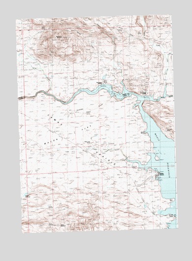
Magic Reservoir West, ID USGS Topographic Map
Click on map above to begin viewing in our Map Viewer.

This topographic map contains these locations and features:
Feature Name Type Latitude Longitude GNIS ID View Map
Barrel SpringSpringN43.3370°W114.4311°371371View Map
Camas CreekStreamN43.3266°W114.4017°378736View Map
Camp CreekStreamN43.3313°W114.4770°378777View Map
Clay Bank SpringSpringN43.3076°W114.3815°372044View Map
Cold SpringSpringN43.3003°W114.4289°372084View Map
Eagle SpringSpringN43.3649°W114.4031°372536View Map
Floyds ReservoirReservoirN43.2540°W114.4775°372736View Map
Grouse ReservoirReservoirN43.2649°W114.4788°395437View Map
Horse MountainSummitN43.2535°W114.4692°373146View Map
Hot Springs LandingLocaleN43.3299°W114.4003°396672View Map
Lava CanyonValleyN43.2913°W114.4145°373520View Map
Lava CreekStreamN43.2913°W114.4145°373522View Map
Little Poison CreekStreamN43.3621°W114.3978°373662View Map
Little Rock CreekStreamN43.3524°W114.3778°373667View Map
Macon FlatFlatN43.3143°W114.4562°373791View Map
MagicPopulated PlaceN43.2552°W114.3867°376170View Map
Magic ReservoirReservoirN43.2836°W114.3777°397888View Map
Magic Reservoir AirportAirportN43.2824°W114.3953°400831View Map
Magic ResortPopulated PlaceN43.2824°W114.3898°396838View Map
Magpie ReservoirReservoirN43.2726°W114.4961°373798View Map
Metcalf SpringSpringN43.3059°W114.3997°373912View Map
Moonstone Access AreaLocaleN43.3360°W114.4273°401625View Map
Moonstone LandingLocaleN43.3357°W114.4320°394785View Map
Moonstone MountainSummitN43.3638°W114.4623°374014View Map
Myrtle PointCapeN43.2666°W114.3787°374092View Map
Northside SloughStreamN43.3280°W114.4253°374235View Map
Northside SpringSpringN43.3191°W114.4512°396972View Map
Pofferman SpringSpringN43.2868°W114.4115°400043View Map
Poison CreekStreamN43.3316°W114.4150°388641View Map
Rock CreekStreamN43.3282°W114.3828°389490View Map
Rock Creek RanchLocaleN43.3602°W114.3895°374724View Map
Roseberry SpringsSpringN43.3660°W114.4125°374779View Map
Rowley RanchLocaleN43.3482°W114.4826°374804View Map
Shirley SpringSpringN43.3689°W114.4765°375006View Map
Spring CreekStreamN43.3457°W114.4214°398166View Map
Water Cress SpringSpringN43.2989°W114.4417°375759View Map
West Magic Fire District Station 1BuildingN43.2705°W114.4104°2619230View Map
West Magic Fire District Station 2BuildingN43.2798°W114.3950°2619229View Map
Wood River Deer Migration CorridorReserveN43.3291°W114.3839°399617View Map

Note: Coordinates in the location and feature list above are referenced to NAD83 datum.


Copyright (C) 2008-2025 Ryan Niemi / Sunset Dynamics ... All Rights Reserved