TopoQuest Logo
Do you find TopoQuest useful?
Help keep TopoQuest running and adding new maps/features by donating!
Bitcoin:  19c7KJd3qBynnjoSw5npx9KScwjBe4ifkT
Litecoin:  LXs6TkuXGGXo1vDsWCkWVdjQX94eUKd6ui
Home View Maps Find Maps Find Places Resources & Links


Magic Reservoir East, Idaho Topographic Map

USGS Map Title: Magic Reservoir East, ID
USGS Map MRC: 43114C3
DRG (GeoTIFF) Download: o43114c3.tif


Neighboring USGS Topographic Map Quads:


  Richardson Summit, ID  
43114D4
 

  Bellevue, ID  
43114D3
 

  Seamans Creek, ID  
43114D2
 

  Magic Reservoir West, ID  
43114C4
 

  Magic Reservoir East, ID  
43114C3
 

  Gannett, ID  
43114C2
 

  Summit Reservoir, ID  
43114B4
 

  Shoshone Ice Cave, ID  
43114B3
 

  Tapper Lake, ID  
43114B2


Map MRC Location:

N44°
W115°
N44°
W114°
H8 H7 H6 H5 H4 H3 H2 H1
G8 G7 G6 G5 G4 G3 G2 G1
F8 F7 F6 F5 F4 F3 F2 F1
E8 E7 E6 E5 E4 E3 E2 E1
D8 D7 D6 D5 D4 D3 D2 D1
C8 C7 C6 C5 C4 C3 C2 C1
B8 B7 B6 B5 B4 B3 B2 B1
A8 A7 A6 A5 A4 A3 A2 A1
N43°
W115°
N43°
W114°

Magic Reservoir East, ID USGS 1:24K Topographic Map Preview:
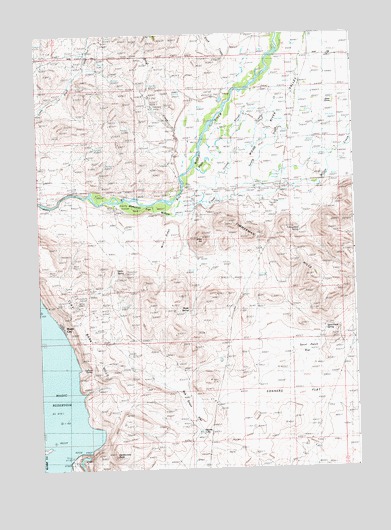
Magic Reservoir East, ID USGS Topographic Map
Click on map above to begin viewing in our Map Viewer.

This topographic map contains these locations and features:
Feature Name Type Latitude Longitude GNIS ID View Map
Black SloughStreamN43.3363°W114.3137°371581View Map
Brock CreekStreamN43.3352°W114.3187°371699View Map
Calhoun SpringSpringN43.2797°W114.3565°371856View Map
Clay Bank HillsSummitN43.2896°W114.3520°396296View Map
Crystal CreekStreamN43.3246°W114.3217°372281View Map
Ditto HillSummitN43.3163°W114.3106°372418View Map
Lava Point Access AreaLocaleN43.2880°W114.2637°401556View Map
Magic CityPopulated PlaceN43.2905°W114.3656°396837View Map
Magic DamDamN43.2508°W114.3641°397887View Map
Mahoney FlatFlatN43.3252°W114.3356°373803View Map
Martin SpringSpringN43.3073°W114.3445°373849View Map
Rattlesnake ButteSummitN43.2541°W114.3459°374582View Map
Reed CreekStreamN43.3652°W114.2995°374631View Map
Rye Grass FlatFlatN43.2649°W114.3103°374820View Map
Sisters GroveAreaN43.3555°W114.2564°375046View Map
Sonners FlatFlatN43.2613°W114.2570°375122View Map
Spring CreekStreamN43.3280°W114.2984°398165View Map
Spud Patch FlatFlatN43.2838°W114.2700°375223View Map
Spud Patch SpringSpringN43.2899°W114.2623°375224View Map
Square LakeLakeN43.2608°W114.3123°375225View Map
Stanton CrossingPopulated PlaceN43.3277°W114.3125°397203View Map
Stanton Crossing Access AreaLocaleN43.3307°W114.3170°401195View Map
Swinging BridgeLocaleN43.3307°W114.3589°375379View Map
Timmerman CemeteryCemeteryN43.3257°W114.2919°375528View Map
Timmerman HillsRangeN43.3046°W114.2664°375529View Map
Timmerman SpringSpringN43.3182°W114.2721°375530View Map
Uhrig MineMineN43.3105°W114.3612°375659View Map
Willow CreekStreamN43.3241°W114.3264°375926View Map
Wind RidgeRidgeN43.3124°W114.3275°375960View Map
Wood River ValleyValleyN43.3335°W114.3153°375988View Map
Wurst SpringSpringN43.2954°W114.3164°376000View Map

Note: Coordinates in the location and feature list above are referenced to NAD83 datum.


Copyright (C) 2008-2025 Ryan Niemi / Sunset Dynamics ... All Rights Reserved