TopoQuest Logo
Do you find TopoQuest useful?
Help keep TopoQuest running and adding new maps/features by donating!
Bitcoin:  19c7KJd3qBynnjoSw5npx9KScwjBe4ifkT
Litecoin:  LXs6TkuXGGXo1vDsWCkWVdjQX94eUKd6ui
Home View Maps Find Maps Find Places Resources & Links


Maize, Kansas Topographic Map

USGS Map Title: Maize, KS
USGS Map MRC: 37097G4
DRG (GeoTIFF) Download: o37097g4.tif


Neighboring USGS Topographic Map Quads:


  Bentley, KS  
37097H5
 

  Sedgwick, KS  
37097H4
 

  Sedgwick NE, KS  
37097H3
 

  Colwich, KS  
37097G5
 

  Maize, KS  
37097G4
 

  Valley Center, KS  
37097G3
 

  Goddard, KS  
37097F5
 

  Wichita West, KS  
37097F4
 

  Wichita East, KS  
37097F3


Map MRC Location:

N38°
W98°
N38°
W97°
H8 H7 H6 H5 H4 H3 H2 H1
G8 G7 G6 G5 G4 G3 G2 G1
F8 F7 F6 F5 F4 F3 F2 F1
E8 E7 E6 E5 E4 E3 E2 E1
D8 D7 D6 D5 D4 D3 D2 D1
C8 C7 C6 C5 C4 C3 C2 C1
B8 B7 B6 B5 B4 B3 B2 B1
A8 A7 A6 A5 A4 A3 A2 A1
N37°
W98°
N37°
W97°

Maize, KS USGS 1:24K Topographic Map Preview:
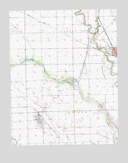
Maize, KS USGS Topographic Map
Click on map above to begin viewing in our Map Viewer.

This topographic map contains these locations and features:
Feature Name Type Latitude Longitude GNIS ID View Map
BerwetPopulated PlaceN37.7856°W97.4837°484655View Map
Brooks Tract ParkParkN37.7631°W97.3934°484089View Map
Childs AcresPopulated PlaceN37.7722°W97.4217°484925View Map
City of MaizeCivilN37.7750°W97.4618°2395820View Map
ColemanPopulated PlaceN37.8642°W97.4639°484656View Map
Complete High School MaizeSchoolN37.7724°W97.4759°2497374View Map
Corn School (historical)SchoolN37.8539°W97.4273°484094View Map
Cuba High SchoolSchoolN37.8058°W97.4537°480210View Map
Edna Buschow Memorial Library Valley CenterBuildingN37.8335°W97.3754°2511084View Map
Ferguson (historical)LocaleN37.8542°W97.3900°484099View Map
Gem School (historical)SchoolN37.7956°W97.3803°484102View Map
Harrison Landing Field (historical)AirportN37.8683°W97.3762°473828View Map
Jester CreekStreamN37.8506°W97.4020°473818View Map
Kansas International DragwayLocaleN37.8014°W97.4387°2692804View Map
Little SloughStreamN37.7567°W97.4342°473823View Map
Luther Airport (historical)AirportN37.8433°W97.3906°481276View Map
MaizePopulated PlaceN37.7792°W97.4673°473821View Map
Maize AirportAirportN37.7656°W97.4359°473827View Map
Maize CemeteryCemeteryN37.7791°W97.4898°473822View Map
Maize Central Elementary SchoolSchoolN37.7738°W97.4714°2497375View Map
Maize City HallBuildingN37.7761°W97.4702°2510295View Map
Maize Elementary SchoolSchoolN37.7715°W97.4715°2497542View Map
Maize High SchoolSchoolN37.7678°W97.4763°480872View Map
Maize Middle SchoolSchoolN37.7670°W97.4620°2497421View Map
Maize Municipal CourtBuildingN37.7761°W97.4702°2510296View Map
Maize Police DepartmentBuildingN37.7561°W97.4599°2503977View Map
Maize Post OfficePost OfficeN37.7774°W97.4676°2510414View Map
Maize Unified School District Number 266 Police DepartmentBuildingN37.7680°W97.4766°2503919View Map
Maize Wastewater PlantLocaleN37.7844°W97.4623°2511241View Map
New Hope Nursing HomeBuildingN37.8360°W97.3820°2510219View Map
Oak Court Mobile Home CourtPopulated PlaceN37.7775°W97.4699°2509908View Map
Prairie Queen School (historical)SchoolN37.8395°W97.4639°484123View Map
Pray - Woodman Elementary SchoolSchoolN37.7722°W97.4745°2497332View Map
Rolling Meadows Mobile Home ParkPopulated PlaceN37.7776°W97.4715°2510920View Map
Sedgwick County Emergency Medical Service Post 14BuildingN37.7560°W97.4607°2696523View Map
Sedgwick County Fire District 1 Station 33BuildingN37.7804°W97.4651°2111851View Map
Township of ParkCivilN37.7883°W97.4304°473831View Map
Township of Valley CenterCivilN37.8686°W97.4271°473830View Map
Valley Center Wastewater Treatment PlantLocaleN37.8262°W97.3802°2510951View Map
Vermillion Elementary SchoolSchoolN37.7718°W97.4700°2497618View Map
Wallace School (historical)SchoolN37.8697°W97.4639°484136View Map
West Elementary SchoolSchoolN37.8376°W97.3817°473825View Map
West Union School (historical)SchoolN37.8245°W97.4267°484137View Map
Wheatland Elementary SchoolSchoolN37.8434°W97.3789°2497543View Map
Wichita Number 3 Wastewater Treatment PlantLocaleN37.7577°W97.4928°2510955View Map
Wilson LakeLakeN37.8081°W97.4298°473824View Map

Note: Coordinates in the location and feature list above are referenced to NAD83 datum.


Copyright (C) 2008-2024 Ryan Niemi / Sunset Dynamics ... All Rights Reserved