TopoQuest Logo
Do you find TopoQuest useful?
Help keep TopoQuest running and adding new maps/features by donating!
Bitcoin:  19c7KJd3qBynnjoSw5npx9KScwjBe4ifkT
Litecoin:  LXs6TkuXGGXo1vDsWCkWVdjQX94eUKd6ui
Home View Maps Find Maps Find Places Resources & Links


Oriental, North Carolina Topographic Map

USGS Map Title: Oriental, NC
USGS Map MRC: 35076A6
DRG (GeoTIFF) Download: o35076a6.tif


Neighboring USGS Topographic Map Quads:


  Bayboro, NC  
35076B7
 

  Vandemere, NC  
35076B6
 

  Jones Bay, NC  
35076B5
 

  Arapahoe, NC  
35076A7
 

  Oriental, NC  
35076A6
 

  Broad Creek, NC  
35076A5
 

  Cherry Point, NC  
34076H7
 

  Merrimon, NC  
34076H6
 

  South River, NC  
34076H5


Map MRC Location:

N36°
W77°
N36°
W76°
H8 H7 H6 H5 H4 H3 H2 H1
G8 G7 G6 G5 G4 G3 G2 G1
F8 F7 F6 F5 F4 F3 F2 F1
E8 E7 E6 E5 E4 E3 E2 E1
D8 D7 D6 D5 D4 D3 D2 D1
C8 C7 C6 C5 C4 C3 C2 C1
B8 B7 B6 B5 B4 B3 B2 B1
A8 A7 A6 A5 A4 A3 A2 A1
N35°
W77°
N35°
W76°

Oriental, NC USGS 1:24K Topographic Map Preview:
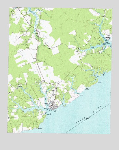
Oriental, NC USGS Topographic Map
Click on map above to begin viewing in our Map Viewer.

This topographic map contains these locations and features:
Feature Name Type Latitude Longitude GNIS ID View Map
AshwoodPopulated PlaceN35.0741°W76.7160°1018869View Map
Benton Farm AirportAirportN35.0989°W76.6289°2679279View Map
Bethel ChurchChurchN35.0991°W76.6266°981119View Map
Blackwell PointCapeN35.0307°W76.6999°981566View Map
Bright CreekStreamN35.0588°W76.6427°981898View Map
Broad Creek ChapelChurchN35.0829°W76.6649°981939View Map
Brown CreekStreamN35.0921°W76.6288°982010View Map
Bulah PointCapeN35.0888°W76.6299°982192View Map
CallisonsPopulated PlaceN35.0843°W76.7252°1019476View Map
Camp CreekStreamN35.0277°W76.7013°982516View Map
Chadwick PointCapeN35.0232°W76.6952°982987View Map
Clancys MarinaHarborN35.0263°W76.7007°2506038View Map
Cockle PointCapeN35.0524°W76.6410°983325View Map
Coffee CreekStreamN35.0932°W76.6288°983338View Map
Cooper PointCapeN35.0154°W76.7035°983508View Map
Dewey PointCapeN35.0254°W76.7033°984160View Map
Fork PointCapeN35.0924°W76.6310°985298View Map
Fork RunStreamN35.0907°W76.7102°985305View Map
GibbtonPopulated PlaceN35.0991°W76.7277°1020424View Map
Gideon CreekStreamN35.0888°W76.6316°985678View Map
Graveyard PointCapeN35.0888°W76.6335°985979View Map
Greens CreekStreamN35.0221°W76.6983°986108View Map
Hamilton PointCapeN35.0904°W76.6377°986336View Map
KershawPopulated PlaceN35.0479°W76.7366°987942View Map
Kershaw CreekStreamN35.0266°W76.7152°987943View Map
MerrittPopulated PlaceN35.0979°W76.7144°1021414View Map
Merritt Post OfficePost OfficeN35.1009°W76.7137°2774315View Map
Moores CornerPopulated PlaceN35.0460°W76.6910°1006301View Map
Morris CreekStreamN35.0396°W76.7035°990264View Map
NelmsPopulated PlaceN35.0516°W76.7049°1021617View Map
Old House CreekStreamN35.0602°W76.6335°991572View Map
Orchard CreekStreamN35.0568°W76.6388°991681View Map
OrientalPopulated PlaceN35.0310°W76.6930°991689View Map
Oriental Harbor MarinaHarborN35.0242°W76.6992°2506055View Map
Oriental Police DepartmentBuildingN35.0288°W76.6950°2131061View Map
Oriental Post OfficePost OfficeN35.0317°W76.6931°2773942View Map
PamlicoPopulated PlaceN35.0849°W76.6349°1021788View Map
Pasture CreekStreamN35.0568°W76.6424°991911View Map
Pierce CreekStreamN35.0399°W76.6624°992171View Map
Pierces ChapelChurchN35.0388°W76.6944°992177View Map
Pilgrim ChapelChurchN35.0416°W76.6938°992195View Map
Piney PointCapeN35.0135°W76.7247°1018694View Map
Raccoon CreekBayN35.0235°W76.6960°992960View Map
Rattlesnake BranchStreamN35.1207°W76.7255°993048View Map
Ship CreekStreamN35.0904°W76.6360°994736View Map
Shop GutBayN35.0207°W76.7030°994765View Map
Smith CreekStreamN35.0252°W76.7010°994962View Map
Southeast Pamlico Volunteer Fire DepartmentBuildingN35.0480°W76.6892°2638267View Map
Southwest Fork Trent CreekStreamN35.1013°W76.7185°995256View Map
Spice CreekStreamN35.1085°W76.6394°995299View Map
Thomas CreekStreamN35.1196°W76.7188°996037View Map
Town of OrientalCivilN35.0353°W76.6818°2407053View Map
Township 2CivilN35.1006°W76.6407°1027019View Map
Trent ChurchChurchN35.1057°W76.7149°996217View Map
Upper McCotter BayBayN35.0441°W76.6547°996555View Map
Whitehurst PointCapeN35.0388°W76.6630°997233View Map
Whittaker CreekStreamN35.0274°W76.6841°997276View Map
Whittaker PointCapeN35.0274°W76.6810°997277View Map
WhortonsvillePopulated PlaceN35.0957°W76.6285°1023234View Map
Wiggins PointCapeN35.0049°W76.7124°997293View Map
Windmill PointCapeN35.0188°W76.7022°997471View Map

Note: Coordinates in the location and feature list above are referenced to NAD83 datum.


Copyright (C) 2008-2025 Ryan Niemi / Sunset Dynamics ... All Rights Reserved