TopoQuest Logo
Do you find TopoQuest useful?
Help keep TopoQuest running and adding new maps/features by donating!
Bitcoin:  19c7KJd3qBynnjoSw5npx9KScwjBe4ifkT
Litecoin:  LXs6TkuXGGXo1vDsWCkWVdjQX94eUKd6ui
Home View Maps Find Maps Find Places Resources & Links


Malakoff, Texas Topographic Map

USGS Map Title: Malakoff, TX
USGS Map MRC: 32096B1
DRG (GeoTIFF) Download: o32096b1.tif


Neighboring USGS Topographic Map Quads:


  Tool, TX  
32096C2
 

  Mabank, TX  
32096C1
 

  Stockard, TX  
32095C8
 

  Kerens, TX  
32096B2
 

  Malakoff, TX  
32096B1
 

  Mallard Hill, TX  
32095B8
 

  Goodlow Park, TX  
32096A2
 

  Creslenn Ranch, TX  
32096A1
 

  Cross Roads, TX  
32095A8


Map MRC Location:

N33°
W97°
N33°
W96°
H8 H7 H6 H5 H4 H3 H2 H1
G8 G7 G6 G5 G4 G3 G2 G1
F8 F7 F6 F5 F4 F3 F2 F1
E8 E7 E6 E5 E4 E3 E2 E1
D8 D7 D6 D5 D4 D3 D2 D1
C8 C7 C6 C5 C4 C3 C2 C1
B8 B7 B6 B5 B4 B3 B2 B1
A8 A7 A6 A5 A4 A3 A2 A1
N32°
W97°
N32°
W96°

Malakoff, TX USGS 1:24K Topographic Map Preview:
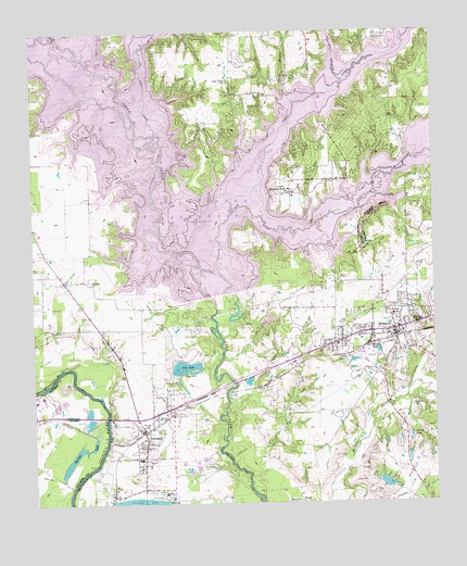
Malakoff, TX USGS Topographic Map
Click on map above to begin viewing in our Map Viewer.

This topographic map contains these locations and features:
Feature Name Type Latitude Longitude GNIS ID View Map
Antioch CemeteryCemeteryN32.1399°W96.0347°1329594View Map
Barnes LakeReservoirN32.1421°W96.0080°1330062View Map
Caney CityPopulated PlaceN32.2254°W96.0330°1378089View Map
Caney City HallBuildingN32.2102°W96.0359°2753820View Map
Caney City Police DepartmentBuildingN32.2102°W96.0359°2751232View Map
Caney City Volunteer Fire DepartmentBuildingN32.2103°W96.0361°2655450View Map
Caney CreekStreamN32.2013°W96.0533°1332085View Map
Cedar Creek Lake DivisionCivilN32.2202°W96.0876°2378355View Map
Church of Christ - MalakoffChurchN32.1721°W96.0116°2021055View Map
City LakeLakeN32.1614°W96.0785°1332862View Map
City of Log CabinCivilN32.2231°W96.0223°2410855View Map
City of MalakoffCivilN32.1727°W96.0162°2410912View Map
City of Malakoff Administrative OfficesBuildingN32.1699°W96.0136°2753216View Map
City of Star HarborCivilN32.1928°W96.0542°2411973View Map
City of TrinidadCivilN32.1562°W96.1054°2412095View Map
Clear CreekStreamN32.2085°W96.0583°1332932View Map
Clear Creek CemeteryCemeteryN32.2376°W96.0414°1332937View Map
Clear Creek ChurchChurchN32.2374°W96.0619°1332939View Map
Daniels LakeLakeN32.1374°W96.1124°1334035View Map
Dry CreekStreamN32.2415°W96.0294°1334679View Map
First Baptist ChurchChurchN32.1702°W96.0236°2021042View Map
Flag LakeLakeN32.1599°W96.0762°1335872View Map
Joe B Hoggsett DamDamN32.1802°W96.0686°1854697View Map
Kilman HospitalHospitalN32.1702°W96.0150°1339111View Map
Log CabinPopulated PlaceN32.2224°W96.0219°1388584View Map
Log Cabin City HallBuildingN32.2259°W96.0209°2753258View Map
Log Cabin Police DepartmentBuildingN32.2262°W96.0223°2751161View Map
Log Cabin Volunteer Fire DepartmentBuildingN32.2244°W96.0132°2655284View Map
Lynn CreekStreamN32.2229°W96.0855°1340760View Map
MalakoffPopulated PlaceN32.1696°W96.0125°1340877View Map
Malakoff Alternative SchoolSchoolN32.1632°W96.0455°2006556View Map
Malakoff Elementary SchoolSchoolN32.1729°W96.0133°2006557View Map
Malakoff High SchoolSchoolN32.1765°W96.0280°2006558View Map
Malakoff Police DepartmentBuildingN32.1699°W96.0136°2751216View Map
Malakoff Post OfficePost OfficeN32.1697°W96.0216°2731222View Map
Malakoff Volunteer Fire DepartmentBuildingN32.1776°W96.0167°2655461View Map
Mankin ChurchChurchN32.1843°W96.1075°1340893View Map
Mary Queen of Heaven Catholic ChurchChurchN32.1849°W96.0308°2021054View Map
Methodist Church of TrinidadChurchN32.1402°W96.0905°2020999View Map
New Hope ChurchChurchN32.1688°W96.0291°2021005View Map
Payne Springs Fire Rescue Station 3BuildingN32.2332°W96.0682°2655453View Map
R H Lee ParkParkN32.1838°W96.0527°2029515View Map
Saint Paul Industrial SchoolSchoolN32.2082°W96.0439°1346083View Map
Spring BranchStreamN32.2335°W96.0441°1347692View Map
Star HarborPopulated PlaceN32.1921°W96.0530°1388585View Map
Star Harbor City OfficesBuildingN32.1951°W96.0563°2753814View Map
Stean CemeteryCemeteryN32.1699°W96.0375°1347844View Map
Texas Power and Light Company LakeReservoirN32.1257°W96.1011°1348418View Map
Town of Caney CityCivilN32.2096°W96.0381°2413158View Map
TrinidadPopulated PlaceN32.1440°W96.0911°1381023View Map
Trinidad City HallBuildingN32.1447°W96.0915°2753970View Map
Trinidad City Lake DamDamN32.1602°W96.0786°1854699View Map
Trinidad Police DepartmentBuildingN32.1447°W96.0915°2751373View Map
Trinidad Post OfficePost OfficeN32.1449°W96.0918°2766540View Map
Trinidad SchoolSchoolN32.1374°W96.0900°2006563View Map
Trinidad Volunteer Fire Department Station 1BuildingN32.1458°W96.0892°2655251View Map
Trinidad Volunteer Fire Department Station 2BuildingN32.1386°W96.0912°2655452View Map
Trinidad Volunteer Fire Department Station 3BuildingN32.2160°W96.1186°2655441View Map
Twin CreekStreamN32.2482°W96.1169°1348942View Map

Note: Coordinates in the location and feature list above are referenced to NAD83 datum.


Copyright (C) 2008-2025 Ryan Niemi / Sunset Dynamics ... All Rights Reserved