TopoQuest Logo
Do you find TopoQuest useful?
Help keep TopoQuest running and adding new maps/features by donating!
Bitcoin:  19c7KJd3qBynnjoSw5npx9KScwjBe4ifkT
Litecoin:  LXs6TkuXGGXo1vDsWCkWVdjQX94eUKd6ui
Home View Maps Find Maps Find Places Resources & Links


Creslenn Ranch, Texas Topographic Map

USGS Map Title: Creslenn Ranch, TX
USGS Map MRC: 32096A1
DRG (GeoTIFF) Download: o32096a1.tif


Neighboring USGS Topographic Map Quads:


  Kerens, TX  
32096B2
 

  Malakoff, TX  
32096B1
 

  Mallard Hill, TX  
32095B8
 

  Goodlow Park, TX  
32096A2
 

  Creslenn Ranch, TX  
32096A1
 

  Cross Roads, TX  
32095A8
 

  Winkler, TX  
31096H2
 

  Roustabout Camp, TX  
31096H1
 

  Cayuga, TX  
31095H8


Map MRC Location:

N33°
W97°
N33°
W96°
H8 H7 H6 H5 H4 H3 H2 H1
G8 G7 G6 G5 G4 G3 G2 G1
F8 F7 F6 F5 F4 F3 F2 F1
E8 E7 E6 E5 E4 E3 E2 E1
D8 D7 D6 D5 D4 D3 D2 D1
C8 C7 C6 C5 C4 C3 C2 C1
B8 B7 B6 B5 B4 B3 B2 B1
A8 A7 A6 A5 A4 A3 A2 A1
N32°
W97°
N32°
W96°

Creslenn Ranch, TX USGS 1:24K Topographic Map Preview:
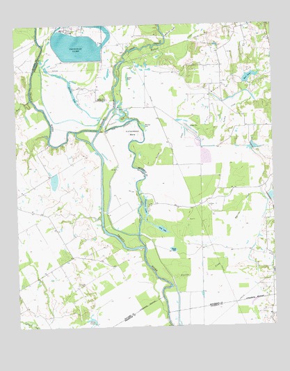
Creslenn Ranch, TX USGS Topographic Map
Click on map above to begin viewing in our Map Viewer.

This topographic map contains these locations and features:
Feature Name Type Latitude Longitude GNIS ID View Map
Cedar CreekStreamN32.0763°W96.0875°1332411View Map
Cottonwood BendBendN32.0821°W96.0669°1333417View Map
Creslenn ParkParkN32.0857°W96.0744°1333660View Map
Creslenn RanchLocaleN32.0943°W96.0850°1333661View Map
Creslenn Ranch DamDamN32.0385°W96.0652°1854693View Map
Creslenn Ranch LakeReservoirN32.0671°W96.0687°1854694View Map
Gallimo LakeLakeN32.0980°W96.0974°1336349View Map
Hall LakeReservoirN32.1031°W96.0110°1337251View Map
Jackson LakeLakeN32.1031°W96.0705°1338596View Map
Long LakeLakeN32.0410°W96.0560°1340493View Map
McAllister SloughStreamN32.1202°W96.0508°1341134View Map
Morrison LakeLakeN32.0831°W96.0629°1341946View Map
Navasota Public LibraryBuildingN32.0099°W96.0772°2014828View Map
Princeton CemeteryCemeteryN32.0174°W96.0958°1344571View Map
Round LakeLakeN32.0322°W96.0499°1345667View Map
Rush CreekStreamN32.0943°W96.1180°1345756View Map
Soil Conservation Service Site 1 DamDamN32.1002°W96.0119°1854691View Map
Soil Conservation Service Site 1 ReservoirReservoirN32.1004°W96.0115°1854692View Map
Soil Conservation Service Site 3 DamDamN32.0752°W96.0102°1854689View Map
Soil Conservation Service Site 3 ReservoirReservoirN32.0744°W96.0093°1854690View Map
Soil Conservation Service Site 4 DamDamN32.0518°W96.0019°1854687View Map
Soil Conservation Service Site 4 ReservoirReservoirN32.0518°W96.0019°1854688View Map
South Malakoff Oil FieldOilfieldN32.1013°W96.0247°1347487View Map
Stephens LakeLakeN32.0503°W96.0626°1347888View Map
Texas Utilities Company Airport (historical)AirportN32.1224°W96.0872°1387653View Map
The CutoffChannelN32.0663°W96.0677°1348439View Map
Trinidad LakeReservoirN32.1173°W96.0939°1348773View Map
Trinidad LeveeDamN32.1118°W96.1036°1854695View Map
Turkey CreekStreamN32.0649°W96.0627°1348871View Map
Walnut CreekStreamN32.1099°W96.0708°1349426View Map

Note: Coordinates in the location and feature list above are referenced to NAD83 datum.


Copyright (C) 2008-2025 Ryan Niemi / Sunset Dynamics ... All Rights Reserved