TopoQuest Logo
Do you find TopoQuest useful?
Help keep TopoQuest running and adding new maps/features by donating!
Bitcoin:  19c7KJd3qBynnjoSw5npx9KScwjBe4ifkT
Litecoin:  LXs6TkuXGGXo1vDsWCkWVdjQX94eUKd6ui
Home View Maps Find Maps Find Places Resources & Links


Park City, Kentucky Topographic Map

USGS Map Title: Park City, KY
USGS Map MRC: 37086A1
DRG (GeoTIFF) Download: o37086a1.tif


Neighboring USGS Topographic Map Quads:


  Rhoda, KY  
37086B2
 

  Mammoth Cave, KY  
37086B1
 

  Horse Cave, KY  
37085B8
 

  Smiths Grove, KY  
37086A2
 

  Park City, KY  
37086A1
 

  Glasgow North, KY  
37085A8
 

  Meador, KY  
36086H2
 

  Lucas, KY  
36086H1
 

  Glasgow South, KY  
36085H8


Map MRC Location:

N38°
W87°
N38°
W86°
H8 H7 H6 H5 H4 H3 H2 H1
G8 G7 G6 G5 G4 G3 G2 G1
F8 F7 F6 F5 F4 F3 F2 F1
E8 E7 E6 E5 E4 E3 E2 E1
D8 D7 D6 D5 D4 D3 D2 D1
C8 C7 C6 C5 C4 C3 C2 C1
B8 B7 B6 B5 B4 B3 B2 B1
A8 A7 A6 A5 A4 A3 A2 A1
N37°
W87°
N37°
W86°

Park City, KY USGS 1:24K Topographic Map Preview:
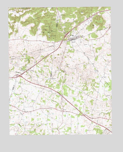
Park City, KY USGS Topographic Map
Click on map above to begin viewing in our Map Viewer.

This topographic map contains these locations and features:
Feature Name Type Latitude Longitude GNIS ID View Map
Apple GrovePopulated PlaceN37.0553°W86.0728°507407View Map
Bald KnobSummitN37.0990°W86.0759°486266View Map
Barrett KnobSummitN37.1185°W86.0338°486440View Map
Bells Tavern Historical MarkerParkN37.0920°W86.0498°2744050View Map
Bon AyrPopulated PlaceN37.0245°W86.0589°507546View Map
Brushy KnobSummitN37.1116°W86.0104°488146View Map
Cedar Hill ChurchChurchN37.1245°W86.0694°489219View Map
City of Park CityCivilN37.0934°W86.0486°2404475View Map
Cox KnobSummitN37.1068°W86.0229°490226View Map
Diamond Caverns Historical MarkerParkN37.1161°W86.0626°2744072View Map
Evergreen CemeteryCemeteryN37.0920°W86.0364°491846View Map
Fairview ChurchChurchN37.0631°W86.0950°491911View Map
Gardner CreekStreamN37.0773°W86.1078°492700View Map
Loving Spring ChurchChurchN37.0378°W86.0064°497227View Map
Merry OaksPopulated PlaceN37.0223°W86.1061°508594View Map
Mount Vernon ChurchChurchN37.0620°W86.0566°498890View Map
Oak Grove ChurchChurchN37.0517°W86.1119°499678View Map
Opossum HollowValleyN37.1084°W86.0732°499962View Map
Park CityPopulated PlaceN37.0939°W86.0464°500179View Map
Park City Fire DeptBuildingN37.0944°W86.0463°2636432View Map
StovallPopulated PlaceN37.0564°W86.0103°509143View Map
The KnobsRidgeN37.1188°W86.0861°505126View Map
Walnut Hill ChurchChurchN37.0678°W86.0530°506184View Map
Woodland ChurchChurchN37.0431°W86.0722°507095View Map
Zion CemeteryCemeteryN37.1006°W86.0541°507275View Map

Note: Coordinates in the location and feature list above are referenced to NAD83 datum.


Copyright (C) 2008-2024 Ryan Niemi / Sunset Dynamics ... All Rights Reserved