TopoQuest Logo
Do you find TopoQuest useful?
Help keep TopoQuest running and adding new maps/features by donating!
Bitcoin:  19c7KJd3qBynnjoSw5npx9KScwjBe4ifkT
Litecoin:  LXs6TkuXGGXo1vDsWCkWVdjQX94eUKd6ui
Home View Maps Find Maps Find Places Resources & Links


Smiths Grove, Kentucky Topographic Map

USGS Map Title: Smiths Grove, KY
USGS Map MRC: 37086A2
DRG (GeoTIFF) Download: o37086a2.tif


Neighboring USGS Topographic Map Quads:


  Brownsville, KY  
37086B3
 

  Rhoda, KY  
37086B2
 

  Mammoth Cave, KY  
37086B1
 

  Bristow, KY  
37086A3
 

  Smiths Grove, KY  
37086A2
 

  Park City, KY  
37086A1
 

  Polkville, KY  
36086H3
 

  Meador, KY  
36086H2
 

  Lucas, KY  
36086H1


Map MRC Location:

N38°
W87°
N38°
W86°
H8 H7 H6 H5 H4 H3 H2 H1
G8 G7 G6 G5 G4 G3 G2 G1
F8 F7 F6 F5 F4 F3 F2 F1
E8 E7 E6 E5 E4 E3 E2 E1
D8 D7 D6 D5 D4 D3 D2 D1
C8 C7 C6 C5 C4 C3 C2 C1
B8 B7 B6 B5 B4 B3 B2 B1
A8 A7 A6 A5 A4 A3 A2 A1
N37°
W87°
N37°
W86°

Smiths Grove, KY USGS 1:24K Topographic Map Preview:
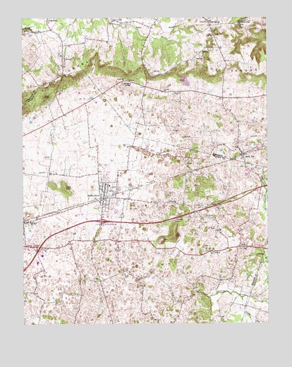
Smiths Grove, KY USGS Topographic Map
Click on map above to begin viewing in our Map Viewer.

This topographic map contains these locations and features:
Feature Name Type Latitude Longitude GNIS ID View Map
Amos Farm (historical)Populated PlaceN37.0617°W86.2345°2742796View Map
Brushy ForkStreamN37.0106°W86.1383°488133View Map
Cedar SpringPopulated PlaceN37.1223°W86.1530°489246View Map
Chicken HollowValleyN37.1010°W86.2140°489469View Map
City of Smiths GroveCivilN37.0503°W86.2083°2405475View Map
Dripping SpringLocaleN37.0987°W86.1928°491117View Map
Green Meadows ChurchChurchN37.0292°W86.1541°493278View Map
HaysPopulated PlaceN37.0314°W86.1389°493927View Map
Hays CemeteryCemeteryN37.0356°W86.1455°493933View Map
High PointSummitN37.0930°W86.2387°494187View Map
Icy Sink ChurchChurchN37.0950°W86.1764°494879View Map
Kinser CemeteryCemeteryN37.1186°W86.2466°495783View Map
Lambert CemeteryCemeteryN37.1195°W86.1528°495938View Map
Liberty ChurchChurchN37.1237°W86.1547°496370View Map
Liberty Hill ChurchChurchN37.0998°W86.1964°496385View Map
Little KnobSummitN37.0559°W86.2281°496779View Map
Little Sinking CreekStreamN37.0631°W86.1291°496861View Map
Little Woodland (historical)Populated PlaceN37.0837°W86.2336°2742800View Map
Moon CemeteryCemeteryN37.0175°W86.2122°498524View Map
Oak Forest ChurchChurchN37.0309°W86.1358°499652View Map
OaklandPopulated PlaceN37.0420°W86.2483°499732View Map
Pilot KnobSummitN37.0360°W86.1722°500641View Map
Rocky HillPopulated PlaceN37.0689°W86.1364°502246View Map
Rocky Hill Fire DepartmentBuildingN37.0700°W86.1379°2636491View Map
Sinking BranchStreamN37.0278°W86.1305°503557View Map
Sinking CreekStreamN37.0134°W86.1614°503561View Map
Smiths GrovePopulated PlaceN37.0525°W86.2078°503812View Map
Smiths Grove DivisionCivilN37.0065°W86.2326°1937262View Map
Smiths Grove KnobSummitN37.0567°W86.2337°2742812View Map
Smiths Grove Police DepartmentBuildingN37.0508°W86.2084°2767793View Map
Smiths Grove Volunteer Fire DepartmentBuildingN37.0515°W86.2081°2636997View Map
Stoney Point (historical)Populated PlaceN37.0493°W86.1729°2742813View Map
Stony Point ChurchChurchN37.0489°W86.1719°504517View Map
WQQB-TV (Bowling Green)TowerN37.0362°W86.1722°518039View Map

Note: Coordinates in the location and feature list above are referenced to NAD83 datum.


Copyright (C) 2008-2024 Ryan Niemi / Sunset Dynamics ... All Rights Reserved