TopoQuest Logo
Do you find TopoQuest useful?
Help keep TopoQuest running and adding new maps/features by donating!
Bitcoin:  19c7KJd3qBynnjoSw5npx9KScwjBe4ifkT
Litecoin:  LXs6TkuXGGXo1vDsWCkWVdjQX94eUKd6ui
Home View Maps Find Maps Find Places Resources & Links


Manchester, Illinois Topographic Map

USGS Map Title: Manchester, IL
USGS Map MRC: 39090E3
DRG (GeoTIFF) Download: o39090e3.tif


Neighboring USGS Topographic Map Quads:


  Winchester, IL  
39090F4
 

  Lynnville, IL  
39090F3
 

  Jacksonville, IL  
39090F2
 

  Alsey, IL  
39090E4
 

  Manchester, IL  
39090E3
 

  Nortonville, IL  
39090E2
 

  Roodhouse West, IL  
39090D4
 

  Roodhouse East, IL  
39090D3
 

  Athensville, IL  
39090D2


Map MRC Location:

N40°
W91°
N40°
W90°
H8 H7 H6 H5 H4 H3 H2 H1
G8 G7 G6 G5 G4 G3 G2 G1
F8 F7 F6 F5 F4 F3 F2 F1
E8 E7 E6 E5 E4 E3 E2 E1
D8 D7 D6 D5 D4 D3 D2 D1
C8 C7 C6 C5 C4 C3 C2 C1
B8 B7 B6 B5 B4 B3 B2 B1
A8 A7 A6 A5 A4 A3 A2 A1
N39°
W91°
N39°
W90°

Manchester, IL USGS 1:24K Topographic Map Preview:
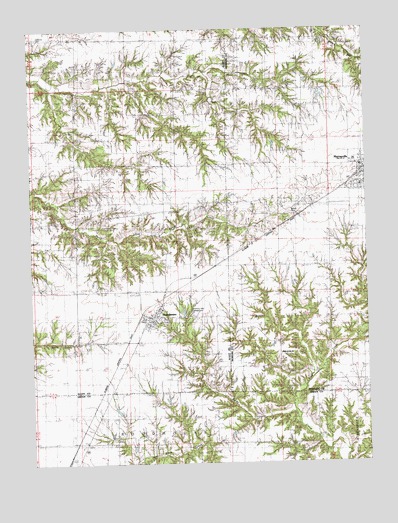
Manchester, IL USGS Topographic Map
Click on map above to begin viewing in our Map Viewer.

This topographic map contains these locations and features:
Feature Name Type Latitude Longitude GNIS ID View Map
Akers School (historical)SchoolN39.5459°W90.3587°403369View Map
Bethel CemeteryCemeteryN39.5714°W90.2782°1748084View Map
Big BranchStreamN39.6078°W90.3668°1821142View Map
Canatsey CemeteryCemeteryN39.6226°W90.3716°1747676View Map
Carnes School (historical)SchoolN39.5567°W90.2829°405616View Map
Coal CreekStreamN39.5156°W90.2790°406287View Map
East Union ChurchChurchN39.5314°W90.2826°1748097View Map
Harmony Hills CampgroundLocaleN39.5442°W90.3173°1747687View Map
Harts School (historical)SchoolN39.6220°W90.3385°409892View Map
Independence School (historical)SchoolN39.5859°W90.3582°410817View Map
ManchesterPopulated PlaceN39.5423°W90.3323°412880View Map
Manchester Baptist ChurchChurchN39.5412°W90.3301°1984643View Map
Manchester CemeteryCemeteryN39.5412°W90.3257°1985763View Map
Manchester Election PrecinctCivilN39.5864°W90.3396°1928561View Map
Manchester Post OfficePost OfficeN39.5411°W90.3316°1984644View Map
Manchester Volunteer Fire DepartmentBuildingN39.5411°W90.3314°2640779View Map
McCracken School (historical)SchoolN39.5817°W90.3248°413236View Map
Mount Olive School (historical)SchoolN39.5067°W90.3482°414026View Map
MurrayvillePopulated PlaceN39.5856°W90.2521°414257View Map
Murrayville Baptist ChurchChurchN39.5795°W90.2518°1984607View Map
Murrayville CemeteryCemeteryN39.5787°W90.2568°1822124View Map
Murrayville Number 2 Election Precinct (historical)CivilN39.5639°W90.2750°1928579View Map
Murrayville Post OfficePost OfficeN39.5861°W90.2511°2788351View Map
Murrayville United Methodist ChurchChurchN39.5800°W90.2518°1984608View Map
Murrayville Volunteer Fire DepartmentBuildingN39.5858°W90.2515°2640796View Map
Oak Hill School (historical)SchoolN39.5964°W90.2779°414830View Map
Old Manchester CemeteryCemeteryN39.5420°W90.3251°1985929View Map
Saint Bartholomew ChurchChurchN39.5859°W90.2535°1984609View Map
Union School (historical)SchoolN39.5348°W90.2835°420105View Map
Village of ManchesterCivilN39.5423°W90.3303°2399238View Map
Village of MurrayvilleCivilN39.5819°W90.2517°2399432View Map
WEAI-FM (Lynnville)TowerN39.6212°W90.2579°428511View Map

Note: Coordinates in the location and feature list above are referenced to NAD83 datum.


Copyright (C) 2008-2025 Ryan Niemi / Sunset Dynamics ... All Rights Reserved