TopoQuest Logo
Do you find TopoQuest useful?
Help keep TopoQuest running and adding new maps/features by donating!
Bitcoin:  19c7KJd3qBynnjoSw5npx9KScwjBe4ifkT
Litecoin:  LXs6TkuXGGXo1vDsWCkWVdjQX94eUKd6ui
Home View Maps Find Maps Find Places Resources & Links


Nortonville, Illinois Topographic Map

USGS Map Title: Nortonville, IL
USGS Map MRC: 39090E2
DRG (GeoTIFF) Download: o39090e2.tif


Neighboring USGS Topographic Map Quads:


  Lynnville, IL  
39090F3
 

  Jacksonville, IL  
39090F2
 

  Alexander, IL  
39090F1
 

  Manchester, IL  
39090E3
 

  Nortonville, IL  
39090E2
 

  Franklin, IL  
39090E1
 

  Roodhouse East, IL  
39090D3
 

  Athensville, IL  
39090D2
 

  Scottville, IL  
39090D1


Map MRC Location:

N40°
W91°
N40°
W90°
H8 H7 H6 H5 H4 H3 H2 H1
G8 G7 G6 G5 G4 G3 G2 G1
F8 F7 F6 F5 F4 F3 F2 F1
E8 E7 E6 E5 E4 E3 E2 E1
D8 D7 D6 D5 D4 D3 D2 D1
C8 C7 C6 C5 C4 C3 C2 C1
B8 B7 B6 B5 B4 B3 B2 B1
A8 A7 A6 A5 A4 A3 A2 A1
N39°
W91°
N39°
W90°

Nortonville, IL USGS 1:24K Topographic Map Preview:
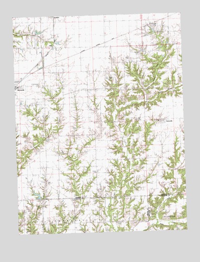
Nortonville, IL USGS Topographic Map
Click on map above to begin viewing in our Map Viewer.

This topographic map contains these locations and features:
Feature Name Type Latitude Longitude GNIS ID View Map
Brush College (historical)SchoolN39.6073°W90.2432°405012View Map
Central Point School (historical)SchoolN39.6212°W90.1818°405872View Map
Ceres CemeteryCemeteryN39.5076°W90.2089°2026101View Map
Ceres School (historical)SchoolN39.5056°W90.2085°405916View Map
ClementsPopulated PlaceN39.6189°W90.1509°406240View Map
Davis CemeteryCemeteryN39.6145°W90.1440°1748091View Map
Durbin School (historical)SchoolN39.6148°W90.1348°407523View Map
East Greasy School (historical)SchoolN39.5378°W90.2185°407653View Map
Henry CemeteryCemeteryN39.6000°W90.1654°1748101View Map
Hill Crest School (historical)SchoolN39.5412°W90.1709°410260View Map
Kennedy School (historical)SchoolN39.5809°W90.2157°411402View Map
Left Fork Apple CreekStreamN39.5037°W90.1471°411922View Map
Little Apple Creek School (historical)SchoolN39.5634°W90.1696°412278View Map
Mooney BranchStreamN39.5742°W90.1532°413768View Map
Murrayville - Woodson Emergency Medical ServicesBuildingN39.5890°W90.2456°2673991View Map
Murrayville Election PrecinctCivilN39.5636°W90.2465°2438415View Map
Murrayville Number 1 Election Precinct (historical)CivilN39.5633°W90.2199°1928578View Map
Murrayville Woodson LakeReservoirN39.6161°W90.2354°1691867View Map
Murrayville Woodson Lake DamDamN39.6150°W90.2368°1691866View Map
Murrayville-Woodson Elementary SchoolSchoolN39.5845°W90.2476°1822125View Map
Nation School (historical)SchoolN39.5200°W90.1276°414297View Map
NortonvillePopulated PlaceN39.5623°W90.1398°414715View Map
Nortonville Election PrecinctCivilN39.5625°W90.1512°1928581View Map
Pleasant Hill School (historical)SchoolN39.5900°W90.1679°415845View Map
Roberts CemeteryCemeteryN39.6074°W90.2201°1748136View Map
Rock BranchStreamN39.5042°W90.1251°416791View Map
Saint Bartholomew CemeteryCemeteryN39.5862°W90.2315°1748140View Map
Sooy CemeteryCemeteryN39.5889°W90.1787°1748147View Map
Spencer School (historical)SchoolN39.5109°W90.2457°418896View Map
Union Grove Church (historical)ChurchN39.5200°W90.1743°420078View Map
Union Grove School (historical)SchoolN39.5062°W90.1682°420081View Map
Ware Brothers PondReservoirN39.5207°W90.2359°1691671View Map
Ware Brothers Pond DamDamN39.5200°W90.2351°1691670View Map
West Greasy School (historical)SchoolN39.5423°W90.2476°420849View Map
Whitlock CemeteryCemeteryN39.5347°W90.1908°421107View Map
Youngblood CemeteryCemeteryN39.5638°W90.1430°1822697View Map
Youngblood ChurchChurchN39.5639°W90.1426°1748157View Map
Zion CemeteryCemeteryN39.5295°W90.2282°418893View Map
Zion Church (historical)ChurchN39.5456°W90.2185°421655View Map
Zion Number One CemeteryCemeteryN39.5464°W90.2168°1748158View Map

Note: Coordinates in the location and feature list above are referenced to NAD83 datum.


Copyright (C) 2008-2025 Ryan Niemi / Sunset Dynamics ... All Rights Reserved