TopoQuest Logo
Do you find TopoQuest useful?
Help keep TopoQuest running and adding new maps/features by donating!
Bitcoin:  19c7KJd3qBynnjoSw5npx9KScwjBe4ifkT
Litecoin:  LXs6TkuXGGXo1vDsWCkWVdjQX94eUKd6ui
Home View Maps Find Maps Find Places Resources & Links


Manning, Texas Topographic Map

USGS Map Title: Manning, TX
USGS Map MRC: 31094B5
DRG (GeoTIFF) Download: o31094b5.tif


Neighboring USGS Topographic Map Quads:


  Lufkin, TX  
31094C6
 

  Huntington, TX  
31094C5
 

  Etoile South, TX  
31094C4
 

  Bald Hill, TX  
31094B6
 

  Manning, TX  
31094B5
 

  Zavalla, TX  
31094B4
 

  Pluck, TX  
31094A6
 

  Wolf Hill, TX  
31094A5
 

  Rockland, TX  
31094A4


Map MRC Location:

N32°
W95°
N32°
W94°
H8 H7 H6 H5 H4 H3 H2 H1
G8 G7 G6 G5 G4 G3 G2 G1
F8 F7 F6 F5 F4 F3 F2 F1
E8 E7 E6 E5 E4 E3 E2 E1
D8 D7 D6 D5 D4 D3 D2 D1
C8 C7 C6 C5 C4 C3 C2 C1
B8 B7 B6 B5 B4 B3 B2 B1
A8 A7 A6 A5 A4 A3 A2 A1
N31°
W95°
N31°
W94°

Manning, TX USGS 1:24K Topographic Map Preview:
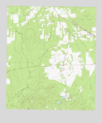
Manning, TX USGS Topographic Map
Click on map above to begin viewing in our Map Viewer.

This topographic map contains these locations and features:
Feature Name Type Latitude Longitude GNIS ID View Map
Bill HillSummitN31.1524°W94.5608°1381440View Map
Brushy CreekStreamN31.1466°W94.5074°1381530View Map
Bufords FieldAirportN31.1727°W94.5325°1386925View Map
Caney CreekStreamN31.1894°W94.5977°1383054View Map
Carrell CemeteryCemeteryN31.2380°W94.5599°1381592View Map
Clayton CreekStreamN31.2263°W94.6146°1383063View Map
Club LakeReservoirN31.1337°W94.5516°1856147View Map
Cowpen BranchStreamN31.1252°W94.5938°1381710View Map
Elm CreekStreamN31.1352°W94.5019°1381842View Map
Gibbs-Flournoy HouseBuildingN31.1419°W94.5408°2031112View Map
Graham CreekStreamN31.2169°W94.6052°1381931View Map
Huntington DivisionCivilN31.2479°W94.5434°1938852View Map
James ChapelChurchN31.2207°W94.5394°1382074View Map
KDFX-AM (Huntington)TowerN31.2291°W94.5699°1385599View Map
Lala Hill ChurchChurchN31.2224°W94.5427°1382118View Map
Little Buck CreekStreamN31.1694°W94.5913°1383126View Map
M M Flournoy DamDamN31.1419°W94.5435°1856144View Map
ManningPopulated PlaceN31.1388°W94.5363°1382227View Map
Manning Club Lake DamDamN31.1352°W94.5502°1856146View Map
Manning Mill PondsReservoirN31.1406°W94.5449°1856145View Map
MillpondReservoirN31.1406°W94.5449°1382308View Map
Possum Trot CreekStreamN31.1452°W94.5044°1383160View Map
Red BranchStreamN31.1571°W94.5033°1366128View Map
Red BranchStreamN31.1580°W94.5038°1383616View Map
Renfro CemeteryCemeteryN31.1646°W94.6196°1382614View Map
Salem ChurchChurchN31.2480°W94.5699°1382684View Map
Shawnee Creek CemeteryCemeteryN31.2116°W94.5296°1382746View Map
Shawnee PrairiePopulated PlaceN31.1796°W94.5438°1382748View Map
Treadwell CemeteryCemeteryN31.2474°W94.5696°1382879View Map

Note: Coordinates in the location and feature list above are referenced to NAD83 datum.


Copyright (C) 2008-2025 Ryan Niemi / Sunset Dynamics ... All Rights Reserved