TopoQuest Logo
Do you find TopoQuest useful?
Help keep TopoQuest running and adding new maps/features by donating!
Bitcoin:  19c7KJd3qBynnjoSw5npx9KScwjBe4ifkT
Litecoin:  LXs6TkuXGGXo1vDsWCkWVdjQX94eUKd6ui
Home View Maps Find Maps Find Places Resources & Links


Zavalla, Texas Topographic Map

USGS Map Title: Zavalla, TX
USGS Map MRC: 31094B4
DRG (GeoTIFF) Download: o31094b4.tif


Neighboring USGS Topographic Map Quads:


  Huntington, TX  
31094C5
 

  Etoile South, TX  
31094C4
 

  Broaddus, TX  
31094C3
 

  Manning, TX  
31094B5
 

  Zavalla, TX  
31094B4
 

  Cassells-Boykin Park, TX  
31094B3
 

  Wolf Hill, TX  
31094A5
 

  Rockland, TX  
31094A4
 

  Boykin Spring, TX  
31094A3


Map MRC Location:

N32°
W95°
N32°
W94°
H8 H7 H6 H5 H4 H3 H2 H1
G8 G7 G6 G5 G4 G3 G2 G1
F8 F7 F6 F5 F4 F3 F2 F1
E8 E7 E6 E5 E4 E3 E2 E1
D8 D7 D6 D5 D4 D3 D2 D1
C8 C7 C6 C5 C4 C3 C2 C1
B8 B7 B6 B5 B4 B3 B2 B1
A8 A7 A6 A5 A4 A3 A2 A1
N31°
W95°
N31°
W94°

Zavalla, TX USGS 1:24K Topographic Map Preview:
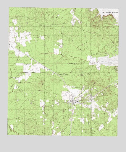
Zavalla, TX USGS Topographic Map
Click on map above to begin viewing in our Map Viewer.

This topographic map contains these locations and features:
Feature Name Type Latitude Longitude GNIS ID View Map
Bald HillSummitN31.1688°W94.4619°1351447View Map
Blue SpringSpringN31.1560°W94.4727°1383700View Map
Blue SpringSpringN31.1564°W94.4725°1352492View Map
BoyntonLocaleN31.2357°W94.4288°1383691View Map
BoyntonPopulated PlaceN31.2357°W94.4296°1379451View Map
City of ZavallaCivilN31.1584°W94.4180°2412330View Map
Dry CreekStreamN31.1899°W94.4983°1383705View Map
Dry CreekStreamN31.1832°W94.4963°1356301View Map
Hawkins CreekStreamN31.1296°W94.4494°1383698View Map
Hawkins CreekStreamN31.1255°W94.4502°1358907View Map
Long Prairie BranchStreamN31.1985°W94.4133°1383693View Map
Long Prairie BranchStreamN31.1991°W94.4130°1361767View Map
McNeil CemeteryCemeteryN31.2266°W94.4430°1383688View Map
McNiel CemeteryCemeteryN31.2269°W94.4416°1362536View Map
MontereyLocaleN31.2305°W94.3938°1383692View Map
MontereyPopulated PlaceN31.2302°W94.3955°1380206View Map
Moss HillSummitN31.1777°W94.4038°1363199View Map
Ozias CemeteryCemeteryN31.2241°W94.4733°1364665View Map
Poland CemeteryCemeteryN31.1382°W94.4602°1383699View Map
Polano CemeteryCemeteryN31.1382°W94.4596°1365512View Map
Ray LakeReservoirN31.1664°W94.3932°1383697View Map
Ray Lake DamDamN31.1652°W94.3919°1862598View Map
Rocky HillSummitN31.1774°W94.4616°1366788View Map
San Augustine Constable's Office Precinct 4BuildingN31.1593°W94.4258°2751205View Map
ShawneeLocaleN31.2130°W94.4996°1383686View Map
ShawneePopulated PlaceN31.2138°W94.4991°1380525View Map
Shoemake BranchStreamN31.1799°W94.4610°1383704View Map
Shoemake BranchStreamN31.1799°W94.4941°1368219View Map
Smith BranchStreamN31.1980°W94.4108°1383694View Map
Smith BranchStreamN31.1994°W94.4108°1368458View Map
Spring BranchStreamN31.1752°W94.4933°1383703View Map
Spring BranchStreamN31.1763°W94.4927°1368932View Map
Townsend CemeteryCemeteryN31.1680°W94.4049°1370058View Map
ZavallaPopulated PlaceN31.1585°W94.4263°1372084View Map
Zavalla Forest Service FacilityLocaleN31.1532°W94.3788°1383574View Map
Zavalla Police DepartmentBuildingN31.1552°W94.4150°2751380View Map
Zavalla Post OfficePost OfficeN31.1589°W94.4241°2732335View Map
Zavalla Volunteer Fire DepartmentBuildingN31.1558°W94.4160°2655242View Map

Note: Coordinates in the location and feature list above are referenced to NAD83 datum.


Copyright (C) 2008-2024 Ryan Niemi / Sunset Dynamics ... All Rights Reserved