TopoQuest Logo
Do you find TopoQuest useful?
Help keep TopoQuest running and adding new maps/features by donating!
Bitcoin:  19c7KJd3qBynnjoSw5npx9KScwjBe4ifkT
Litecoin:  LXs6TkuXGGXo1vDsWCkWVdjQX94eUKd6ui
Home View Maps Find Maps Find Places Resources & Links


Marais Saline, Arkansas Topographic Map

USGS Map Title: Marais Saline, AR
USGS Map MRC: 33092B1
DRG (GeoTIFF) Download: o33092b1.tif


Neighboring USGS Topographic Map Quads:


  Marsden, AR  
33092C2
 

  Vick, AR  
33092C1
 

  Milo, AR  
33091C8
 

  New Union, AR  
33092B2
 

  Marais Saline, AR  
33092B1
 

  Crossett North, AR  
33091B8
 

  Huttig, AR  
33092A2
 

  Felsenthal Dam, AR  
33092A1
 

  Crossett South, AR  
33091A8


Map MRC Location:

N34°
W93°
N34°
W92°
H8 H7 H6 H5 H4 H3 H2 H1
G8 G7 G6 G5 G4 G3 G2 G1
F8 F7 F6 F5 F4 F3 F2 F1
E8 E7 E6 E5 E4 E3 E2 E1
D8 D7 D6 D5 D4 D3 D2 D1
C8 C7 C6 C5 C4 C3 C2 C1
B8 B7 B6 B5 B4 B3 B2 B1
A8 A7 A6 A5 A4 A3 A2 A1
N33°
W93°
N33°
W92°

Marais Saline, AR USGS 1:24K Topographic Map Preview:
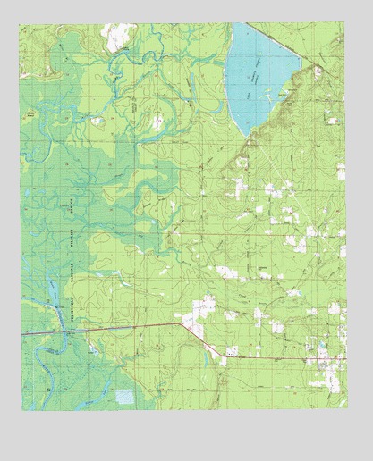
Marais Saline, AR USGS Topographic Map
Click on map above to begin viewing in our Map Viewer.

This topographic map contains these locations and features:
Feature Name Type Latitude Longitude GNIS ID View Map
Arkadelphia CemeteryCemeteryN33.1707°W92.0343°62342View Map
Bell BranchStreamN33.1598°W92.0379°46347View Map
Big Brushy CreekStreamN33.1710°W92.1149°76333View Map
BlanchtonPopulated PlaceN33.2418°W92.0871°75301View Map
Brushy CreekStreamN33.1718°W92.1171°47066View Map
Carroll SloughGutN33.2068°W92.0854°47481View Map
Cooter SchoolSchoolN33.1823°W92.0090°48021View Map
Crossett Harbor Recreation SiteParkN33.1493°W92.1043°75297View Map
Felsenthal National Wildlife RefugeParkN33.1829°W92.1217°75354View Map
Godfrey LandingPopulated PlaceN33.2423°W92.0885°57829View Map
Godfrey Volunteer Fire StationBuildingN33.2473°W92.0897°2116485View Map
Gravel RidgeRidgeN33.1937°W92.0774°49590View Map
Horton IslandIslandN33.2179°W92.1221°77236View Map
Lake Georgia-PacificReservoirN33.2329°W92.0343°80899View Map
Lake Georgia-Pacific DamDamN33.2418°W92.0251°80898View Map
Little Brushy CreekStreamN33.1607°W92.0076°77512View Map
Locke School (historical)SchoolN33.1526°W92.0343°77532View Map
Marais SalineLakeN33.1640°W92.1127°75784View Map
Marie Saline LandingLocaleN33.1487°W92.1076°62352View Map
Maxwell BranchStreamN33.1587°W92.0221°51745View Map
Miller BranchStreamN33.2365°W92.0915°52055View Map
Norwood BranchStreamN33.1704°W92.0582°52850View Map
Round TurnBendN33.2210°W92.1037°60481View Map
United States Fish and Wildlife Felsenthal National Wildlife Refuge Park SecurityBuildingN33.1496°W92.0603°2118694View Map
Wallace SchoolSchoolN33.1923°W92.0007°55984View Map
West Crossett Census Designated PlaceCensusN33.1488°W92.0222°2403000View Map
West Crossett Fire Department Station 91BuildingN33.1410°W92.0164°2117291View Map

Note: Coordinates in the location and feature list above are referenced to NAD83 datum.


Copyright (C) 2008-2025 Ryan Niemi / Sunset Dynamics ... All Rights Reserved