TopoQuest Logo
Do you find TopoQuest useful?
Help keep TopoQuest running and adding new maps/features by donating!
Bitcoin:  19c7KJd3qBynnjoSw5npx9KScwjBe4ifkT
Litecoin:  LXs6TkuXGGXo1vDsWCkWVdjQX94eUKd6ui
Home View Maps Find Maps Find Places Resources & Links


Marsden, Arkansas Topographic Map

USGS Map Title: Marsden, AR
USGS Map MRC: 33092C2
DRG (GeoTIFF) Download: o33092c2.tif


Neighboring USGS Topographic Map Quads:


  Jersey, AR  
33092D3
 

  Hermitage, AR  
33092D2
 

  Sumpter, AR  
33092D1
 

  Moro Bay, AR  
33092C3
 

  Marsden, AR  
33092C2
 

  Vick, AR  
33092C1
 

  New London, AR  
33092B3
 

  New Union, AR  
33092B2
 

  Marais Saline, AR  
33092B1


Map MRC Location:

N34°
W93°
N34°
W92°
H8 H7 H6 H5 H4 H3 H2 H1
G8 G7 G6 G5 G4 G3 G2 G1
F8 F7 F6 F5 F4 F3 F2 F1
E8 E7 E6 E5 E4 E3 E2 E1
D8 D7 D6 D5 D4 D3 D2 D1
C8 C7 C6 C5 C4 C3 C2 C1
B8 B7 B6 B5 B4 B3 B2 B1
A8 A7 A6 A5 A4 A3 A2 A1
N33°
W93°
N33°
W92°

Marsden, AR USGS 1:24K Topographic Map Preview:
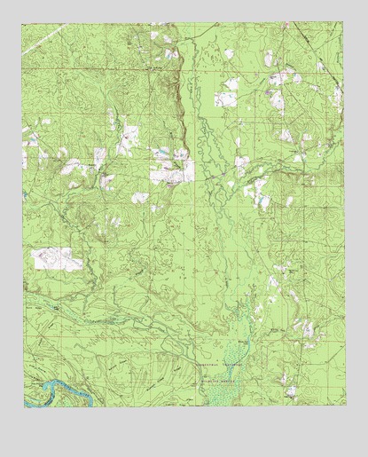
Marsden, AR USGS Topographic Map
Click on map above to begin viewing in our Map Viewer.

This topographic map contains these locations and features:
Feature Name Type Latitude Longitude GNIS ID View Map
Caney BranchStreamN33.3532°W92.1649°47395View Map
Charivari CreekStreamN33.2785°W92.2249°76589View Map
Crossroads Baptist ChurchChurchN33.3326°W92.1432°76718View Map
Eagle Lake ChurchChurchN33.2532°W92.1454°48731View Map
Gar LakeLakeN33.2825°W92.2389°75715View Map
Garrett RidgeRidgeN33.2640°W92.2137°49351View Map
Halfway CreekStreamN33.3132°W92.1735°49775View Map
Hayes RidgeRidgeN33.2743°W92.2424°49960View Map
Lay BranchStreamN33.2787°W92.2110°51013View Map
Lyns CemeteryCemeteryN33.3684°W92.2068°51528View Map
Magnolia Hospital HeliportAirportN33.2746°W92.2390°83761View Map
MarsdenPopulated PlaceN33.3279°W92.2226°58128View Map
Marsden Baptist ChurchChurchN33.3276°W92.2232°60605View Map
Marsden CemeteryCemeteryN33.3262°W92.2232°60607View Map
Marsden Methodist ChurchChurchN33.3279°W92.2238°60606View Map
McKenney CemeteryCemeteryN33.2940°W92.1468°51855View Map
Mill BranchStreamN33.3187°W92.1771°51966View Map
Mill CreekStreamN33.3123°W92.2351°51985View Map
Pine PrairieFlatN33.2626°W92.2454°53464View Map
Pine Prairie BayLakeN33.2571°W92.2418°75823View Map
Russell Camp RidgeRidgeN33.2573°W92.1965°54284View Map
Sand RidgeRidgeN33.2826°W92.2463°54541View Map
Spring SloughStreamN33.2576°W92.2263°78434View Map
Sturgis (historical)Populated PlaceN33.3212°W92.1407°60611View Map
Thomas School (historical)SchoolN33.3596°W92.2001°60608View Map
Township of EagleCivilN33.2765°W92.1434°63688View Map
Tulip Lake (historical)LakeN33.2598°W92.1812°60610View Map
Wearied Rest ChurchChurchN33.3598°W92.1990°56127View Map
Weary Rest CemeteryCemeteryN33.3598°W92.1996°60609View Map
White Oak CreekStreamN33.2696°W92.1624°78754View Map
White Oak LakeLakeN33.2707°W92.1626°78760View Map
York CemeteryCemeteryN33.3351°W92.1312°56605View Map

Note: Coordinates in the location and feature list above are referenced to NAD83 datum.


Copyright (C) 2008-2024 Ryan Niemi / Sunset Dynamics ... All Rights Reserved